Listings (Page 15)
Main & Mersey Dining Room & Coffee Bar
URL: https://novascotia.com/listing/main-and-mersey-dining-room-coffee-bar/
Main Featured Image: https://novascotia.com/wp-content/uploads/2024/09/33082.webp

- Listing_type_tax: 6
- Eat_drink_type:
- Region: South Shore
- Street_address: 267 Main St
- Postal_code: B0T 1K0
- City: 474, Liverpool
- Latitude: 44.03872240421959
- Longitude: -64.71612219606713
- Phone: 902-350-6401
- Email: shani@mainandmerseyhomestore.ca
- Contact_details: Phone, Email
- Description: Discover Main & Mersey Dining Room & Coffee Bar when you visit the town of Liverpool on Nova Scotia’s South Shore. Originally located at 216 Main St with our home store of pottery, fabrics, and decor with the cafe tucked in the back, we have now moved to a new space and welcome you to visit our Coffee Bar and Japanese-fusion restaurant a few steps away at 267 Main St.
Our Coffee Bar offers Dartmouth’s Anchored Coffee for all of our espresso-based coffees which pair beautifully with our fresh French pastries that are baked in-house daily. We also serve tea, juice, kombucha and more.
Our Japanese-fusion restaurant, offering rich Japanese flavours through sauces and spices combined with influences from our European experience, offers a menu that is perfect for sharing with friends and family. From Chicken Karaage to a sushi-inspired Tuna Taco, we encourage our guests to order a few plates to share so everyone can discover the various dishes.
Visit our website to view current hours and to make a dining reservation and be sure to follow us on Facebook to see new menu items and specials.
- Period_of_operation: Open year-round
- Date_details_hours_of_operation: Monday to Friday 8am-4pmSaturday 9am-4pm Sunday 10-3pm in July and August only
- Payment_types:
- Images: https://novascotia.com/wp-content/uploads/2024/09/33082.webp, https://novascotia.com/wp-content/uploads/2024/09/34979.webp
- Restaurant_amenities: 5
- Facebook: https://www.facebook.com/mainandmerseyhomestore/
- Instagram: https://www.instagram.com/mainandmersey/
- Business: Main and Mersey Coffee Bar
- Active_listing: 1
- Website: https://www.mainandmerseyhomestore.ca/pages/coffee-bar-1
- Notes:
- General_area: 46, Liverpool Area
- Google_rating: 4.9
- Primary_contact: 2925
- Restaurant_type: Bakery/Cafe/Coffee House/Tea Room
Main Street Cafe and Lounge
URL: https://novascotia.com/listing/main-street-cafe-and-lounge/
Main Featured Image: https://novascotia.com/wp-content/uploads/2024/09/26606.webp

- Listing_type_tax: 6
- Eat_drink_type:
- Region: Northumberland Shore
- Street_address: 158 Main Street
- City: 14, Antigonish
- Latitude: 45.623628
- Longitude: -61.98733
- Phone: 902-863-4001
- Toll_free: 833-863-4400
- Email: admin@maritimeinnantigonish.ca
- Contact_details: Phone, Toll Free, Email
- Description: Discover one of the best culinary experiences in Antigonish when you dine at the Main Street Cafe and Lounge. Located in the Maritime Inn Antigonish, Main Street Café offers a fantastic menu of Taste of Nova Scotia-inspired dishes at reasonable prices.
Our menu includes unique seasonal recipes featuring our fabulous homemade seafood chowder, loaded with fresh Atlantic seafood including haddock, shrimp, salmon and scallops and another favourite, our panko-crusted haddock, pan-fried to golden brown.
Put the finishing touch on your meal with our decadent house-made desserts, including rich carrot cake, creme brulee and the locals’ favourite, our maple pecan bread pudding.
Our new outdoor patio is the talk of the town, perfect for those warm summer evenings. Find a spot on the patio and be sure to check out our woodfired pizza creations!
- Period_of_operation: Open year-round
- Payment_types:
- Images: https://novascotia.com/wp-content/uploads/2024/09/26606.webp, https://novascotia.com/wp-content/uploads/2024/09/26608.webp, https://novascotia.com/wp-content/uploads/2024/09/26609.webp, https://novascotia.com/wp-content/uploads/2024/09/26610.webp, https://novascotia.com/wp-content/uploads/2024/09/26611.webp, https://novascotia.com/wp-content/uploads/2024/09/26612.webp, https://novascotia.com/wp-content/uploads/2024/09/26613.webp, https://novascotia.com/wp-content/uploads/2024/09/26614.webp, https://novascotia.com/wp-content/uploads/2024/09/26615.webp, https://novascotia.com/wp-content/uploads/2024/09/26616.webp
- Accessibility: Wheelchair accessible
- Onsite_amenities: Parking
- Restaurant_amenities: Children's Menu, 7, 12, Patio, Reservations Recommended
- Facebook: https://www.facebook.com/maritimeinnantigonish/
- Business: Suite Home Hotels Inc. / Maritime Inn Antigonish / Main Street Cafe
- Active_listing: 1
- Website: https://www.maritimeinnantigonish.ca/restaurant
- Notes:
- General_area: 4, Antigonish Area
- Google_rating: 4.3
- Primary_contact: 3109
- Restaurant_type: Breakfast & Brunch, Casual Dining, Family Dining, Pub / Lounge / Bar
- Restaurant_specialties: Canadian / American, East Coast Cuisine, Fish & Chips, Pizza
- Instagram: https://www.instagram.com/maritimeinnantigonish/
Main Street Restaurant
URL: https://novascotia.com/listing/main-street-restaurant/
Main Featured Image: https://novascotia.com/wp-content/uploads/2024/09/26245.webp

- Listing_type_tax: 6
- Eat_drink_type:
- Region: Cape Breton Island
- Street_address: 33776 Cabot Trail
- Postal_code: B0C 1L0
- City: 396, Ingonish Beach
- Latitude: 46.771871
- Longitude: -60.332625
- Phone: 902-285-2225
- Email: mainstreetingonish@gmail.com
- Contact_details: Phone, Email
- Description: Main Street Restaurant and Bakery is situated in the heart of Ingonish on the Cabot Trail.
Our Menu features fresh locally caught Seafood, satisfying Pastas and healthy, delicious meals for all in a casual setting. Vegetarian and Gluten Free options are included. Wine by the Glass or Bottle, Draft Beer, as well as several different Domestic and Imported Beers are available, as well as old fashioned Milk Shakes and Ice Brewed Coffee.
Our in house Bakery serves freshly baked bread, pies, cookies. pastries and bars daily. All of our food is made to order, and even when busy you will be greeted with a smile and friendly service.
- Period_of_operation: Open year-round
- Images: https://novascotia.com/wp-content/uploads/2024/09/26245.webp, https://novascotia.com/wp-content/uploads/2024/09/26246.webp, https://novascotia.com/wp-content/uploads/2024/09/26298.webp
- Facebook: https://www.facebook.com/mainstreetrestaurantingonish/
- Instagram: https://www.instagram.com/mainstreetrestaurant_bakery/?hl=en
- Business: Main Street Restaurant
- Active_listing: 1
- Website: https://www.facebook.com/mainstreetrestaurantingonish/
- Notes:
- General_area: 36, Ingonish Area
- Google_rating: 4.4
- Primary_contact: 2924
Mainland North Trail
URL: https://novascotia.com/listing/mainland-north-trail/
Main Featured Image: https://novascotia.com/wp-content/uploads/2024/09/22166.webp

- Listing_type_tax: 9
- Tours_outdoors:
- Region: Halifax Metro
- Street_address: Parkland Drive
- City: 351, Halifax
- Latitude: 44.680183
- Longitude: -63.678167
- Email: hnwta.communications@gmail.com
- Contact_details: Email
- Description: The Mainland North Trail is a multi-use 4.5-km (9-km return) trail linking from just beyond Washmill Lake Drive to Parkland Drive in Clayton Park, Halifax. The wide pathway has a compacted crusher-dust surface. Jogging is popular along this trail, and the hilly terrain offers a challenge to many! The 1-km wooded loop into the Mainland Common near Westridge Drive adds a quiet walk through natural landscapes, including overlooking a bog. The trail is maintained in the winter, so is no longer suitable for cross-country skiing. Dog walking on leash is permitted.
The trail links several community assets, including schools, the library and the Canada Games Centre, to home and work along the route. Be cautious as the trail crosses several main roads.
- Period_of_operation: Open year-round
- Date_details_hours_of_operation: Plowed in winter.
- Images: https://novascotia.com/wp-content/uploads/2024/09/22166.webp, https://novascotia.com/wp-content/uploads/2024/09/22167.webp, https://novascotia.com/wp-content/uploads/2024/09/22456.webp, https://novascotia.com/wp-content/uploads/2024/09/22457.webp
- Website: https://www.halifaxnorthwesttrails.ca
- Facebook: https://www.facebook.com/HNWTA
- Instagram: https://instagram.com/halifaxnwtrails
- Twitter: https://www.twitter.com/HNWTA_comm
- Business: Halifax North West Trails Association
- Active_listing: 1
- Notes:
- General_area: 35, Halifax/Dartmouth Area
- Google_rating: 4.8
- Primary_contact: 1658
- Trail_distance: 4.5
- Trail_distance_measurement: one way
- Trail_type: Day use
- Trail_surface: Gravel
- Trail_difficulty_level: Easy
- Trail_pet_policy: Leashed
- Trail_uses: Cycling, Hiking, Snowshoeing, Walking
Maison Fiset House
URL: https://novascotia.com/listing/maison-fiset-house/
Main Featured Image: https://novascotia.com/wp-content/uploads/2024/09/28567.webp

- Listing_type_tax: 3
- Accommodation_type:
- Tara_registration_num: STR2526T7327
- Region: Cape Breton Island
- Street_address: 15050 Cabot Trail
- City: 161, Chéticamp
- General_area: 22, Cheticamp Area
- Latitude: 46.622544
- Longitude: -61.018573
- Phone: 902-224-1794
- Toll_free: 855-292-1794
- Email: maisonfisethouse@bellaliant.com
- Contact_details: Phone, Toll Free, Email
- Description: 8 luxurious rooms: 2 king suites, 5 queen rooms, 1 queen barrier free room, ensuite bathrooms (whirlpool in suites) Satellite TV, Wi-Fi, hairdryer, mini fridge, iron and board, private patio. During in season breakfast for inn guests only. 2 fully equipped/furnished housekeeping units. If you have any questions please do not hesitate to contact.
Fresh Breakfast during busy season May 1 -Oct 31
Off-Season Rates available -No breakfast Nov 1 – April 30
$200/daily any available room
- Period_of_operation: Open within a date range
- Open_start_date: May 15, 2025
- Open_end_date: October 16, 2025
- Low_rate: 269
- High_rate: 329
- Rate_period: Per Night
- Rate_details: Weekly rates available upon request
- Payment_types:
- Images: https://novascotia.com/wp-content/uploads/2024/09/28567.webp, https://novascotia.com/wp-content/uploads/2024/09/28568.webp, https://novascotia.com/wp-content/uploads/2024/09/28569.webp, https://novascotia.com/wp-content/uploads/2024/09/28570.webp, https://novascotia.com/wp-content/uploads/2024/09/28571.webp, https://novascotia.com/wp-content/uploads/2024/09/28572.webp, https://novascotia.com/wp-content/uploads/2024/09/28573.webp
- Accommodation_common_amenities: Air Conditioning, Kitchen/Kitchenette, TV (Cable/Sat TV/Smart)
- Onsite_amenities: WiFi
- Pets_policy:
- Number_of_units: 10
- Business: Maison Fiset House
- Active_listing: 1
- Website: https://www.maisonfisethouse.com
- Notes:
- Google_rating: 4.8
- Primary_contact: 1483
Maison St George
URL: https://novascotia.com/listing/maison-st-george/
Main Featured Image: https://novascotia.com/wp-content/uploads/2026/04/MaisonStGeorge-interior.jpg
- Active_listing: 1
- Business: Maison St George
- Primary_contact: 3352
- Listing_type_tax: 6
- Google_rating: 5
- Eat_drink_type:
- Region: Bay of Fundy & Annapolis Valley
- Street_address: 350 St George Street
- City: 13, Annapolis Royal
- General_area: 3, Annapolis Royal Area
- Postal_code: B0S 1A0
- Latitude: 44.7426347
- Longitude: -65.5167979
- Contact_details: Phone, Email
- Phone: 902-995-1854
- Email: info@maisonstgeorge.com
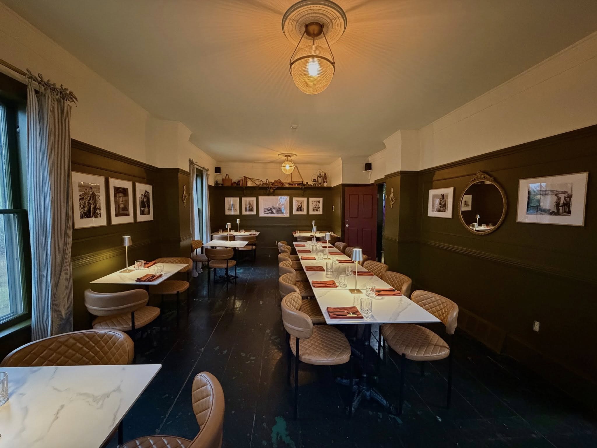
- Description: Maison St George is a European-style bistro, inspired with a touch of Maritime classics, resulting in seasonal menus offering elevated comfort food.
Located within the Garrison House Inn in the historic town of Annapolis Royal, each dish tells a story, one that begins along the windswept coasts of Normandy and finds its way here in Nova Scotia, shaped by the rich maritime spirit we now call home in Annapolis Royal.
Maison, meaning “house,” is a place to create memories, where the salt lingers in the air, the tides set the rhythm, and a well prepared meal is shared among friends and family.
Familiar, yet new. Rooted, yet inspired.
The team has poured their heart and soul into every detail, and look forward to welcoming old friends, new faces, and all those who gather around the table to enjoy a meal at Maison St George.
Hours of Operation
Monday — 11:30am – 8:00pm
Tuesday — Closed
Wednesday — Closed
Thursday — 11:30am – 8:00pm
Friday — 11:30am – 8:00pm
Saturday — 10:00am – 8:00pm
Sunday — 10:00am – 8:00pm
Reservations for parties of six or more can be made by calling 902-995-1854.
- Period_of_operation: Open year-round
- Images: https://novascotia.com/wp-content/uploads/2026/04/MaisonStGeorge-interior.jpg
- Onsite_amenities: Parking
- Restaurant_amenities: Children's Menu, 7, 10, Reservations Recommended, Vegan Options, Vegetarian Options
- Restaurant_type: Bistro, Breakfast & Brunch, Contemporary Casual, Family Dining, Fine Dining / Gourmet
- Restaurant_specialties: Canadian / American, East Coast Cuisine, European, French, 40, 42
- Facebook: https://www.facebook.com/profile.php?id=61583561742358
- Instagram: https://www.instagram.com/maison.stgeorge/
- Notes:
Maison Vacances le Boucanier
URL: https://novascotia.com/listing/maison-vacances-le-boucanier/
Main Featured Image: https://novascotia.com/wp-content/uploads/2024/09/29239.webp

- Listing_type_tax: 3
- Accommodation_type:
- Tara_registration_num: STR2627D2430
- Region: Cape Breton Island
- Street_address: 127 La Pointe du Havre Road
- City: 161, Chéticamp
- Latitude: 46.613842
- Longitude: -61.023809
- Description: This 3 bedroom 100 year old home will charm you. Situated on a quiet street facing the harbour, you will enjoy great sunsets from the deck. Each bedroom has a double bed and the kitchen is fully equipped with everything you will need.
- Period_of_operation: Open within a date range
- Open_start_date: May 1, 2026
- Open_end_date: November 14, 2026
- Low_rate: 249
- High_rate: 299
- Images: https://novascotia.com/wp-content/uploads/2024/09/29239.webp
- Accommodation_common_amenities: Kitchen/Kitchenette, TV (Cable/Sat TV/Smart)
- Onsite_amenities: WiFi
- Pets_policy:
- Number_of_units: 1
- Online_booking:
- Business: Cheticamp Vacation Properties / Les Cabaneaux vacanes JS du Banc / Bénaises Gestion des Propriétés / La Petite Fraise Maison Vacances / Maison Vacances le Boucanier / La Chaloupe Maison Vacances
- Active_listing: 1
- Notes:
- General_area: 22, Cheticamp Area
- Google_rating: 4.1
- Primary_contact: 2486
Major’s Point Historic Site
URL: https://novascotia.com/listing/majors-point-historic-site/
Main Featured Image: https://novascotia.com/wp-content/uploads/2024/09/Majors-Point-new-main-1920x1080-1.jpg

- Listing_type_tax: 4
- Attraction_type:
- Museumhistoric_site_type: Historic Site
- Region: Yarmouth & Acadian Shores
- Street_address: 245 Doucette Point Road
- City: 70, Belliveau Cove
- Latitude: 44.38402
- Longitude: -66.08156
- Phone: 902-769-2345
- Email: tourism@munclare.ca
- Contact_details: Phone, Email
- Description: Major’s Point Historic Site located in Belliveau Cove in the Yarmouth and Acadian Shores region commemorates the arrival of a group of Acadians fleeing the expulsion in 1755.
It is also the site of the first Acadian cemetery on St. Mary’s Bay, which was used as a burial ground until 1786. A replica of The Little Chapel, which dates back to 1892, was built on this site as a reminder of the sacredness of these grounds.
Walking trails connect the site with the nearby Belliveau Cove Municipal Park.
Site improvements were implemented in 2024 including recladding of the chapel, regrading of the cemetery, adding a stone wall and stone crosses. New seasonal restroom onsite.
- Period_of_operation: Open year-round
- Images: https://novascotia.com/wp-content/uploads/2024/09/Majors-Point-new-main-1920x1080-1.jpg, https://novascotia.com/wp-content/uploads/2024/09/Majors-Point-2-1-scaled.jpg, https://novascotia.com/wp-content/uploads/2024/09/Majors-Point-3-scaled.jpg, https://novascotia.com/wp-content/uploads/2024/09/Majors-Point-4.jpg, https://novascotia.com/wp-content/uploads/2024/09/Majors-Point-5-scaled.jpg, https://novascotia.com/wp-content/uploads/2024/09/Majors-Point-6-scaled.jpg, https://novascotia.com/wp-content/uploads/2024/09/Majors-Point-7.jpg, https://novascotia.com/wp-content/uploads/2024/09/Majors-Point-8.jpg
- Onsite_amenities: Parking, Picnic Tables
- Business: Municipality of Clare
- Active_listing: 1
- Website: https://www.baiesaintemarie.com/en/see-and-do/historic-churches/acadian-cemetery-and-chapel
- Notes:
- Google_rating: 4.6
- Primary_contact: 1438
- General_area: 91, Weymouth Area
Malagash Cidery at Vista Bella Farm
URL: https://novascotia.com/listing/malagash-cidery-at-vista-bella-farm/
Main Featured Image: https://novascotia.com/wp-content/uploads/2024/09/19050.webp

- Listing_type_tax: 6
- Eat_drink_type:
- Region: Northumberland Shore
- Street_address: 2859 Malagash Road
- City: 521, Malagash Centre
- Latitude: 45.767041
- Longitude: -63.3367
- Email: vbfarm@gmail.com
- Contact_details: Email
- Description: Vista Bella Farm Orchard, Cidery and Apiary is a first generation farm nestled on the north shore in Malagash Nova Scotia. We started as a small with mixed vegetable farm using a community-supported agriculture model, with members purchasing shares in exchange for fresh produce each week from our farm. We ran this for five years and began to diversify by adding small fruit and larger fruit to our production practices. Eventually, we found that apples, pears and specific vegetable varieties were thriving, so we focused our efforts on growing these crops. Shortly after, we decided to purchase our neighbour’s established orchard as they were retiring.
We continued to experiment with our apples and figured out how to make the most out of what we were growing which included cidery production. We have just planted over 30 new cider varieties as well which brings our total apple variety count to about 110. We also grow dozens of varieties of plums, European pears, Asian pears, and a few cherries. We are committed to continuing to plant funky varieties to both celebrate diversity and to preserve these heirloom varieties for future generations.
Seasonal u-pick opens each September. Please visit our website for more information.
- Period_of_operation: Open seasonally
- Open_start_date: May 20, 2024
- Open_end_date: December 22, 2024
- Date_details_hours_of_operation: weekends only
- Payment_types:
- Images: https://novascotia.com/wp-content/uploads/2024/09/19050.webp, https://novascotia.com/wp-content/uploads/2024/09/10.jpg, https://novascotia.com/wp-content/uploads/2024/09/11.jpg, https://novascotia.com/wp-content/uploads/2024/09/12.jpg, https://novascotia.com/wp-content/uploads/2024/09/14.jpg, https://novascotia.com/wp-content/uploads/2024/09/15.jpg, https://novascotia.com/wp-content/uploads/2024/09/16.jpg, https://novascotia.com/wp-content/uploads/2024/09/17.jpg, https://novascotia.com/wp-content/uploads/2024/09/Vista_Bella_Farm_002_image_credit_Cailin_ONeil_IMG_2998.jpg, https://novascotia.com/wp-content/uploads/2024/09/Vista_Bella_Farm_009_image_credit_Cailin_ONeil_IMG_3022_2.jpg
- Accessibility: Wheelchair accessible
- Facebook: https://www.facebook.com/malagashcidery
- Instagram: https://instagram.com/malagashcidery/?hl=en
- Business: Vista Bella Farm
- Active_listing: 1
- Website: https://www.vistabellafarm.com
- Notes:
- General_area: 87, Tatamagouche Area
- Google_rating: 4.8
- Primary_contact: 2084
- Months_open_seasonally:
Malagash Salt Mine Museum
URL: https://novascotia.com/listing/malagash-salt-mine-museum/
Main Featured Image: https://novascotia.com/wp-content/uploads/2024/09/37.png
- Listing_type_tax: 4
- Attraction_type:
- Museumhistoric_site_type: Museum
- Region: Northumberland Shore
- Street_address: 1926 North Shore Road
- City: 522, Malagash Mine
- General_area: 87, Tatamagouche Area
- Latitude: 45.792381
- Longitude: -63.327222
- Phone: 902-257-2407
- Email: malagash.heritage.association@gmail.com
- Contact_details: Phone, Email
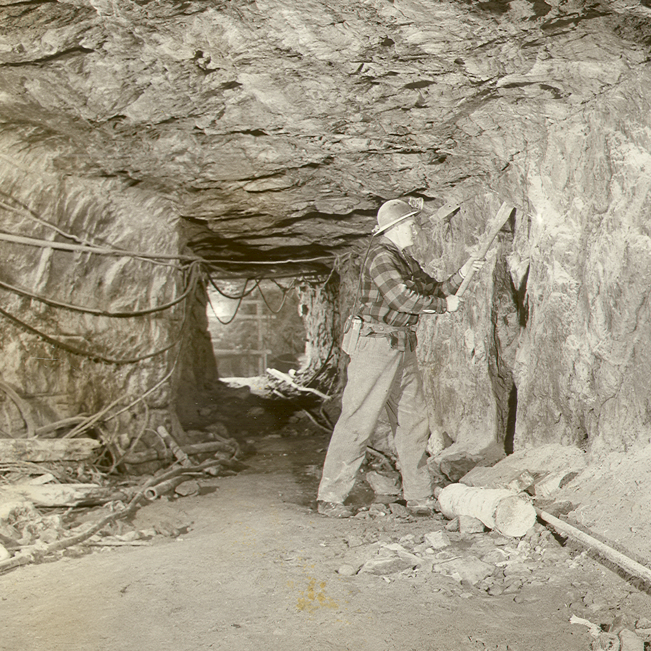
- Description: The Malagash Heritage Museum is a small, local museum devoted to preserving the history and heritage of the Malagash area and the first salt mine in Canada. We have exhibits of various aspects of local history – mining, farming, labour unions, schooling, tools of all kinds of trades applied in Malagash, and daily rural life through the community’s history, which includes oral recordings of long-term residents. We are very proud of Malagash’s claim to fame as being the first rock salt mine in the British Empire. It all began when a farmer desperately needed water, but he only succeeded in getting brine from his well in 1912. On Labour Day, September 2nd, 1918, the first rock salt was mined. After 41 years and a production of approximately 2 million tons of salt, the Malagash Salt mine was closed in March 1959.
Please drop by to review the history of the mine’s operation. The story is told by Malagash residents who remember growing up in the community and working in the salt mine. Their stories of exploring the mine are illustrated by black and white photos, documents, extracts from audio interviews and a unique video clip of mining underground.
- Period_of_operation: Open within a date range
- Open_start_date: June 16, 2026
- Open_end_date: September 12, 2026
- Date_details_hours_of_operation: Tuesday - Saturday 11:00am - 5:00pm
- Rate_details: Admission $2, seniors $1.50, students $1.
- Images: https://novascotia.com/wp-content/uploads/2024/09/37.png, https://novascotia.com/wp-content/uploads/2024/09/Ascending.png, https://novascotia.com/wp-content/uploads/2024/09/Drilling.png, https://novascotia.com/wp-content/uploads/2024/09/Mine8.png, https://novascotia.com/wp-content/uploads/2024/09/Mine10.png, https://novascotia.com/wp-content/uploads/2024/09/11048.webp, https://novascotia.com/wp-content/uploads/2024/09/11049.webp
- Accessibility: Wheelchair accessible
- Onsite_amenities: Gift Shop, Parking, Picnic Tables
- Facebook: https://www.facebook.com/people/Malagash-Heritage-Museum/100076056712651/
- Business: Malagash Area Heritage Association
- Active_listing: 1
- Website: https://www.malagashmuseum.ca/
- Notes:
- Google_rating: 4.2
- Primary_contact: 1084
Mama’s by the Sea B & B
URL: https://novascotia.com/listing/mamas-by-the-sea-bb/
Main Featured Image: https://novascotia.com/wp-content/uploads/2024/09/18925.webp

- Listing_type_tax: 3
- Accommodation_type:
- Tara_registration_num: STR2627B1494
- Region: South Shore
- Street_address: 14 Oscar Street
- City: 171, Clark’s Harbour
- General_area: 8, Barrington Area
- Latitude: 43.44765
- Longitude: -65.63967
- Phone: 902-635-1279
- Email: mamasbythesea@outlook.com
- Contact_details: Phone, Email
- Description: Mama’s is a cozy bed and breakfast accommodation, located in Clark’s Harbour at the most southerly tip of Nova Scotia. Guests can choose between our two guestrooms, each with a comfy queen-size bed. The two rooms share a 4-piece bathroom, making this a wonderful place for families and friends travelling together.
After a great night’s sleep, you’ll wake to the smell of fresh coffee and a full breakfast that is served between 7:00am and 8:30am. Guest amenities also include satellite TV in the common area, Wi-Fi throughout the house, an outdoor fireplace, and the magnificent views overlooking the ocean from the deck and property. Guests can also access the laundry facilities as well as the kitchen
Mama’s by the Sea B & B is located within walking distance to the nearby boardwalk, store, and playground, and is just a short drive from the beautiful The Hawk Beach, home to a “drowned forest” – fossilized tree stumps that are viewable at low tide. You can also swim and beachcomb at the beach as well birdwatch as we are located with an important bird area of Cape Sable Island. Ask us about a boat trip to see rare birds, sand beaches, and “The Cape,” home of the tallest lighthouse in Nova Scotia.
*One small dog lives on premises.
- Period_of_operation: Open year-round
- Low_rate: 159
- High_rate: 159
- Rate_period: Per Night
- Cancellation_policy: 48 hour cancellation policy. Please call to cancel your reservations.
- Payment_types:
- Images: https://novascotia.com/wp-content/uploads/2024/09/18925.webp, https://novascotia.com/wp-content/uploads/2024/09/18926.webp, https://novascotia.com/wp-content/uploads/2024/09/18927.webp, https://novascotia.com/wp-content/uploads/2024/09/18929.webp, https://novascotia.com/wp-content/uploads/2024/09/18930.webp, https://novascotia.com/wp-content/uploads/2024/09/18931.webp, https://novascotia.com/wp-content/uploads/2024/09/18932.webp, https://novascotia.com/wp-content/uploads/2024/09/18933.webp, https://novascotia.com/wp-content/uploads/2024/09/18934.webp
- Accommodation_common_amenities: Breakfast Included, TV (Cable/Sat TV/Smart), Water / Ocean View
- Onsite_amenities: Parking, WiFi
- Membership: Clean It Right
- Pets_policy:
- Number_of_units: 2
- Website: http://www.mamasbythesea.ca/
- Online_booking:
- Facebook: https://www.facebook.com/mamasbythesea
- Business: Mama's by the Sea B & B
- Active_listing: 1
- Notes:
- Primary_contact: 1377
- Google_rating: 5
Manuela’s Cakery
URL: https://novascotia.com/listing/manuelas-cakery/
Main Featured Image: https://novascotia.com/wp-content/uploads/2025/04/ManuelasCakery-1920x1080-1.jpg

- Active_listing: 1
- Business: Manuela's Cakery
- Primary_contact: 3044
- Listing_type_tax: 6
- Google_rating: 4.7
- Eat_drink_type:
- Region: Halifax Metro
- Street_address: 936 Bedford Hwy
- City: 65, Bedford
- General_area: 9, Bedford/Hammonds Plains Area
- Postal_code: B4A 3P1
- Latitude: 44.71500646647826
- Longitude: -63.67942120137584
- Contact_details: Phone, Email
- Phone: 902-407-2002
- Email: info@manuelas.ca
- Description: Manuela’s Cakery is a cozy, European-inspired bakery in Halifax, offering a delightful selection of handcrafted cakes, pastries, and desserts. Established by Manuela, a passionate baker with over 30 years of experience, this charming cakery brings the flavors of Europe to Nova Scotia, using traditional recipes and high-quality ingredients. Whether you’re craving an indulgent slice of cake, a freshly baked pastry, or a custom cake for a special occasion, Manuela’s Cakery has something to satisfy every sweet tooth.
Nestled on Bedford Highway, our café provides a warm and inviting atmosphere—a perfect spot for coffee dates, casual meet-ups, or a quiet moment to enjoy a delicious treat. Known for its Instagram-worthy desserts and elegant European charm, Manuela’s Cakery is a hidden gem for locals and travelers alike.
We take pride in supporting our community, donating to Feed Nova Scotia and other local charities, and ensuring every guest experiences the heartfelt hospitality and homemade goodness that define our bakery.
Whether you’re a Halifax local or just visiting Nova Scotia, stop by Manuela’s Cakery for a taste of Europe with a Nova Scotian touch!
- Period_of_operation: Open year-round
- Payment_types:
- Images: https://novascotia.com/wp-content/uploads/2025/04/ManuelasCakery-1920x1080-1.jpg
- Accessibility: Wheelchair accessible
- Onsite_amenities: WiFi
- Restaurant_amenities: 8, 12
- Restaurant_type: Bakery/Cafe/Coffee House/Tea Room, Pub / Lounge / Bar
- Restaurant_specialties: Acadian, Desserts
- Website: https://manuelascakery.wordpress.com/
- Facebook: https://www.facebook.com/p/Manuelas-Cakery-100034959435138/
- Instagram: https://www.instagram.com/manuelas.cakery/
Maple Inn
URL: https://novascotia.com/listing/maple-inn/
Main Featured Image: https://novascotia.com/wp-content/uploads/2024/09/672ce296819acf0d63caa1963df088f5-1920x1080-1.jpg
- Listing_type_tax: 3
- Accommodation_type:
- Tara_registration_num: STR2627T0606
- Region: Bay of Fundy & Annapolis Valley
- Street_address: 2358 Western Avenue
- Postal_code: B0M 1S0
- City: 660, Parrsboro
- General_area: 65, Parrsboro Area
- Latitude: 45.402582
- Longitude: -64.330777
- Phone: 902-254-3735
- Toll_free: 877-627-5346
- Email: reservations@mapleinn.ca
- Contact_details: Phone, Toll Free, Email
- Description: The Maple Inn is an elegant Victorian mansion (c 1893) situated in the old Town of Parrsboro in the heart of the Cliffs of Fundy Geopark. Our beautifully restored home is two century-old houses joined together furnished with period antiques, offering our guests eight delightful bed and breakfast units and an old-fashioned verandah to relax and enjoy the fresh sea air.
We are just a few steps away from the world’s highest tides and The Ship’s Company Theatre. Enjoy a walk in Parrsboro where you can find unique shops, restaurants and attractions, such as the Fundy Geological Museum and Ottawa House by the Sea Museum. Discover miles of hiking trails, beaches and spectacular scenery along the Fundy Shore. We are also a convenient base for short trips around the Fundy Shore and Annapolis Valley region, such as the Joggins Fossil Cliffs, Anne Murray Centre in Springhill, lighthouse at Cape d’Or and Cape Chignecto Provincial Park.
Our accommodations include 8 guest units (King, Queen, Double, Single): 6 guest rooms with an ensuite 4-piece bath; 2-bedroom guest suite with 2 baths (3-piece with shower and a 4-piece with jacuzzi) and a living room; and a 1-bedroom suite with a 4-piece bath (air-bubble tub). All of our guest units include a flat-screen television, hair dryer and wireless Internet access. A 3-course, chef’s choice, hot breakfast is included with your stay.
Visa, MasterCard and American Express are accepted.
- Period_of_operation: Open within a date range
- Open_start_date: April 1, 2026
- Open_end_date: October 31, 2026
- Low_rate: 135
- High_rate: 325
- Extra_person_rate: 24
- Rate_period: Per Night
- Cancellation_policy: Must cancel 5 days prior to day of arrival to avoid a credit card charge.
- Payment_types:
- Images: https://novascotia.com/wp-content/uploads/2024/09/672ce296819acf0d63caa1963df088f5-1920x1080-1.jpg, https://novascotia.com/wp-content/uploads/2024/09/6fd2f2e027b0da54fce71c9ef376062e-1920x1080-1.jpg, https://novascotia.com/wp-content/uploads/2024/09/29873.webp, https://novascotia.com/wp-content/uploads/2024/09/29874.webp, https://novascotia.com/wp-content/uploads/2024/09/29875.webp, https://novascotia.com/wp-content/uploads/2024/09/29877.webp, https://novascotia.com/wp-content/uploads/2024/09/29900.webp, https://novascotia.com/wp-content/uploads/2024/09/29901.webp, https://novascotia.com/wp-content/uploads/2024/09/IMG_6581-1920x1080-1.jpg, https://novascotia.com/wp-content/uploads/2024/09/IMG_6588-1920x1080-1.jpg
- Accommodation_common_amenities: TV (Cable/Sat TV/Smart), Water / Ocean View
- Onsite_amenities: WiFi
- Pets_policy:
- Number_of_units: 8
- Facebook: https://www.facebook.com/mapleinnparrsboro
- Instagram: https://www.instagram.com/mapleinnparrsboro
- Business: Maple Inn
- Active_listing: 1
- Website: https://www.mapleinn.ca
- Notes:
- Google_rating: 4.9
- Primary_contact: 397
- Ratings_programs: Canada Select
- Cs_rating_bed_breakfast: 4.5
Maple Ridge Cabins
URL: https://novascotia.com/listing/maple-ridge-cabins/
Main Featured Image: https://novascotia.com/wp-content/uploads/2024/09/31248.webp

- Listing_type_tax: 3
- Accommodation_type:
- Tours_outdoors:
- Winter_activity_type: Cross Country Skiing, Snowshoeing
- Tara_registration_num: STR2627T9176
- Region: Cape Breton Island
- Street_address: 27340 Cabot Trail Road
- Postal_code: B0C 1G0
- City: 221, Dingwall
- Latitude: 46.83274
- Longitude: -60.60845
- Phone: 902-285-0483
- Email: capebretoncabins@gmail.com
- Contact_details: Phone, Email
- Description: Nestled in the Cape Breton Highlands mountain range, discover Maple Ridges’ 6 cozy cabins, located next to the Cape Breton Highlands National Park at the halfway point of the scenic Cape Breton Island’s Cabot Trail.
Maple Ridge Cabins is open year-round and is pet friendly accommodation. It’s location offers gorgeous mountain views with opportunities for adventures within minutes of the cabins. The 6 cabins are equipped with everything a visitor would need for a ‘Home Away from Home’ experience. Beautifully decorated cabins with modern décor thoughtfully placed throughout with a full kitchen stocked with all the essentials (pots, pans, cutlery, dishes, etc.), a full bathroom, a comfy queen-sized bed in the bedroom, and a queen-sized sofa bed in the living room for a peaceful night’s sleep.
Whale watching, boat tours, kayaking, fishing, swimming, cross-country skiing, cycling, hiking, snowshoeing, and sledding are some of the many activities that can be enjoyed within minutes of the cabins. Winter, spring, summer and fall – there are opportunities for adventure for everyone!
A crackling fire underneath the starry Cape Breton skies.
Relax in one of our hammocks reading your favorite book with the mountains as your backdrop.
Enjoy your morning coffee out on the deck with the sounds of nature as your morning wake up call.
Hike one of the many scenic trails on a hot summers’ day and return to your air-conditioned cabin to cool down.
These are just a few examples of the experiences to be had and the memories to be made at Maple Ridge Cabins.
We can’t wait to see you!
- Period_of_operation: Open year-round
- Low_rate: 195
- High_rate: 230
- Rate_period: Per Night
- Cancellation_policy: Cancellation Policy: 100% refundable with 2 weeks (14 Days) notice prior to reservation date. 50% refundable with 1 week (7 days) notice prior to reservation date. Non-refundable with 6 days notice prior to reservation date.
- Payment_types:
- Images: https://novascotia.com/wp-content/uploads/2024/09/31248.webp, https://novascotia.com/wp-content/uploads/2024/09/31249.webp, https://novascotia.com/wp-content/uploads/2024/09/31250.webp, https://novascotia.com/wp-content/uploads/2024/09/31251.webp, https://novascotia.com/wp-content/uploads/2024/09/31252.webp, https://novascotia.com/wp-content/uploads/2024/09/31253.webp, https://novascotia.com/wp-content/uploads/2024/09/31254.webp, https://novascotia.com/wp-content/uploads/2024/09/31255.webp, https://novascotia.com/wp-content/uploads/2024/09/31256.webp, https://novascotia.com/wp-content/uploads/2024/09/31257.webp
- Accommodation_common_amenities: Air Conditioning, Kitchen/Kitchenette
- Onsite_amenities: WiFi
- Pets_policy:
- Number_of_units: 6
- Website: https://mapleridgecabins.ca
- Online_booking:
- Facebook: https://www.facebook.com/MapleRidgeCabins
- Instagram: https://www.instagram.com/capebretoncabins/
- Business: Maple Ridge Cabins Inc
- Active_listing: 1
- Notes:
- General_area: 62, North Highlands Area
- Google_rating: 5
- Highlights:
Pet friendly cabins located on the Cabot trail in the Cape Breton Highlands
Close to many activities including whale watching, hiking, kayaking, cross-country skiing, boat tours and more
Open year round
- Primary_contact: 2923
Marble Hill Oasis Vacation Rental
URL: https://novascotia.com/listing/marble-hill-oasis-vacation-rental/
Main Featured Image: https://novascotia.com/wp-content/uploads/2024/09/19983.webp

- Listing_type_tax: 3
- Accommodation_type:
- Tara_registration_num: STR2627A1046
- Region: Cape Breton Island
- Street_address: 739 Marble Hill Road
- City: 694, Port Hood
- Latitude: 46.039176
- Longitude: -61.543096
- Phone: 902-227-5413
- Email: marblehilloasis@bellaliant.net
- Contact_details: Phone, Email
- Description: 2 units: 2-bdrm apt (Q,D), 4-pc bath, SaTV, full kitchen, microwave, dishwasher, laundry, patio set, BBQ; 1 B&B room (Q), pvt 4-pc bath, continental breakfast.
Scenic ocean front view. Common area with SaTV, window seat.
Bank transfers, cheques and cash accepted; no credit cards.
- Period_of_operation: Open within a date range
- Open_start_date: April 1, 2026
- Open_end_date: November 30, 2026
- Low_rate: 950
- High_rate: 950
- Rate_period: Per Week
- Payment_types:
- Images: https://novascotia.com/wp-content/uploads/2024/09/19983.webp
- Accommodation_common_amenities: Kitchen/Kitchenette, TV (Cable/Sat TV/Smart)
- Onsite_amenities: WiFi
- Pets_policy:
- Number_of_units: 2
- Business: Marble Hill Oasis
- Active_listing: 1
- Notes:
- Primary_contact: 1668
- Google_rating: 5
- General_area: 70, Port Hood Area
Marble Mountain Estates
URL: https://novascotia.com/listing/marble-mountain-estates/
Main Featured Image: https://novascotia.com/wp-content/uploads/2024/09/37331.webp

- Listing_type_tax: 6
- Eat_drink_type:
- Region: Cape Breton Island
- Street_address: 5349 Marble Mountain Road
- Postal_code: B0E 3K0
- City: 727, River Denys
- Latitude: 45.810323175124964
- Longitude: -61.05435903191637
- Phone: 902-806-8757
- Email: info@marblewine.ca
- Contact_details: Phone, Email
- Description: Opening in Summer 2026, discover Marble Mountain Estates nestled in the heart of Cape Breton Island, where the rolling slopes of Marble Mountain meet the sparkling shores of the Bras d’Or Lake. Our small vineyard captures the essence of this breathtaking land and each bottle of our wines is a celebration of local grapes infused by Atlantic breezes, of vibrant flavours shaped by the island’s soil and soul, and of the moments that matter most. Raise a glass to Cape Breton’s beauty, culture and the simple joy of sharing something truly special.
Getting here
Marble Mountain Estates is located at 5349 Marble Mountain Road, Cape Breton — just 40 minutes from the Canso Causeway, the gateway to the island. As you cross onto Cape Breton, follow signs toward West Bay and the Bras d’Or Lake. The drive winds through scenic countryside and lakeside views, leading you to our hillside vineyard marked by a welcoming entrance and panoramic vistas.
Membership
Wine Growers of Nova Scotia
Grape Growers of Nova Scotia
- Period_of_operation: Open seasonally
- Open_start_date: July 1, 2025
- Open_end_date: September 2, 2025
- Date_details_hours_of_operation: Tasting room open 11am-4pm daily. Hours of operation change by season.
- Payment_types:
- Images: https://novascotia.com/wp-content/uploads/2024/09/37331.webp, https://novascotia.com/wp-content/uploads/2024/09/37333.webp, https://novascotia.com/wp-content/uploads/2024/09/37334.webp, https://novascotia.com/wp-content/uploads/2024/09/MME-with-view-1920x1080-1.jpg
- Accessibility: Wheelchair accessible
- Onsite_amenities: Parking, Public Washroom, Restaurant/Canteen/Tea Room, WiFi
- Facebook: https://www.facebook.com/marblemountainestates
- Business: Marble Mountain Estates
- Active_listing: 1
- Website: https://www.marblemountainestates.com/
- Notes:
- Google_rating: 5
- Primary_contact: 3085, 3086
- General_area: 92, Whycocomagh Area
- Instagram: https://www.instagram.com/marblemountainestates/
- Youtube: https://www.youtube.com/@MarbleMountainEstates
- Months_open_seasonally:
- Tiktok: https://www.tiktok.com/@marblewine
Marconi National Historic Site
URL: https://novascotia.com/listing/marconi-national-historic-site/
Main Featured Image: https://novascotia.com/wp-content/uploads/2024/09/23109.webp

- Listing_type_tax: 4
- Attraction_type:
- Museumhistoric_site_type: Historic Site
- Tours_outdoors:
- Tara_registration_num: n/a
- Region: Cape Breton Island
- Street_address: 15 Timmerman Street, Table Head
- City: 301, Glace Bay
- General_area: 30, Glace Bay Area
- Latitude: 46.211061
- Longitude: -59.952512
- Phone: 902-842-2530
- Email: lnh-agb-nhs@pc.gc.ca
- Contact_details: Phone, Email
- Description: Celebrate technology and innovation at Table Head, Glace Bay – the site of Guglielmo Marconi’s first permanent transatlantic wireless station. This historic event kicked off the age of global wireless communications, and changed the world forever.
Visit the exhibit and chat with expert guides to learn about this fascinating history and how it connects to technology today. Tap out a Morse code message, explore the foundations of the original aerial towers, and see where a vision of being always connected first began.
In December 1902, a wire antenna suspended from four giant wooden towers beamed an official wireless message across the Atlantic. The awe-inspiring view of the Atlantic Ocean adds to the experience, providing a picturesque backdrop that compliments the historical significance of Marconi’s wireless station location. Walk along the coastal trail to see what remains of the Table Head Station and marvel at the breathtaking view of the ocean. Stay awhile and enjoy the green space surrounding the museum with a family picnic.
Marconi National Historic Site is located within the traditional and unceded territory of the Mi’kmaq.
- Period_of_operation: Open within a date range
- Open_start_date: July 1, 2026
- Open_end_date: September 7, 2026
- Date_details_hours_of_operation: 9am–5pm Daily
- Rate_details: Admission free; donations accepted.
- Images: https://novascotia.com/wp-content/uploads/2024/09/23109.webp, https://novascotia.com/wp-content/uploads/2024/09/23110.webp, https://novascotia.com/wp-content/uploads/2024/09/23114.webp, https://novascotia.com/wp-content/uploads/2024/09/23115.webp, https://novascotia.com/wp-content/uploads/2024/09/23118.webp, https://novascotia.com/wp-content/uploads/2024/09/28029.webp, https://novascotia.com/wp-content/uploads/2024/09/28030.webp, https://novascotia.com/wp-content/uploads/2024/09/28031.webp, https://novascotia.com/wp-content/uploads/2024/09/28032.webp, https://novascotia.com/wp-content/uploads/2024/09/30611.webp
- Accessibility: Wheelchair accessible
- Onsite_amenities: Parking, Picnic Tables
- Government_level:
- Facebook: https://www.facebook.com/MarconiNHS
- Instagram: https://www.instagram.com/parks.canada
- Twitter: https://twitter.com/ParksCanada_NS
- Youtube: https://youtube.com/user/ParksCanadaAgency
- Business: Parks Canada - Cape Breton
- Active_listing: 1
- Website: https://parks.canada.ca/lhn-nhs/ns/marconi
- Notes:
- Google_rating: 3.8
- Primary_contact: 2073
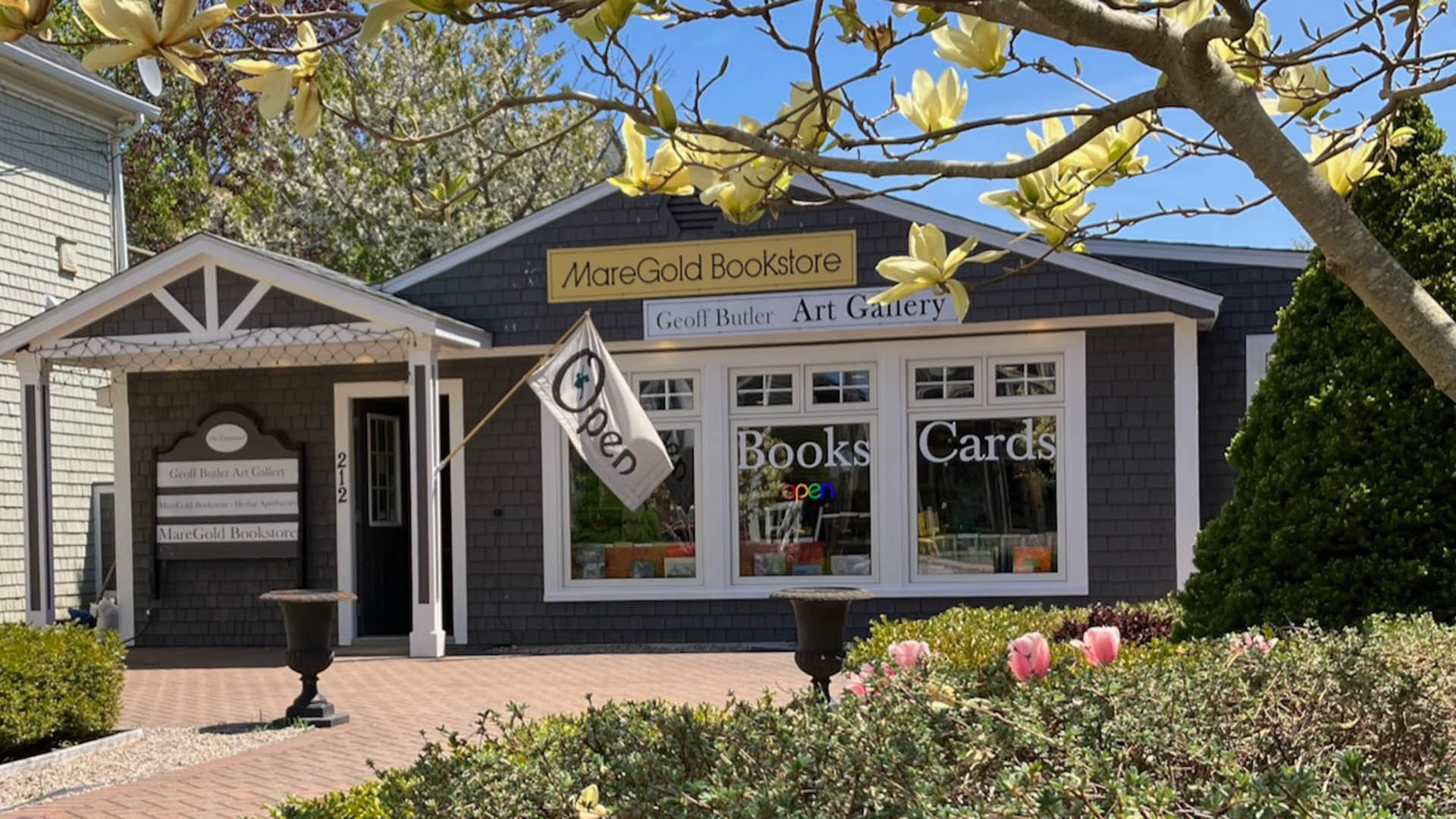
MareGold Bookstore and Gallery
URL: https://novascotia.com/listing/maregold-bookstore-gallery/
Main Featured Image: https://novascotia.com/wp-content/uploads/2024/09/image0-1920x1080-1.jpg
- Listing_type_tax: 4
- Attraction_type:
- Artisan_gallery_type: Unique Shop
- Region: Bay of Fundy & Annapolis Valley
- Street_address: 212 St George Street
- Postal_code: B0S 1A0
- City: 13, Annapolis Royal
- Latitude: 44.74522
- Longitude: -65.51891
- Phone: 709-689-2794
- Email: russellnf@gmail.com
- Contact_details: Phone, Email
- Description:
A specially curated collection of over 10,000 new non-fiction books. We also have an art gallery with historical and contemporary original art. If you love books, come explore MareGold Bookstore — a favourite stop for visitors and locals alike.
Art & design books, History, nature, and maritime subjects, Herbalism, wellness, and sustainability, Unique and hard-to-find non-fiction
Customers comment about the shop being beautiful, welcoming, and thoughtfully curated, with a peaceful place to browse and helpful recommendations.
- Period_of_operation: Open year-round
- Date_details_hours_of_operation: May through December - seven days a week.January through April: Wednesday - Saturday, 10am-4pm
- Images: https://novascotia.com/wp-content/uploads/2024/09/image0-1920x1080-1.jpg, https://novascotia.com/wp-content/uploads/2024/09/32431.webp, https://novascotia.com/wp-content/uploads/2024/09/32432.webp
- Facebook: https://www.facebook.com/TheCourtyardARTBOOKSFOOD
- Business: MareGold Centre
- Active_listing: 1
- Website: https://maregoldbookstore.com
- General_area: 3, Annapolis Royal Area
- Primary_contact: 2922
- Google_rating: 4.5
- Notes:
MareGold Centre
URL: https://novascotia.com/listing/maregold-centre/
Main Featured Image: https://novascotia.com/wp-content/uploads/2024/09/32415.webp

- Listing_type_tax: 3
- Accommodation_type:
- Tours_outdoors:
- Tara_registration_num: STR2627B2668
- Region: Bay of Fundy & Annapolis Valley
- Street_address: 514 Granville Road
- Postal_code: B0S 1A0
- City: 899, Victoria Beach
- Latitude: 44.68938
- Longitude: -65.75593
- Email: info@maregold.com
- Contact_details: Email
- Description: The MareGold Retreat Centre is located on 32 acres of stunning oceanfront property in the village of Victoria Beach, 30 kilometres from the town of Annapolis Royal, in the southern Annapolis Valley, Nova Scotia.
The MareGold Centre is a seasonal, off-grid retreat and creative hub on the Bay of Fundy coast, dedicated to sustainable living, natural building, and hands-on learning. Nestled between ocean views and spruce forest, MareGold offers a peaceful, private setting for rest, reflection, and reconnection with the land.
We are home to a growing collection of handcrafted demonstration cabins, each designed with reclaimed materials and a strong sense of place. These cabins are not only places to stay—they’re part of a larger conversation about how we live, build, and create with care and intention.
Throughout the season, MareGold hosts small workshops in cabin-building, natural design, off-grid living, and herbalism. These immersive, creative gatherings are led by skilled makers, herbalists, and builders who share their craft and stories in a practical, supportive environment.
The MareGold Centre is a completely non-smoking property, including all cabins, trails, gardens, and both interior and exterior spaces.
This is a place for sunsets and stillness. Our guests come to unplug, reconnect with nature, and slow down. There are no TVs, and only one cabin has internet. It’s a rare chance to enjoy quiet, creativity, and deep rest—off the beaten path.
The MareGold Centre is not open to the public year-round. We welcome visitors only at special times—during workshops, events, and select retreat stays. This keeps the space intentional, grounded, and in tune with the natural world.
Classes/groups come together in the rustic meeting buildings, outdoor meeting spaces overlooking the Bay of Fundy and in other woodland natural settings.
Accommodations
Guests can choose from a variety of cabins built in private settings around the property. Each cabin is individually designed to align with the natural environment, whether situated on a cliff to take advantage of the ocean view or nestled in a wilderness sanctuary. Each cabin is individually designed and built using locally milled lumber and as many reclaimed materials as possible.
When not in use by retreat/program participants the cabins are offered for rent as weekend getaways or for a longer term lease.
- Period_of_operation: Open within a date range
- Open_start_date: May 1, 2026
- Open_end_date: December 31, 2026
- Rate_period: Per Night
- Payment_types:
- Images: https://novascotia.com/wp-content/uploads/2024/09/32415.webp, https://novascotia.com/wp-content/uploads/2024/09/32416.webp, https://novascotia.com/wp-content/uploads/2024/09/32417.webp
- Accommodation_common_amenities: Kitchen/Kitchenette
- Onsite_amenities: WiFi
- Pets_policy:
- Number_of_units: 8
- Online_booking:
- Facebook: https://www.facebook.com/MareGoldRetreat/
- Business: MareGold Centre
- Active_listing: 1
- Website: https://www.maregold.com/
- Notes:
- General_area: 3, Annapolis Royal Area
- Google_rating: 5
- Primary_contact: 2922
Margaree Fish Hatchery
URL: https://novascotia.com/listing/margaree-fish-hatchery/
Main Featured Image: https://novascotia.com/wp-content/uploads/2024/09/32037.webp

- Listing_type_tax: 4
- Attraction_type:
- Museumhistoric_site_type: Interpretive Centre
- Campground_type:
- Region: Cape Breton Island
- Street_address: 115 Hatchery Road
- City: 532, Margaree Valley
- General_area: 53, Margaree Area
- Latitude: 46.37235
- Longitude: -60.96822
- Phone: 902-248-2845
- Email: jamie.vallis@novascotia.ca
- Contact_details: Phone, Email
- Description: The oldest fish hatchery in Nova Scotia; produces over 250,000 Atlantic salmon and brook trout to support recreational fishing. Interpretive centre; outdoor ponds.
- Period_of_operation: Open year-round
- Date_details_hours_of_operation: 9am–4pm daily.
- Images: https://novascotia.com/wp-content/uploads/2024/09/32037.webp
- Accessibility: Wheelchair accessible
- Onsite_amenities: Parking, Picnic Tables
- Government_level:
- Business: Margaree Fish Hatchery
- Active_listing: 1
- Website: https://novascotia.ca/fish/documents/MHbrochure.pdf
- Notes:
- Google_rating: 4.4
- Primary_contact: 3208
- Gardens_parks_&_farms_types: Agri-tourism / Farm / U-pick
Margaree Harbour View Inn B&B
URL: https://novascotia.com/listing/margaree-harbour-view-inn-bb/
Main Featured Image: https://novascotia.com/wp-content/uploads/2024/09/19221.webp

- Listing_type_tax: 3
- Accommodation_type:
- Tara_registration_num: STR2627B9770
- Region: Cape Breton Island
- Street_address: 4018 Shore Road
- Postal_code: B0E 2B0
- City: 531, Margaree Harbour
- General_area: 53, Margaree Area
- Latitude: 46.433389
- Longitude: -61.107353
- Phone: 902-235-2314
- Email: harbourviewinn@msn.com
- Contact_details: Phone, Email
- Description: 3 rooms (Q,D,T), shared 4-pc bath. SaTV in lounge, reading room; full breakfast. An inn since the early 1920s; furnished with antiques. Fantastic view from veranda of Margaree Highland Mountains at mouth of salmon-fishing Margaree River. Ocean swimming.
- Period_of_operation: Open year-round
- Low_rate: 150
- High_rate: 250
- Extra_person_rate: 20
- Rate_period: Per Night
- Payment_types:
- Images: https://novascotia.com/wp-content/uploads/2024/09/19221.webp
- Onsite_amenities: WiFi
- Number_of_units: 3
- Business: Margaree Harbour View Inn B&B
- Active_listing: 1
- Notes:
- Primary_contact: 434
- Google_rating: 4.3
Margaree Salmon Museum
URL: https://novascotia.com/listing/margaree-salmon-museum/
Main Featured Image: https://novascotia.com/wp-content/uploads/2024/09/5500.webp

- Listing_type_tax: 4
- Attraction_type:
- Museumhistoric_site_type: Historic Site, Museum
- Region: Cape Breton Island
- Street_address: 60 East Big Intervale Road
- City: 629, North East Margaree
- General_area: 53, Margaree Area
- Latitude: 46.327566
- Longitude: -61.005482
- Phone: 902-248-2848
- Toll_free: 902 248 2180
- Email: margareesalmonmuseum@gmail.com
- Contact_details: Phone, Toll Free, Email
- Description: “Cape Breton offers a surprisingly large number of wonderful quirky museums. My favourite, by far, was the Margaree Salmon Museum.” Alan Burdick, The New York Times.
Established in 1965, The Margaree Salmon Museum is located beside the Cabot Trail in Northeast Margaree, Cape Breton.
This historical gem connects the people of the area to its natural resources and highlights their contribution to the history of the famed Atlantic Salmon. Local guides made early angling icons famous through their river knowledge, often shared in innkeeper’s kitchens over home cooked meals. Or, even a wee dram. Salmon angling Icons like John Cosseboom regularly camped on the river’s banks, Lee Wulff caught his first Atlantic Salmon here and the angling gear of a 1930’s British spy hangs here. Their stories, and many others, plus numerous angling and non-angling artifacts from by-gone-years are housed here. Come visit and listen to our curators talk about them. You’ll come back.
- Period_of_operation: Open seasonally
- Open_start_date: June 21, 2025
- Open_end_date: October 15, 2025
- Date_details_hours_of_operation: Open 9 am to 4 pm Wednesday through Sunday ( Closed Monday and Tuesday )
mid-June to mid-October
- Rate_details: Admission: adult $5, child $2.
- Payment_types:
- Images: https://novascotia.com/wp-content/uploads/2024/09/5500.webp
- Accessibility: Wheelchair accessible
- Onsite_amenities: Parking, Picnic Tables, Public Washroom
- Website: https://www.margareesalmonmuseum.ca
- Facebook: https://www.facebook.com/Margaree-salmon-museum
- Instagram: https://www.instagram.com/margaree_salmon_museum
- Business: Margaree Salmon Museum
- Active_listing: 1
- Notes:
- Google_rating: 4.8
- Primary_contact: 576
- Months_open_seasonally:
Margaree Valley Maple
URL: https://novascotia.com/listing/margaree-valley-maple/
Main Featured Image: https://novascotia.com/wp-content/uploads/2026/01/MargareeValleyMaple.jpg

- Active_listing: 1
- Business: Margaree Valley Maple
- Primary_contact: 3234
- Listing_type_tax: 6
- Eat_drink_type:
- Region: Cape Breton Island
- Street_address: 119 Timmons Road
- City: 532, Margaree Valley
- General_area: 53, Margaree Area
- Postal_code: B0E 2C0
- Latitude: 46.3822634711073
- Longitude: -61.00288903125753
- Contact_details: Phone, Email
- Description: A mountain of maple trees where we tap for maple syrup – with a walking trail.
Margaree Valley Maple is a family-run maple producer in Cape Breton, Nova Scotia. Visitors can tour the property, sample maple syrup (including classic taffy on snow), and try maple products like maple butter.
The experience highlights both traditional and modern syrup-making techniques in a beautiful valley setting and can be paired with a Jeep tour from Cape Breton Backcountry Adventures, for a full outing. Guests learn about the process from tapping the trees to boiling in the sugar shack, celebrating spring and the rich local bounty of the Margaree Valley.
- Period_of_operation: Open seasonally
- Months_open_seasonally:
- Date_details_hours_of_operation: depending on the season
- Images: https://novascotia.com/wp-content/uploads/2026/01/MargareeValleyMaple.jpg
- Accessibility: Partially accessible
- Facebook: https://www.facebook.com/margareevalleymaple/
- Instagram: https://www.instagram.com/margareevalleymaple/#
- Notes:
- Phone: 902-248-2631
- Email: elmermarthahart@gmail.com
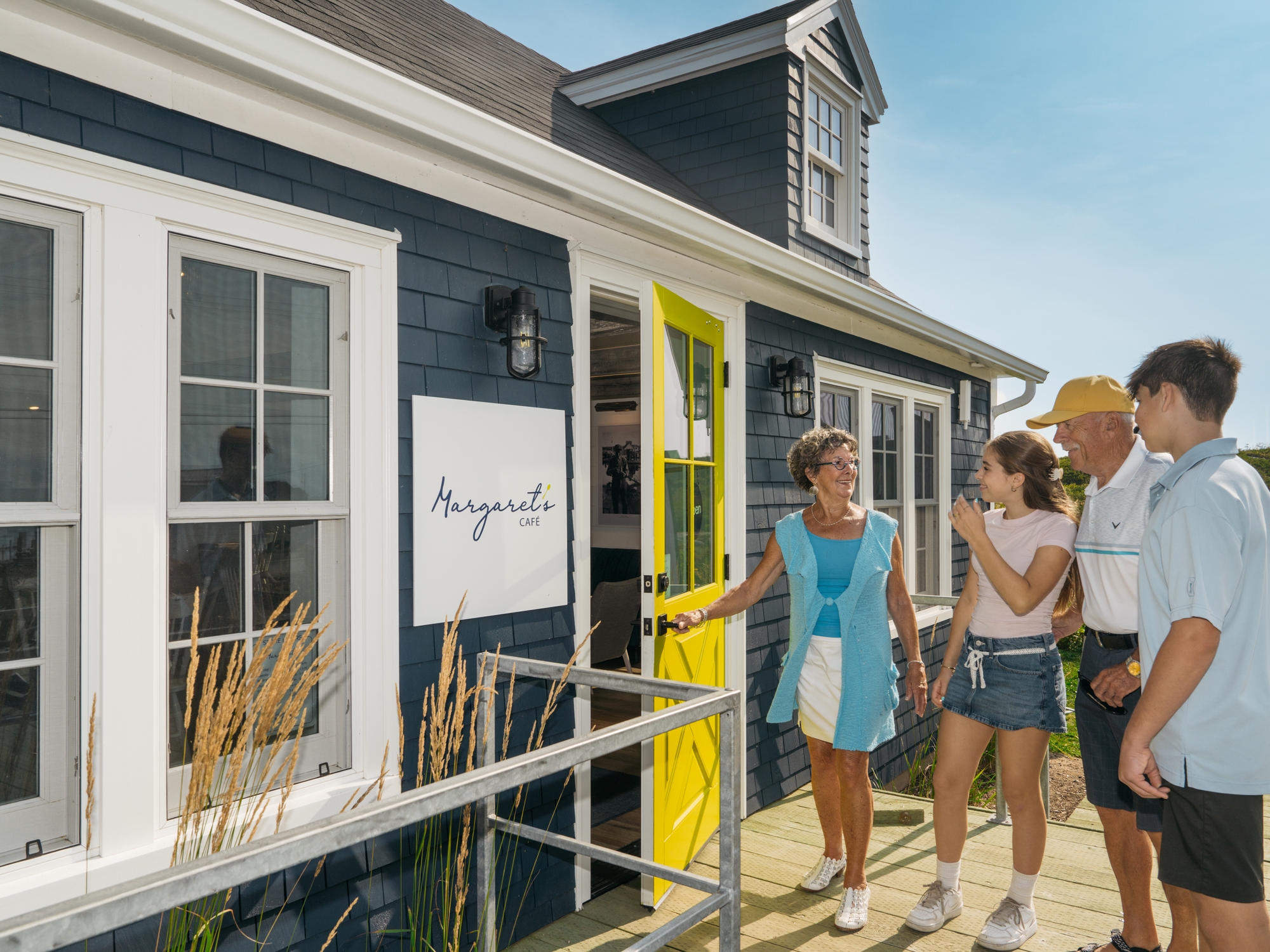
Margaret’s Café
URL: https://novascotia.com/listing/margarets-cafe/
Main Featured Image: https://novascotia.com/wp-content/uploads/2025/04/DCMP-2025_Peggy_s-Cove-3_NovaScotia.com_2000x1500.jpg
- Active_listing: 1
- Business: Six by the Sea, Inc. / Hunky Dory / Margaret's Café / Spindrift Gallery
- Primary_contact: 3010
- Listing_type_tax: 6
- Google_rating: 4.8
- Eat_drink_type:
- Region: South Shore
- Street_address: 126 Peggy’s Point Road
- City: 661, Peggy’s Cove
- General_area: 66, Peggy's Cove Area
- Postal_code: B3Z 3S2
- Latitude: 44.492964337901974
- Longitude: -63.91475990335493
- Contact_details: Email
- Description: Overlooking iconic fishing boats in picturesque Peggy’s Cove, Nova Scotia, Margaret’s is a cozy East Coast café serving freshly brewed coffee and tea, seafood chowder, delicious gourmet grab-and-go freshly pressed paninis, and Maritime-inspired baked goods.
- Period_of_operation: Open within a date range
- Date_details_hours_of_operation: Monday – Wednesday: 9 a.m. – 5 p.m.
Thursday – Sunday: 9 a.m. – 6 p.m.
- Images: https://novascotia.com/wp-content/uploads/2025/04/DCMP-2025_Peggy_s-Cove-3_NovaScotia.com_2000x1500.jpg, https://novascotia.com/wp-content/uploads/2025/04/MargaretsCafé-1920x1080-1.jpg
- Accessibility: Wheelchair accessible
- Onsite_amenities: WiFi
- Restaurant_amenities: 5, 11, Patio
- Restaurant_type: Bakery/Cafe/Coffee House/Tea Room, Casual Dining
- Website: https://margaretsns.ca/
- Facebook: https://www.facebook.com/margaretsns
- Instagram: https://www.instagram.com/margaretsns
- Notes:
- Email: info@margaretsns.ca
- Open_start_date: May 7, 2026
- Open_end_date: October 25, 2026
Margaretsville Art Shack Gallery
URL: https://novascotia.com/listing/margaretsville-art-shack/
Main Featured Image: https://novascotia.com/wp-content/uploads/2024/09/8066.webp

- Listing_type_tax: 4
- Attraction_type:
- Artisan_gallery_type: Unique Shop
- Tara_registration_num: n/a
- Region: Bay of Fundy & Annapolis Valley
- Street_address: 37 Haddock Alley
- City: 533, Margaretsville
- Latitude: 45.0487
- Longitude: -65.063299
- Phone: 902-824-5084
- Email: artistscirclens@gmail.com
- Contact_details: Email
- Description: Art in many mediums and styles showcasing up to 15 local Annapolis Valley artists. You will be greeted by one of our co-operative gallery artists and, you may even catch them painting and creating their magic on site. Come down to the Margaretsville Wharf and enjoy art with a view of the awe-inspiring Fundy Shore noted by the highest tides in the world.
Cash, debit and credit cards accepted.
- Period_of_operation: Open within a date range
- Open_start_date: June 13, 2026
- Open_end_date: September 20, 2026
- Date_details_hours_of_operation: Open mid-June to mid-September. Please visit our website for up-to-date information on dates and hours.
- Payment_types:
- Images: https://novascotia.com/wp-content/uploads/2024/09/8066.webp, https://novascotia.com/wp-content/uploads/2024/09/8067.webp, https://novascotia.com/wp-content/uploads/2024/09/8068.webp, https://novascotia.com/wp-content/uploads/2024/09/8069.webp
- Facebook: https://www.facebook.com/ArtistsCircle.NS
- Business: The Artists' Circle of Annapolis Valley Co-Operative Ltd / Margaretsville Art Shack Gallery
- Active_listing: 1
- Notes:
- General_area: 44, Kingston/Greenwood Area
- Google_rating: 4.9
- Website: https://theartistscircle.ca/
- Primary_contact: 1537
- Instagram: https://www.instagram.com/theartshackgallery?igsh=MW5tdXM5c3IsYWlidA==
- Months_open_seasonally:
Margaretsville Boathouse Heritage Centre and Boardwalk
URL: https://novascotia.com/listing/margaretsville-boathouse-heritage-centre-and-boardwalk/
Main Featured Image: https://novascotia.com/wp-content/uploads/2024/09/25534.webp

- Listing_type_tax: 4
- Attraction_type:
- Tara_registration_num: n/a
- Region: Bay of Fundy & Annapolis Valley
- Street_address: Haddock Alley
- Postal_code: B0S 1N0
- City: 533, Margaretsville
- Latitude: 45.048546
- Longitude: -65.063038
- Description: As part of the community shoreline park, the Boathouse Heritage Centre and Boardwalk allow visitors the opportunity to explore Margaretsville’s shipbuilding and fishing legacy through artifacts and displays at the historic boathouse, stroll the wheelchair accessible boardwalk or walk the scenic pebbled beach to a nearby waterfall.
Picnic tables and firepits are also available.
The adjacent wharf and Art Shack gallery together with the community’s distinctive black and white striped lighthouse add much to the community’s charm.
Community hall ice cream parlor every Sunday afternoon in the summer.
- Period_of_operation: Open seasonally
- Open_start_date: January 3, 1970
- Open_end_date: January 3, 1970
- Date_details_hours_of_operation: Open late June to early September
- Rate_details: Free
- Images: https://novascotia.com/wp-content/uploads/2024/09/25534.webp, https://novascotia.com/wp-content/uploads/2024/09/25535.webp, https://novascotia.com/wp-content/uploads/2024/09/25536.webp, https://novascotia.com/wp-content/uploads/2024/09/25537.webp, https://novascotia.com/wp-content/uploads/2024/09/25538.webp
- Accessibility: Wheelchair accessible
- Accommodation_common_amenities: 34, 36
- Onsite_amenities: Public Washroom
- Business: Margaretsville Shore Society
- Active_listing: 1
- Notes:
- General_area: 44, Kingston/Greenwood Area
- Google_rating: 5
- Website: https://www.facebook.com/margaretsvilleshoresociety/
- Primary_contact: 2492
- Months_open_seasonally:
Marguerite boutique et provisions
URL: https://novascotia.com/listing/marguerite-boutique-et-provisions/
Main Featured Image: https://novascotia.com/wp-content/uploads/2025/10/art_2_round_3-1920x1080-1.jpg

- Active_listing: 1
- Business: Groupe Bridou Hospitality / L’abri Restaurant & Bar / Marguerite boutique et provisions / The Archie & Isidore Hotel / Cheticamp Outback Inn / Auberge Doucet
- Primary_contact: 3184
- Listing_type_tax: 4, 6
- Google_rating: 4.8
- Eat_drink_type:
- Region: Cape Breton Island
- Street_address: 15347 Cabot Trail
- City: 161, Chéticamp
- General_area: 22, Cheticamp Area
- Postal_code: B0E 1H0
- Latitude: 46.63345735596219
- Longitude: -61.00995921775601
- Contact_details: Phone, Email
- Phone: 902-224-2145
- Email: manager@boutiquemarguerite.ca
- Description: Marguerite boutique et provisions is an ode to Chéticamp general stores of old, while also looking distinctly to the future of the village. The building itself has held different iterations of stores for over 100 years: among them Tucker’s, The Lucky Dollar, Chez Luce, Le P’tit Chady and now, Marguerite boutique et provisions.
Here we showcase the talent of local artisans and artists as well as home goods, fine foods, and environmentally sustainable products in our gift shop while serving up baked goods, pastries, espresso and coffee in our on-site cafe.
- Period_of_operation: Open year-round
- Images: https://novascotia.com/wp-content/uploads/2025/10/art_2_round_3-1920x1080-1.jpg, https://novascotia.com/wp-content/uploads/2025/10/CKP_8067_CDENE-1920x1080-1.jpg, https://novascotia.com/wp-content/uploads/2025/10/iced_coffee-1920x1080-1.jpg, https://novascotia.com/wp-content/uploads/2025/10/BAKED_GOODS-1920x1080-1.jpg, https://novascotia.com/wp-content/uploads/2025/10/CKP_7992_CDENE-1920x1080-1.jpg, https://novascotia.com/wp-content/uploads/2025/10/marguerite_sitting-1920x1080-1.jpg, https://novascotia.com/wp-content/uploads/2025/10/ART_1-1920x1080-1.jpg
- Restaurant_amenities: 5
- Restaurant_type: Bakery/Cafe/Coffee House/Tea Room
- Restaurant_specialties: Baked goods
- Website: https://www.boutiquemarguerite.ca/
- Facebook: https://www.facebook.com/margueriteboutiqueprovisions
- Instagram: https://www.instagram.com/boutiquemarguerite
- Notes:
- Attraction_type:
- Artisan_gallery_type: Unique Shop
- Art_product_type:
Marie à Padée Maison Vacance
URL: https://novascotia.com/listing/marie-a-padee-maison-vacance/
Main Featured Image: https://novascotia.com/wp-content/uploads/2024/09/20960.webp

- Listing_type_tax: 3
- Accommodation_type:
- Tara_registration_num: STR2526A4954
- Region: Cape Breton Island
- Street_address: 58 Old Cabot Trail Road
- City: 320, Grand Etang
- Latitude: 46.549031
- Longitude: -61.042785
- Phone: 902-224-2569
- Email: marieapade@gmail.com
- Contact_details: Phone, Email
- Description: 3-bdrm house (Q), 2 baths (3-pc (S) & 4-pc), SaTV, Wi-Fi, sofa-bed in one bedroom, full kitchen, dishwasher, washer, dryer, BBQ. 10-acre property on the Old Cabot Trail, overlooking picturesque fishing harbour; beautiful view of the highlands. Walking distance to Mi-Carême Centre, walking trail.
- Period_of_operation: Open within a date range
- Open_start_date: April 1, 2026
- Open_end_date: October 31, 2026
- Low_rate: 521
- Rate_period: Per Night
- Rate_details: Three night minimum.
- Payment_types:
- Images: https://novascotia.com/wp-content/uploads/2024/09/20960.webp
- Accommodation_common_amenities: Kitchen/Kitchenette, TV (Cable/Sat TV/Smart)
- Onsite_amenities: WiFi
- Pets_policy:
- Number_of_units: 1
- Online_booking:
- Business: Marie à Padée Maison Vacance
- Active_listing: 1
- Notes:
- General_area: 22, Cheticamp Area
- Google_rating: 5
- Primary_contact: 1608
- Highlights: Minimum stay 3 nights
Marie Joseph Provincial Park
URL: https://novascotia.com/listing/marie-joseph-provincial-park/
Main Featured Image: https://novascotia.com/wp-content/uploads/2024/09/8659.webp

- Listing_type_tax: 9
- Campground_type:
- Tours_outdoors:
- Region: Eastern Shore
- Street_address: 1420 Highway 7
- City: 534, Marie Joseph
- General_area: 81, Sherbrooke Area
- Latitude: 44.967767
- Longitude: -62.086583
- Email: parkinfo@novascotia.ca
- Contact_details: Email
- Description: Marie Joseph Provincial Park in Marie Joseph (1420 Highway 7) on the Eastern Shore is a picturesque roadside picnic park on the ocean with a view of offshore islands. Picnic tables are scattered under softwoods overlooking the rocky shoreline.
- Period_of_operation: Open within a date range
- Open_start_date: May 17, 2025
- Open_end_date: October 14, 2025
- Date_details_hours_of_operation: (dates subject to change)
- Payment_types:
- Images: https://novascotia.com/wp-content/uploads/2024/09/8659.webp
- Government_level:
- Facebook: https://www.facebook.com/NSProvincialParks
- Business: Department of Natural Resources and Renewables / Provincial Park
- Active_listing: 1
- Website: https://parks.novascotia.ca/content/marie-joseph
- Notes:
- Google_rating: 4.6
- Primary_contact: 1662
Marina Bar & Grill
URL: https://novascotia.com/listing/marina-bar-grill/
Main Featured Image: https://novascotia.com/wp-content/uploads/2025/10/DSC7601_NovaScotia.com_2000x1500.jpg
- Active_listing: 1
- Business: Marina Bar & Grill
- Primary_contact: 1074
- Listing_type_tax: 6
- Google_rating: 4.2
- Eat_drink_type:
- Region: Northumberland Shore
- Street_address: 67 Caladh Ave
- City: 667, Pictou
- General_area: 67, Pictou/Caribou Area
- Latitude: 45.67523429087558
- Longitude: -62.71082632351573
- Contact_details: Phone, Email
- Phone: 902-485-5000
- Email: marinabargrillcanva@gmail.com
- Description: Located right on the Pictou waterfront, visit Marina Bar & Grill for stunning harbour views and friendly, warm Nova Scotia hospitality. This popular year-round restaurant features classic pub fare alongside Nova Scotia favourites like donair poutine, fish cakes, fish and chips, and the local favourite, pan fried haddock. A staple on the waterfront, Marina Bar & Grill invites locals and visitors alike to relax, enjoy hearty comfort food, and soak in the scenic atmosphere, with one of the best waterfront views in the province.
- Highlights:
Located on the Pictou waterfront
Menu featuring classic pub fare and Nova Scotia favourites
Visit for live music, local seafood, or if lucky, a view of the Ship Hector
- Period_of_operation: Open year-round
- Date_details_hours_of_operation: Sunday 7:00 a.m. – 8:00 p.m., Monday 11:00 a.m. -9:00 p.m., Tuesday – Thursday 7:00 a.m. – 8:00 p.m., Friday & Saturday, 7:00 a.m. – 10:00 p.m.
- Images: https://novascotia.com/wp-content/uploads/2025/10/DSC7601_NovaScotia.com_2000x1500.jpg, https://novascotia.com/wp-content/uploads/2025/10/DSC7533_NovaScotia.com_2000x1500.jpg, https://novascotia.com/wp-content/uploads/2025/10/marina-bar-and-grill-1-1920x1080-1.jpg, https://novascotia.com/wp-content/uploads/2025/10/marina-bar-and-grill-2-1920x1080-1.jpg
- Restaurant_amenities: Live Entertainment, Patio
- Restaurant_type: Family Dining
- Restaurant_specialties: Seafood
- Facebook: https://www.facebook.com/p/Marina-Bar-Grill-61575822073085/
Mariner Cruises Whale & Seabird Tours off Brier Island
URL: https://novascotia.com/listing/mariner-cruises-whale-seabird-tours/
Main Featured Image: https://novascotia.com/wp-content/uploads/2024/09/MarinerCruises-whaletail-1920x1080-1.jpg

- Listing_type_tax: 9
- Attraction_type:
- Museumhistoric_site_type: Historic Site
- Tours_outdoors:
- Boating_sailing_type: Boat Tour
- Region: Bay of Fundy & Annapolis Valley
- Street_address: 325 Water Street
- Postal_code: B0V 1H0
- City: 951, Westport
- General_area: 16, Brier Island/Long Island Area
- Latitude: 44.261437
- Longitude: -66.354205
- Phone: 902-839-2346
- Toll_free: 800-239-2189
- Email: whales@novascotiawhalewatching.ca
- Contact_details: Phone, Toll Free, Email
- Description: Mariner Cruises has been offering Nova Scotia whale watching and birding tours off Brier Island, in the Bay of Fundy since 1994. We invite you to join us for an exciting sea adventure from the Whale Watching Capital of Nova Scotia!
Come explore Brier Island and the magnificent Bay of Fundy, home to inspiring marine life, rare bird species and the friendliest people you can meet. Finback whales, minke whales and harbour porpoises are the first to arrive in the spring. In June, the humpbacks begin to return; by late June they are abundant, and Atlantic white-sided dolphins are often seen. All tours are narrated by local naturalists, who are well-versed in the dozens of marine mammals and bird species that visit this important ecological region.
Mariner Cruises is owned and operated by Penny Graham, lifelong resident of Westport, Brier Island. The company has been offering unique whale watching and seabird adventures since 1994. Tours run from late June to early October. Tours are approximately 3 hours in length and sail at 8:30 am 12:30 pm and 4:30 pm daily, weather and passenger count permitting. Accommodation/whale watching packages are available.
Please note : Travel to Brier Island requires two separate ferry trips. Please check schedules and plan accordingly.
- Period_of_operation: Open within a date range
- Open_start_date: June 15, 2025
- Open_end_date: October 15, 2025
- Date_details_hours_of_operation: 8:30am, 12:30pm & 4:30pm daily weather and passenger count permitting. Tours are approx. 3 hours in length.
- Payment_types:
- Images: https://novascotia.com/wp-content/uploads/2024/09/MarinerCruises-whaletail-1920x1080-1.jpg, https://novascotia.com/wp-content/uploads/2024/09/15181.webp, https://novascotia.com/wp-content/uploads/2024/09/15182.webp, https://novascotia.com/wp-content/uploads/2024/09/15184.webp, https://novascotia.com/wp-content/uploads/2024/09/15185.webp, https://novascotia.com/wp-content/uploads/2024/09/15186.webp
- Website: https://www.novascotiawhalewatching.ca
- Facebook: http://www.facebook.com/Mariner.Cruises
- Instagram: http://instagram.com/mariner_cruises/
- Twitter: http://twitter.com/MarinerCruises
- Youtube: http://www.youtube.com/user/marinercruises
- Business: Mariner Cruises Whale & Seabird Tours and The Bay of Fundy Inn
- Active_listing: 1
- Guided_tour: 1
- Notes:
- Google_rating: 4.9
- Primary_contact: 634
Maritime Express Cider Company
URL: https://novascotia.com/listing/maritime-express-cider-company/
Main Featured Image: https://novascotia.com/wp-content/uploads/2024/10/21603.webp

- Listing_type_tax: 6
- Eat_drink_type:
- Tara_registration_num: n/a
- Region: Bay of Fundy & Annapolis Valley
- Street_address: 325 Main Street
- City: 426, Kentville
- Latitude: 45.07726
- Longitude: -64.49365
- Phone: 902-681-5105
- Email: info@maritimeexpress.ca
- Contact_details: Phone, Email
- Description: The Maritime Express Cider Co. is a cidery and taproom located in what was once the stone patio of an iconic railway hotel located in Kentville, Nova Scotia.
The taproom offers a place to purchase a large selection of our growlers and bottles, while also providing a place to sit down and grab a pint. Take time to appreciate that the building was once known as one of Canada’s most architecturally beautiful hotels. In a rush? Grab a bottle or growler of our cider to go. For the craft beer lovers, we also have a rotating selection of our favorite craft beer from around the province and beyond.
Small batch premium ciders
Keeping it small means that our cider maker can ensure that every drop reaches its full potential. Our small batch ciders are crafted from a custom blend of 100% Annapolis Valley apples. First, we hand select the perfect mix of apples ensuring that each batch is created with the highest quality fusion of sweet, sharp and bitter. Our selection is then locally pressed, cold fermented underneath the taproom’s stone floors, and brought directly to our taps for your enjoyment.
From 1930 to 1973, the Cornwallis Inn was a mecca for social events in Nova Scotia. As a Dominion Atlantic Railroad hotel, it represented the glory days of railway travel in Canada.
A formidable Tudoresque building of concrete and masonry construction, it was considered one of the most architecturally beautiful hotels in Canada. It contained ninety guest rooms, including four luxury suites, and ten sample rooms for commercial travellers.
This iconic building now known as the Main Street Station, is home to the Maritime Express Cider Co.’s retail and tasting room with a full gastropub kitchen.
- Period_of_operation: Open year-round
- Images: https://novascotia.com/wp-content/uploads/2024/10/21603.webp, https://novascotia.com/wp-content/uploads/2024/10/21604.webp, https://novascotia.com/wp-content/uploads/2024/10/21605.webp, https://novascotia.com/wp-content/uploads/2024/10/21606.webp, https://novascotia.com/wp-content/uploads/2024/10/37944.webp, https://novascotia.com/wp-content/uploads/2024/10/37945.webp, https://novascotia.com/wp-content/uploads/2024/10/37946.webp, https://novascotia.com/wp-content/uploads/2024/10/37947.webp, https://novascotia.com/wp-content/uploads/2024/10/37948.webp
- Membership: Good Cheer Trail, Taste of Nova Scotia
- Restaurant_amenities: 11, Patio
- Facebook: https://facebook.com/maritimeexpresscider
- Instagram: https://www.instagram.com/maritimeexpress/
- Business: Maritime Express Cider Company
- General_area: 43, Kentville/New Minas Area
- Website: http://www.maritimeexpress.ca
- Notes:
- Active_listing: 1
- Primary_contact: 2196
- Google_rating: 4.5
- Restaurant_type: Casual Dining
Maritime Inn Antigonish
URL: https://novascotia.com/listing/maritime-inn-antigonish/
Main Featured Image: https://novascotia.com/wp-content/uploads/2024/09/26584.webp

- Listing_type_tax: 3, 6
- Accommodation_type:
- Tara_registration_num: STR2627T5574
- Region: Northumberland Shore
- Street_address: 158 Main Street
- City: 14, Antigonish
- General_area: 4, Antigonish Area
- Latitude: 45.62339
- Longitude: -61.987101
- Phone: 902-863-4001
- Toll_free: 833-863-4400
- Email: admin@maritimeinnantigonish.ca
- Contact_details: Phone, Toll Free, Email
- Description: Maritime Inn Antigonish is nestled in the downtown core of the bustling university town of Antigonish, just minutes off Trans-Canada Highway 104 in the Northumberland Shore region. This 32-unit inn is within walking distance of downtown shops, restaurants, breweries, art galleries, the heritage museum, and the St. FX University campus. Located about two hours from Halifax and just 30 minutes from the entrance to Cape Breton Island, Antigonish hosts the longest running annual Scottish Highland Games held outside of Scotland which are held a few minutes walk from the hotel in Columbus Field. Just outside of town you’ll find plenty of attractions such as local beaches, hiking trails, golf, Steinhart Distillery, lighthouses, and more.
Maritime Inn Antigonish features a variety of smoke-free guest rooms ranging from:
spacious rooms with two beds (one queen and one double)
queen and king drive-up units
Premiere King room
Executive two-bedroom suite
All units include amenities such as air conditioning, flatscreen LCD TVs with cable television and free secure wireless Internet. Cots and cribs are available upon request, additional charges may apply.
Maritime Inn Antigonish is also home to the Main Street Café & Lounge, a favourite restaurant with locals and guests alike, serving breakfast, lunch and dinner daily. If you are visiting in the summertime, be sure to find a spot on the patio and experience our woodfired pizzas!
Air conditioned meeting facilities are also available onsite.
This popular Inn is recognized by Canada Select as a 4 star rated hotel. All major credit cards and direct debit are welcome.
- Period_of_operation: Open year-round
- Low_rate: 129
- High_rate: 220
- Extra_person_rate: 15
- Rate_period: Per Night
- Cancellation_policy: Must cancel by 3pm the day before date of arrival (to avoid a credit card charge).
- Rate_details: (O/S rates incl); F(12); series of packages available
- Payment_types:
- Images: https://novascotia.com/wp-content/uploads/2024/09/26584.webp, https://novascotia.com/wp-content/uploads/2024/09/26585.webp, https://novascotia.com/wp-content/uploads/2024/09/26586.webp, https://novascotia.com/wp-content/uploads/2024/09/26587.webp, https://novascotia.com/wp-content/uploads/2024/09/26588.webp, https://novascotia.com/wp-content/uploads/2024/09/26589.webp, https://novascotia.com/wp-content/uploads/2024/09/26590.webp, https://novascotia.com/wp-content/uploads/2024/09/26591.webp, https://novascotia.com/wp-content/uploads/2024/09/26593.webp, https://novascotia.com/wp-content/uploads/2024/09/26594.webp
- Accessibility: Wheelchair accessible
- Accommodation_common_amenities: Air Conditioning, TV (Cable/Sat TV/Smart)
- Onsite_amenities: Parking, Restaurant/Canteen/Tea Room, WiFi
- Cell_service:
- Pets_policy:
- Number_of_units: 32
- Website: https://www.maritimeinnantigonish.ca
- Online_booking:
- Facebook: https://www.facebook.com/maritimeinnantigonish/
- Twitter: http://twitter.com/Maritimeinnanti
- Business: Suite Home Hotels Inc. / Maritime Inn Antigonish / Main Street Cafe
- Active_listing: 1
- Notes:
- Google_rating: 4.2
- Primary_contact: 3109
- Ratings_programs: Canada Select
- Cs_rating_hotel: 4.0
- Instagram: https://www.instagram.com/maritimeinnantigonish/
- Trip_advisor: https://www.tripadvisor.ca/Hotel_Review-g154971-d1735028-Reviews-Maritime_Inn_Antigonish-Antigonish_Nova_Scotia.html
Maritime Inn Port Hawkesbury
URL: https://novascotia.com/listing/maritime-inn-port-hawkesbury/
Main Featured Image: https://novascotia.com/wp-content/uploads/2024/09/17091.webp

- Listing_type_tax: 3, 6
- Accommodation_type:
- Eat_drink_type:
- Tara_registration_num: STR2627T6912
- Region: Cape Breton Island
- Street_address: 717 Reeves Street
- City: 692, Port Hawkesbury
- General_area: 69, Port Hawkesbury Area
- Latitude: 45.614561
- Longitude: -61.351333
- Phone: 902-625-0320
- Toll_free: 888-662-7484
- Email: phadmin@maritimeinns.com
- Contact_details: Phone, Toll Free, Email
- Description: Maritime Inn Port Hawkesbury is conveniently located at the entry to Cape Breton Island, just 8 minutes from Cape Breton’s Canso Causeway on Reeves Street in Port Hawkesbury. This Canada Select and Nova Scotia Approved hotel serves as a great base for your Cape Breton vacation – from touring the Cabot Trail, experiencing Louisbourg, Baddeck, the Bras d’Or Lake, and many other points of interest. During your stay, enjoy Taste of Nova Scotia quality dining and the professional, friendly service of our adjoining restaurant Miller’s.
Accommodations include 82 air-conditioned smoke-free units; each features a 4-piece bath, flat-screen LCD TV, complimentary secure wireless Internet, and complimentary self-parking. Cot, air mattresses and playpen are available upon advance request; additional charges may apply. Other amenities include a guest business centre, heated indoor pool, outdoor patio, meeting/banquet rooms, laundry services, in-room coffee and fitness centre.
We are 4-star rated accommodations by Canada Select. All major credit cards are accepted.
Miller’s Restaurant
Attached to the hotel, visit Miller’s with a full menu featuring a variety of local flavours. Open daily from 7am to 9pm, start your day with a full breakfast, join us for lunch and you’ll want to join us for dinner, as well. End your day with an appetizer, such as our hearty homemade seafood chowder, then choose from a wide variety of main dishes – from steaks, burgers and pastas to maple whisky salmon and pan-fried haddock. Be sure to check out our nightly menu feature, carefully chosen and prepared by our culinary team… and make sure to leave room for dessert! Take-out available. Keep up to date on nightly specials, special events and entertainment on the restaurant’s Facebook and Instagram.
Make the Maritime Inn Port Hawkesbury your base for a memorable Cape Breton vacation.
- Period_of_operation: Open year-round
- Low_rate: 187
- High_rate: 339
- Rate_period: Per Night
- Cancellation_policy: Must cancel at least 24 hours before date of arrival.
- Rate_details: Bank-issued credit card only. MasterCard, Visa, Amex. No prepaid card.
- Payment_types:
- Images: https://novascotia.com/wp-content/uploads/2024/09/17091.webp, https://novascotia.com/wp-content/uploads/2024/09/17094.webp, https://novascotia.com/wp-content/uploads/2024/09/17095.webp, https://novascotia.com/wp-content/uploads/2024/09/17096.webp, https://novascotia.com/wp-content/uploads/2024/09/17097.webp
- Accommodation_common_amenities: Air Conditioning, Fitness Centre / Gym, Hot Tub (Shared Access), Pool (Indoor), Room Service, TV (Cable/Sat TV/Smart)
- Onsite_amenities: Parking, Restaurant/Canteen/Tea Room, WiFi
- Cell_service:
- Pets_policy:
- Restaurant_amenities: 7, 11, 12, Patio
- Number_of_units: 82
- Online_booking:
- Facebook: https://www.facebook.com/maritimeinnporthawkesbury
- Business: 1645938 Canada Inc. / Maritime Inn Port Hawkesbury / Best Western Glengarry
- Active_listing: 1
- Website: https://maritimeinns.com/
- Notes:
- Google_rating: 4
- Primary_contact: 1710, 3216
- Ratings_programs: Canada Select
- Cs_rating_hotel: 4.0
- Instagram: https://www.instagram.com/maritimeinnph/
- Restaurant_type: Breakfast & Brunch, Casual Dining, Family Dining, Pub / Lounge / Bar
- Restaurant_specialties: Burgers, Canadian / American, East Coast Cuisine, Fish & Chips
Maritime Mosaic
URL: https://novascotia.com/listing/maritime-mosaic/
Main Featured Image: https://novascotia.com/wp-content/uploads/2024/09/26841.webp

- Listing_type_tax: 4
- Attraction_type:
- Artisan_gallery_type: Artisan Shops & Galleries
- Region: Northumberland Shore
- Street_address: 129 Victoria St East
- Postal_code: B4H 1X9
- City: 10, Amherst
- Latitude: 45.835188
- Longitude: -64.213771
- Phone: 902-661-2137
- Email: maritimemosaic@gmail.com
- Contact_details: Phone, Email
- Description: Our goal at Maritime Mosiac is to provide a pleasant shopping experience with the help of local artisans. With a variety of handmade local crafts; bringing more than 120 Maritime Artisans together in one retail location,
Maritime Mosaic offers a memorable and remarkable visit.
- Period_of_operation: Open year-round
- Images: https://novascotia.com/wp-content/uploads/2024/09/26841.webp, https://novascotia.com/wp-content/uploads/2024/09/37657.webp, https://novascotia.com/wp-content/uploads/2024/09/37658.webp, https://novascotia.com/wp-content/uploads/2024/09/37659.webp
- Facebook: https://www.facebook.com/MaritimeMosaic/
- Instagram: https://www.instagram.com/maritimemosaic/
- Business: Maritime Mosaic
- Active_listing: 1
- Website: https://www.maritimemosaic.ca
- Notes:
- General_area: 2, Amherst/Tidnish Area
- Google_rating: 4.7
- Primary_contact: 2921
Maritime Museum of the Atlantic
URL: https://novascotia.com/listing/maritime-museum-of-the-atlantic/
Main Featured Image: https://novascotia.com/wp-content/uploads/2024/02/MMA-museum-2000x1500-1.jpg
- Listing_type_tax: 4
- Attraction_type:
- Museumhistoric_site_type: Museum
- Campground_type:
- Region: Halifax Metro
- Street_address: 1675 Lower Water Street
- Postal_code: B3J 1S3
- City: 351, Halifax
- General_area: 35, Halifax/Dartmouth Area
- Latitude: 44.64693
- Longitude: -63.57108
- Phone: 902-424-7491
- Email: mmawebmaster@novascotia.ca
- Contact_details: Phone, Email
- Description: Located in the heart of Halifax’s historic waterfront, there’s no better place to get immersed in Nova Scotia’s rich maritime heritage than the Maritime Museum of the Atlantic. Visit Canada’s largest and oldest maritime museum and discover the stories, people and events that shape this province and its connections with the sea.
We collect and interpret various elements of Nova Scotia’s marine history – from small craft and boatbuilding to World War convoys; the Days of Sail to the Age of Steam; Titanic to the 1917 Halifax Harbour Explosion. On the museum’s wharf, you’ll find CSS Acadia, Canada’s longest serving hydrographic vessel that survived both World Wars and the 1917 Halifax Explosion.
We are proud to feature our continuing exhibit, Ta’n me’j Tel’keknuo’ltiek: How Unique We Still Are, which reflects and shares experiences of how Mi’kmaw people remain connected to the lands and waters of this place, known as Mi’kma’ki.
The Maritime Museum of the Atlantic is open year-round and is a family favourite destination in downtown Halifax, Nova Scotia. Please visit our website for current hours of operation.
Additional resources
Learn more about accessibility at the Maritime Museum of the Atlantic
We value equity, diversity, inclusion and accessibility. Further information on our inclusivity initiatives: maritimemuseum.novascotia.ca/inclusivity-initiatives
Proudly Rainbow Registered: Canada’s national accreditation for 2SLGBTQI+ inclusive, welcoming and safer spaces for all. Learn more about this program at rainbowregistered.ca
- Period_of_operation: Open year-round
- Date_details_hours_of_operation: Please visit https://maritimemuseum.novascotia.ca/visit for current hours of operation.
- Rate_details: Admission charged.
- Payment_types:
- Images: https://novascotia.com/wp-content/uploads/2024/02/MMA-museum-2000x1500-1.jpg, https://novascotia.com/wp-content/uploads/2024/09/MMA-CSSAcadia-sunset-2000x1500-1.jpg, https://novascotia.com/wp-content/uploads/2024/09/Titanic-DeckChair-MMA-2000x1500-1.jpg, https://novascotia.com/wp-content/uploads/2024/09/Tan_mej-MMA-1500x2000-1.jpg, https://novascotia.com/wp-content/uploads/2024/09/HalifaxExplosion-MMA-exhibit-1500x2000-1.jpg, https://novascotia.com/wp-content/uploads/2024/09/MMA-CSSAcadia-flags-1500x2000-1.jpg, https://novascotia.com/wp-content/uploads/2024/09/MMA-frontexterior-1500x2000-1.jpg, https://novascotia.com/wp-content/uploads/2024/09/MMA-PicturePerfectTours-2000x1500-1.jpg, https://novascotia.com/wp-content/uploads/2024/09/MuseumofTheAtlantic_3757_Discover-Halifax.jpg, https://novascotia.com/wp-content/uploads/2024/09/27439.webp
- Accessibility: Wheelchair accessible
- Onsite_amenities: Gift Shop
- Government_level:
- Membership: Rainbow Registered
- Facebook: https://www.facebook.com/maritimemuseum
- Instagram: https://www.instagram.com/ns_mma
- Twitter: https://twitter.com/ns_mma
- Youtube: https://www.youtube.com/watch?v=dz8q0hpzp_o
- Business: Maritime Museum of the Atlantic
- Active_listing: 1
- Website: https://maritimemuseum.novascotia.ca
- Notes:
- Google_rating: 4.6
- Primary_contact: 2920
- Campaign_category: 72, 77, 245
Maritime Painted Saltbox
URL: https://novascotia.com/listing/maritime-painted-saltbox/
Main Featured Image: https://novascotia.com/wp-content/uploads/2024/09/Doers-and-Dreamers-2025-banner-signage-copy-1920x1080-1.jpg
- Listing_type_tax: 4
- Attraction_type:
- Artisan_gallery_type: Artisan Shops & Galleries
- Region: South Shore
- Street_address: 265 Petite Rivière Road
- City: 665, Petite Rivière
- Latitude: 44.238567
- Longitude: -64.460933
- Phone: 902-693-1544
- Toll_free: 877-624-4513
- Email: info@paintedsaltbox.com
- Contact_details: Phone, Toll Free, Email
- Description: Celebrating our 28th Season in 2026. The Maritime Painted Saltbox is a unique studio/gallery located in Petite Riviere, Nova Scotia, featuring contemporary fine, fun, and folk art, reproduction prints on metal, canvas, archival paper and vinyl banners by artists Tom Alway and Peter Blais. The work is housed in four rooms on two floors in a barn setting, in an outdoor building called the Coop, and in our new outdoor gallery, a covered 10′ x 20′ timber framed pergola.
The Maritime Painted Saltbox has been a South Shore Nova Scotia destination since 1998 and is considered a “hidden gem” in Lunenburg County.
We are open year-round: May 1-June 30, Thurs-Sun (10 am to 5 pm); July 1-October 15, daily (10 am to 5 pm); October 16-December 31, Sat & Sun (11 am to 4 pm). Outside scheduled hours or Off-Season (January 2 to April 30) by chance or appointment (please email or call ahead.) Children of all ages are welcomed to our World of Colour and Fun.
We accept payment by Visa, Mastercard, American Express, debit, cheque, e-transfer, cash, Apple & Android Pay.
- Period_of_operation: Open year-round
- Payment_types:
- Images: https://novascotia.com/wp-content/uploads/2024/09/Doers-and-Dreamers-2025-banner-signage-copy-1920x1080-1.jpg, https://novascotia.com/wp-content/uploads/2024/09/Beached-for-Better-View-Doers-and-Dreamers-2026-copy-1920x1080-1.jpg, https://novascotia.com/wp-content/uploads/2024/09/Best-out-of-Three-doers-and-dreamers-2026-copy-1920x1080-1.jpg, https://novascotia.com/wp-content/uploads/2024/09/Crousetown-Farm-painting-by-Peter-Blais-for-doers-and-dreamers-2026-copy-2-1920x1080-1.jpg, https://novascotia.com/wp-content/uploads/2024/09/DSC_0019_07-Kaleidoscope-for-doers-and-dreamers-1920-x-1080-pix-copy-1920x1080-1.jpg, https://novascotia.com/wp-content/uploads/2024/09/front-of-gallery-for-doers-and-dreamers-2026-copy-1920x1080-1.jpg, https://novascotia.com/wp-content/uploads/2024/09/Into-the-Wind-Doers-and-Dreamers-for-2026-Peter-Blais-copy-1920x1080-1.jpg, https://novascotia.com/wp-content/uploads/2024/09/metal-art-2020-Buoys-of-a-Feather.Second-Roost-cropped-18-x-12.-for-doers-and-dreamers-psd-copy-1920x1080-1.jpg, https://novascotia.com/wp-content/uploads/2024/09/P1020791.jpg-upstairs-gallery-for-doers-and-dreamers-2026-copy-1920x1080-1.jpg, https://novascotia.com/wp-content/uploads/2024/09/The-Pergola-for-doers-dreams-2026-1090-x-1080-copy.jpg
- Facebook: https://www.facebook.com/paintedsaltbox
- Instagram: https://www.instagram.com/paintedsaltbox/
- Business: Maritime Painted Saltbox
- Active_listing: 1
- Website: https://www.paintedsaltbox.com
- Notes:
- General_area: 15, Bridgewater Area
- Google_rating: 4.8
- Primary_contact: 1527
Maritime Tartan Company
URL: https://novascotia.com/listing/maritime-tartan-company/
Main Featured Image: https://novascotia.com/wp-content/uploads/2024/09/38310.webp

- Listing_type_tax: 4
- Attraction_type:
- Artisan_gallery_type: Unique Shop
- Region: Northumberland Shore
- Street_address: 28 Church Street
- Postal_code: B4H 3A7
- City: 10, Amherst
- Latitude: 45.833019
- Longitude: -64.211845
- Phone: 902-441-6721
- Email: maritimetartancompany@gmail.com
- Contact_details: Phone, Email
- Description: Located in Amherst, we offer locally made tartan products ranging from blankets and clothing to bags and accessories.
Stop by our shop or visit our website to learn more about the range of products we offer, we are also an authorized retailer for East Coast Lifestyle.
- Period_of_operation: Open year-round
- Date_details_hours_of_operation: Open Monday to Saturday 10am to 4pm
- Images: https://novascotia.com/wp-content/uploads/2024/09/38310.webp, https://novascotia.com/wp-content/uploads/2024/09/38311.webp, https://novascotia.com/wp-content/uploads/2024/09/38312.webp, https://novascotia.com/wp-content/uploads/2024/09/38313.webp, https://novascotia.com/wp-content/uploads/2024/09/38314.webp, https://novascotia.com/wp-content/uploads/2024/09/38315.webp, https://novascotia.com/wp-content/uploads/2024/09/38316.webp, https://novascotia.com/wp-content/uploads/2024/09/38317.webp
- Facebook: https://www.facebook.com/maritimetartancompany
- Business: Maritime Tartan Company
- Active_listing: 1
- Website: https://www.maritimetartancompany.ca
- Notes:
- General_area: 2, Amherst/Tidnish Area
- Google_rating: 5
- Primary_contact: 2919
Market Between the Mountains
URL: https://novascotia.com/listing/market-between-the-mountains/
Main Featured Image: https://novascotia.com/wp-content/uploads/2024/09/31307.webp

- Listing_type_tax: 4
- Attraction_type:
- Artisan_gallery_type: Artisan Shops & Galleries
- Region: Bay of Fundy & Annapolis Valley
- Street_address: 145 Commercial Street
- Postal_code: B0P 1E0
- City: 73, Berwick
- Latitude: 45.038936
- Longitude: -64.736474
- Phone: 902-375-1057
- Email: info@marketbetweenthemountains.ca
- Contact_details: Phone, Email
- Description: We are a cozy little shop in the beautiful Annapolis Valley that features Maritime makers, crafters, businesses and artisans.
- Period_of_operation: Open year-round
- Images: https://novascotia.com/wp-content/uploads/2024/09/31307.webp
- Accessibility: Wheelchair accessible
- Facebook: https://www.facebook.com/marketbetweenthemountains
- Instagram: https://www.instagram.com/mb_mountains/
- Business: Market Between the Mountains
- Active_listing: 1
- Website: https://www.marketbetweenthemountains.ca
- Notes:
- General_area: 11, Berwick Area
- Google_rating: 4.8
- Primary_contact: 2918
Markland Coastal Beach Cottages
URL: https://novascotia.com/listing/markland-coastal-beach-cottages/
Main Featured Image: https://novascotia.com/wp-content/uploads/2024/09/16143.webp

- Listing_type_tax: 3
- Accommodation_type:
- Eat_drink_type:
- Tours_outdoors:
- Beach_type: Ocean beach
- Tara_registration_num: 001265
- Region: Cape Breton Island
- Street_address: 802 Dingwall Road
- Postal_code: B0C 1G0
- City: 221, Dingwall
- General_area: 62, North Highlands Area
- Latitude: 46.89949
- Longitude: -60.450756
- Phone: 902-383-2246
- Toll_free: 855-872-6048
- Email: info@themarkland.com
- Contact_details: Phone, Toll Free, Email
- Description: The Markland welcomes you to the top of Cape Breton Island.
Situated on a peaceful 50-acre private oceanfront setting overlooking a four mile long beach that spans across Aspy Bay from Dingwall to Sugar Loaf with one of the most picturesque views of the Cape Breton Highlands mountain range overlooking the beach, the Markland Coastal Beach Cottages is perfect for families, reunions, or romantic getaways. Located in the picturesque fishing village of Dingwall, the Markland is just minutes away from the world-renowned Cabot Trail and a great base to explore other local activities such as whale watching, kayaking, and golf.
Accommodations
Markland Coastal Beach Cottages includes 23 chalets, log cabins, and log rooms – all of which are well stocked and cleaned daily by our friendly and accommodating housekeeping staff. Our chalets and log cabins have King or Queen beds, sofa beds, a four piece bathroom, living room, and a microwave. There are no kitchen facilities in the log rooms.
In addition to our pristine sandy beach, we have a heated outdoor swimming pool and a wedding/concert hall which is the perfect venue for music, ceilidhs, family reunions, weddings and community events.
EV charger onsite for guests to use during their stay.
The Markland Restaurant
Visit our fabulous onsite restaurant that features some of the best seafood and homemade pies you’ll find in Cape Breton! A continental breakfast is included with your stay with house baked treats (gluten free options available). Our talented chefs celebrate our local seafood and cuisine with a menu that includes wild halibut, lobster, snow crab, seafood chowder, scallops and oysters along with choices including beef, chicken and pasta and a curated wine list by an outstanding sommelier. Experience the restaurant’s warm, welcoming environment when you join us for a relaxing dining experience.
From our friendly staff and comfortable cabins to our fantastic restaurant and stunning location – make the Markland Coastal Beach Cottages your next Cape Breton getaway.
- Period_of_operation: Open within a date range
- Open_start_date: June 1, 2025
- Open_end_date: October 30, 2025
- Low_rate: 204
- High_rate: 433
- Extra_person_rate: 25
- Rate_period: Per Night
- Rate_details: $25 per person over the initial three in The Log Room; three in a One Bedroom Cottage; five in a Two Bedroom Cottage; six in the private Two Bedroom Cottage.
- Payment_types:
- Images: https://novascotia.com/wp-content/uploads/2024/09/16143.webp, https://novascotia.com/wp-content/uploads/2024/09/16144.webp, https://novascotia.com/wp-content/uploads/2024/09/16145.webp, https://novascotia.com/wp-content/uploads/2024/09/16146.webp, https://novascotia.com/wp-content/uploads/2024/09/16147.webp, https://novascotia.com/wp-content/uploads/2024/09/16148.webp, https://novascotia.com/wp-content/uploads/2024/09/16149.webp, https://novascotia.com/wp-content/uploads/2024/09/16150.webp, https://novascotia.com/wp-content/uploads/2024/09/16151.webp, https://novascotia.com/wp-content/uploads/2024/09/16152.webp
- Accommodation_common_amenities: Air Conditioning, Beach Access on Property, Breakfast Included, Kitchen/Kitchenette, Pool (Outdoor), Water / Ocean View
- Onsite_amenities: Electric Vehicle (EV) Charging Station(s), Parking, Restaurant/Canteen/Tea Room, WiFi
- Campground_amenity: Pool (Indoor)
- Pets_policy:
- Number_of_units: 23
- Online_booking:
- Facebook: https://www.facebook.com/topoftheisland/
- Instagram: https://www.instagram.com/the_markland/
- Business: Markland Coastal Beach Cottages
- Active_listing: 1
- Website: https://www.themarkland.com
- Notes:
- Google_rating: 4.8
- Primary_contact: 437
- Ratings_programs: Canada Select
- Cs_rating_cottage: 4.0
- Trip_advisor: https://www.tripadvisor.ca/Hotel_Review-g677535-d271831-Reviews-The_Markland_Coastal_Beach_Cottages-Dingwall_Cape_Breton_Island_Nova_Scotia.html
Marmalade Vacation Home Rentals
URL: https://novascotia.com/listing/marmalade-vacation-home-rentals/
Main Featured Image: https://novascotia.com/wp-content/uploads/2024/09/35306.webp

- Listing_type_tax: 3
- Accommodation_type:
- Tara_registration_num: STR2526D5354
- Region: Eastern Shore
- Street_address: 25658 Hwy 7
- Postal_code: B0J 2R0
- City: 686, Port Dufferin
- Latitude: 44.910926
- Longitude: -62.381757
- Phone: 782-285-0095
- Email: contact@themarmalademotel.com
- Contact_details: Phone, Email
- Description: The same east coast hospitality you’ve come to love at the Marmalade Motel now available at multiple houses on the Eastern Shore. Enjoy one of our private cottages located between Harrigan Cove and Mushaboom. Every house is uniquely decorated with the same care and pride as our beloved motel. Each with their own private yard, beach access and outdoor fire pit.
Extended stays available. Houses sleep between 2 and 6 people and are available for rent all year long. For specific house details and availability, please visit our website at: https://www.themarmalademotel.com/vacation-home-rentals
- Period_of_operation: Open year-round
- Images: https://novascotia.com/wp-content/uploads/2024/09/35306.webp, https://novascotia.com/wp-content/uploads/2024/09/9970fc_6283236605b2408585101571d155ccbemv2.jpg, https://novascotia.com/wp-content/uploads/2024/09/9970fc_eb96147c7e244488a3879e5b8130e81emv2.jpg, https://novascotia.com/wp-content/uploads/2024/09/9970fc_63f7054293f043cfa39adb00d661a4b8mv2.jpg
- Accommodation_common_amenities: Beach Access on Property, Kitchen/Kitchenette, Water / Ocean View
- Onsite_amenities: WiFi
- Number_of_units: 1
- Facebook: https://www.facebook.com/TheMarmaladeMotel/
- Instagram: https://www.instagram.com/marmalademotel/?hl=en
- Business: The Marmalade Motel
- Active_listing: 1
- Website: https://www.themarmalademotel.com/vacation-home-rentals
- Notes:
- General_area: 79, Sheet Harbour Area
- Google_rating: 4.7
- Primary_contact: 2528
Marshland Outfitters
URL: https://novascotia.com/listing/marshland-outfitters/
Main Featured Image: https://novascotia.com/wp-content/uploads/2024/09/36195.webp

- Listing_type_tax: 9
- Tours_outdoors:
- Boating_sailing_type: Boat Tour
- Region: Bay of Fundy & Annapolis Valley
- Street_address: 66 Hwy 289
- Postal_code: B0N 1C0
- City: 111, Brookfield
- Latitude: 45.254539
- Longitude: -63.277909
- Phone: 902-305-1434
- Email: marshlandoutfitters@hotmail.com
- Contact_details: Phone, Email
- Description: In the heart of Nova Scotia’s adventure corridor you will find world class bass fishing. During the spawn not only will you have a chance to bring one in, but to watch them during an active part of their season. Starting at only $375 a trip, I’m pleased to offer both fly and reel fishing, and bait when the season allows.
The communities of Stewiacke and Shubenacadie are close at hand and have family activities like mini golf, and home of a well known distillery. Pop down the road to Maitland to experience the tidal bore or into Truro to stroll through the famous Victoria Park.
Nothing is far away from Central Nova Scotia!
- Period_of_operation: Open within a date range
- Open_start_date: May 1, 2025
- Open_end_date: June 10, 2025
- Images: https://novascotia.com/wp-content/uploads/2024/09/36195.webp
- Business: Marshland Outfitters
- Active_listing: 1
- Website: https://www.marshlandoutfitters.com/
- Guided_tour: 1
- General_area: 88, Truro Area
- Google_rating: 5
- Primary_contact: 2917
Martha’s Pizza II
URL: https://novascotia.com/listing/marthas-pizza-ii/
Main Featured Image: https://novascotia.com/wp-content/uploads/2024/09/31859.webp

- Listing_type_tax: 6
- Eat_drink_type:
- Region: Halifax Metro
- Street_address: 746 Bedford Hwy
- Postal_code: B4B 1M5
- City: 65, Bedford
- Latitude: 44.706783
- Longitude: -63.667087
- Phone: 902-989-1305
- Email: marthaspizza2@gmail.com
- Contact_details: Phone, Email
- Description: Martha’s Pizza 2 in Bedford, a suburb in Halifax, Nova Scotia, has been creating delicious food and scrumptious pizza since 1995. Hand tossed dough and generous amounts of fresh toppings makes Martha’s the number 1 pizza place in the Bedford Area. We’ve also added a gourmet twist to our traditional pizzas.
You can find our tastiest pizzas on our Gourmet menu like the California Chicken Pizza topped with broccoli, chicken, red onion, tomato, Martha’s classic tomato sauce.
Then there’s the delicious Steak Sizzler topped with steak, mushroom, green peppers, green onion, cheddar, mozzarella, BBQ sauce.
From meat lovers to veggie lovers, there’s something for everyone. You’ll have to try to understand why Martha’s Pizza 2 has thrived for years in Halifax without changing our original recipes.
- Period_of_operation: Open year-round
- Date_details_hours_of_operation: 11:00am - 10:00pm
- Images: https://novascotia.com/wp-content/uploads/2024/09/31859.webp, https://novascotia.com/wp-content/uploads/2024/09/31860.webp
- Cell_service:
- Restaurant_amenities: Children's Menu, 8, 11
- Facebook: https://www.facebook.com/MarthasPizza2
- Instagram: https://www.instagram.com/marthaspizza2/
- Business: Diamond Digitech / Flynn's Dairy Bar & Convenience
- Active_listing: 1
- Website: https://www.marthaspizza2.com/
- Notes:
- General_area: 9, Bedford/Hammonds Plains Area
- Google_rating: 4.6
- Primary_contact: 2305
- Restaurant_type: Casual Dining
Martinique Beach Provincial Park
URL: https://novascotia.com/listing/martinique-beach-provincial-park/
Main Featured Image: https://novascotia.com/wp-content/uploads/2024/10/11050.webp

- Listing_type_tax: 9
- Campground_type:
- Tours_outdoors:
- Beach_type: Ocean beach, Provincial Park Beach, Supervised/Lifeguarded
- Surf_water_sports_type: Surfing
- Region: Eastern Shore
- Street_address: 2389 East Petpeswick Road
- City: 246, East Petpeswick
- General_area: 57, Musquodoboit Harbour Area
- Latitude: 44.6899
- Longitude: -63.14735
- Email: parkinfo@novascotia.ca
- Contact_details: Email
- Description: Martinique Beach Provincial Park is the longest sandy beach in Nova Scotia. Visitors can enjoy this 5-km crescent white-sand beach, with its open and wooded picnic areas located behind sand dunes.
The beach is supervised during the months of July and August; change houses are available. Park features include beachcombing, boardwalks and hard-surfaced paths. Martinique is a protected area for the piping plover, as well as a wildlife refuge for migratory waterfowl.
Martinique Beach Provincial Park situated in East Petpeswick, 11 km /7 mi south of Musquodoboit Harbour in the Eastern Shore region. (From Halifax take either Highway 107 or 207 to Musquodoboit Harbour and turn right onto East Petpeswick Road.)
- Period_of_operation: Open within a date range
- Open_start_date: May 17, 2025
- Open_end_date: October 14, 2025
- Date_details_hours_of_operation: (dates subject to change)
- Images: https://novascotia.com/wp-content/uploads/2024/10/11050.webp, https://novascotia.com/wp-content/uploads/2024/10/11051.webp, https://novascotia.com/wp-content/uploads/2024/10/DJI_0208_edit.jpg, https://novascotia.com/wp-content/uploads/2024/10/DJI_0210_edit.jpg, https://novascotia.com/wp-content/uploads/2024/10/DJI_0736_MusquodoboitAreaEmergingDestinations.jpg, https://novascotia.com/wp-content/uploads/2024/10/file_56b23da821c21_SM_Martinique_14_360.tif.jpg, https://novascotia.com/wp-content/uploads/2024/10/SANS_ISANS_5144.jpg
- Onsite_amenities: Parking, Picnic Tables, Public Washroom
- Government_level:
- Facebook: https://www.facebook.com/NSProvincialParks
- Business: Department of Natural Resources and Renewables / Provincial Park
- Website: http://parks.novascotia.ca/content/martinique-beach
- Notes:
- Active_listing: 1
- Primary_contact: 1662
- Google_rating: 4.8
- Campaign_category: 67
Martinique Desserterie & Delicatessen
URL: https://novascotia.com/listing/martinique-desserterie-delicatessen/
Main Featured Image: https://novascotia.com/wp-content/uploads/2024/09/35189.webp

- Listing_type_tax: 6
- Eat_drink_type:
- Region: Eastern Shore
- Street_address: 7896 Highway 7
- Postal_code: B0J 2L0
- City: 604, Musquodoboit Harbour
- Latitude: 44.786192
- Longitude: -63.151476
- Phone: 902-889-2919
- Email: martiniquedesserterie@gmail.com
- Contact_details: Phone, Email
- Description: Martinique Desserterie & Delicatessen is a cozy little bakery on the Eastern Shore of Nova Scotia. We offer a selection of breads, pastries, cupcakes, donuts, cookies and more. Our drip coffee and espresso is roasted locally in Head of Jeddore by TopSail Coffee Co. Our specially curated giftware features locally made products by people in our community. We are now offering European Deli meats and grocery staples as well as Eastern European meats, cheeses and imported goods.
We hope you’ll stop by on the way to the beach!
- Period_of_operation: Open year-round
- Images: https://novascotia.com/wp-content/uploads/2024/09/35189.webp, https://novascotia.com/wp-content/uploads/2024/09/1000025742-1920x1080-1.jpg, https://novascotia.com/wp-content/uploads/2024/09/35190.webp, https://novascotia.com/wp-content/uploads/2024/09/35191.webp, https://novascotia.com/wp-content/uploads/2024/09/35192.webp, https://novascotia.com/wp-content/uploads/2024/09/35193.webp, https://novascotia.com/wp-content/uploads/2024/09/36636.webp, https://novascotia.com/wp-content/uploads/2024/09/36637.webp, https://novascotia.com/wp-content/uploads/2024/09/36638.webp, https://novascotia.com/wp-content/uploads/2024/09/1000032143-1920x1080-1.jpg
- Restaurant_amenities: 5, Patio
- Facebook: https://www.facebook.com/martiniquedesserterie/
- Instagram: https://www.instagram.com/martiniquedesserterie
- Business: Martinique Desserterie
- Active_listing: 1
- Notes:
- General_area: 57, Musquodoboit Harbour Area
- Google_rating: 4.9
- Primary_contact: 2392
- Restaurant_type: Bakery/Cafe/Coffee House/Tea Room
- Restaurant_specialties: Desserts
Mary Ann Falls Trail – Cape Breton Highlands National Park
URL: https://novascotia.com/listing/mary-ann-falls-trail-cape-breton-highlands-national-park/
Main Featured Image: https://novascotia.com/wp-content/uploads/2026/01/TNSParksCanadaEdit1-163-2-1920x1080-1.jpg

- Active_listing: 1
- Business: Parks Canada - Cape Breton
- Primary_contact: 244, 2073
- Listing_type_tax: 9
- Google_rating: 4.6
- Tours_outdoors:
- Trail_distance: 13.9
- Trail_distance_measurement: loop/return
- Trail_type: Day use
- Trail_surface: Gravel
- Trail_difficulty_level: Moderate
- Trail_pet_policy: Leashed
- Trail_uses: Hiking, Walking
- Region: Cape Breton Island
- City: 126, Cape Breton Highlands National Park (Ingonish side)
- General_area: 36, Ingonish Area
- Latitude: 46.76207480039692
- Longitude: -60.36343094404791
- Contact_details: Phone, Email
- Description: Cape Breton Highlands National Park invites you to explore its newest hiking trail, tracing part of the original Cabot Trail route from before the 1950s realignment. This revitalized trail, now exclusively for hiking, leads to the breathtaking Mary Ann Falls, a cascading waterfall and one of the park’s most beloved historic swimming spots.
This remote location is best enjoyed with caution.
Descend a sturdy staircase to reach the base of the falls, where cool waters and scenic views reward your effort. Along the way, discover remnants of the historic iron bridge that once crossed Mary Ann Brook, adding a touch of heritage to this unforgettable hike.
Trail Details:
Length: 13.9 km (8.6 mi)
Hiking time: 4–5 hours (return)
Elevation: 8–166 m
Rating: Moderate
FRENCH: Le parc national des Hautes-Terres-du-Cap-Breton vous invite à découvrir son tout nouveau sentier de randonnée, qui suit en partie le tracé original de la piste Cabot avant son réalignement dans les années 1950.
Ce sentier réaménagé, désormais réservé exclusivement à la randonnée, mène aux spectaculaires chutes Mary Ann, une cascade impressionnante et l’un des lieux de baignade les plus appréciés du parc.
Descendez un escalier robuste jusqu’au pied des chutes, où des eaux rafraîchissantes et des paysages saisissants récompensent vos efforts. En chemin, vous pourrez aussi observer les vestiges de l’ancien pont de fer qui enjambait autrefois le ruisseau Mary Ann, ajoutant une touche de patrimoine à cette randonnée inoubliable.
Détails du sentier :
Longueur : 13,9 km (8,6 mi)
Durée de la randonnée : 4 à 5 heures (aller-retour)
Dénivelé : 8 à 166 m
Cote de difficulté : Modérée
- Period_of_operation: Open within a date range
- Open_start_date: May 15, 2026
- Open_end_date: October 26, 2026
- Images: https://novascotia.com/wp-content/uploads/2026/01/TNSParksCanadaEdit1-163-2-1920x1080-1.jpg
- Website: https://parks.canada.ca/pn-np/ns/cbreton/activ/randonnee-hiking/maryann
- Facebook: https://www.facebook.com/CBHNP
- Instagram: https://www.instagram.com/parks.canada/
- Youtube: https://www.youtube.com/user/ParksCanadaAgency
- Notes:
- Phone: 902-224-2306
- Email: cbinfo@pc.gc.ca
Mary’s African Cuisine
URL: https://novascotia.com/listing/marys-african-cuisine/
Main Featured Image: https://novascotia.com/wp-content/uploads/2025/07/Mary_s-Website-Edit-48-1920x1080-1.jpg

- Active_listing: 1
- Business: Mary's African Cuisine
- Primary_contact: 3111
- Listing_type_tax: 6
- Google_rating: 4.6
- Eat_drink_type:
- Region: Halifax Metro
- Street_address: 1701 Barrington Street
- City: 351, Halifax
- General_area: 35, Halifax/Dartmouth Area
- Postal_code: B3J 2A4
- Latitude: 44.6473499545813
- Longitude: -63.57400676101682
- Contact_details: Phone, Email
- Phone: 902-404-3144
- Email: marysafricancuisine@gmail.com
- Description: Mary comes from a long line of women who made their living preparing and selling food.
Her grandmother was a kenkey seller in their home village of Apam, on the Atlantic coast of West Africa.
Her mother was a baker who saw their family through coup d’etats and crises with non-stop hard work.
Mary started her business as a rice seller in Achimota, at a little wooden stand, when she was just a teenager. She now has over 30 years of experience in the culinary industry. She is the proprietress of Mary’s African Cuisine (a full-service African Restaurant in Downtown Halifax) and a catering division that serves weddings, festivals, and large events with food, drinks, and specialty cakes.
Let Chef Mary make your event extra special with her unique knowledge of African and Western cuisine.
- Period_of_operation: Open year-round
- Date_details_hours_of_operation: Saturday 9 am–10 pm
Sunday 10 am–5 pm
Monday Closed
Tuesday 9 am–7 pm
Wednesday 9 am–7 pm
Thursday 9 am–7 pm
Friday 9 am–10 pm
- Images: https://novascotia.com/wp-content/uploads/2025/07/Mary_s-Website-Edit-48-1920x1080-1.jpg, https://novascotia.com/wp-content/uploads/2025/07/Marys-African-Cuisine-mango-cheesecake-1920x1080-1.jpg, https://novascotia.com/wp-content/uploads/2025/07/Marys-Suya-Plate-1920x1080-1.jpg, https://novascotia.com/wp-content/uploads/2025/07/Marys-Storefront-1920x1080-1.jpg
- Accessibility: Partially accessible
- Onsite_amenities: WiFi
- Restaurant_amenities: 11, Patio
- Restaurant_type: Fast Casual, Casual Dining
- Restaurant_specialties: African
- Website: https://www.marysafricancuisine.com
- Facebook: https://www.facebook.com/marysafricancuisinehfx/
- Instagram: https://www.instagram.com/marysafricancuisine/?hl=en
MASITA K-Food
URL: https://novascotia.com/listing/masita-k-food/
Main Featured Image: https://novascotia.com/wp-content/uploads/2026/04/masitak-food-SaltYard-2000x1500-1.jpg
- Active_listing: 1
- Business: MASITA Food Ltd / MASITA K-Food
- Primary_contact: 3327
- Listing_type_tax: 6
- Google_rating: 4.9
- Eat_drink_type:
- Region: Halifax Metro
- Street_address: 1549 Lower Water St
- City: 351, Halifax
- General_area: 35, Halifax/Dartmouth Area
- Postal_code: B3J 1S2
- Latitude: 44.64652897136006
- Longitude: -63.570024291523126
- Contact_details: Phone, Email
- Phone: 902-403-2351
- Email: masitakoreanfood@gmail.com
- Description: Authentic Korean flavours with waterfront views.
Experience the perfect blend of Halifax, Nova Scotia scenery and Seoul’s vibrant street food. From savoury bites to our signature Korean classics, MASITA K-Food brings a delicious spark to your Halifax Waterfront stroll.
Open May to December in the Salt Yard along the Halifax Waterfront boardwalk.
Taste the soul of Korea, one bite at a time.
- Period_of_operation: Open within a date range
- Open_start_date: May 1, 2026
- Open_end_date: December 20, 2026
- Date_details_hours_of_operation: Open 11am to 9pm; extended operating hours during July and August.
- Images: https://novascotia.com/wp-content/uploads/2026/04/masitak-food-SaltYard-2000x1500-1.jpg, https://novascotia.com/wp-content/uploads/2026/04/masitak-food-bowls-2000x1500-1.jpg, https://novascotia.com/wp-content/uploads/2026/04/masitak-food-soup-1500x2000-1.jpg, https://novascotia.com/wp-content/uploads/2026/04/masitak-food-bowl-sunset-1500x2000-1.jpg
- Onsite_amenities: Parking, Picnic Tables, Public Washroom
- Restaurant_amenities: Children's Menu, 8, 11, Vegetarian Options
- Restaurant_type: Beer Garden / Open Air Dining, Fast Casual, Casual Dining
- Restaurant_specialties: Asian, Korean, Vegetarian, 42
- Facebook: https://www.facebook.com/p/Masita-Korean-Food-Halifax-100089948859774/
- Google_business: https://share.google/nCUjgHTBWtSCKCiua
- Instagram: https://www.instagram.com/masita_korean_food_halifax
- Notes:
Masstown Butchery & Creamery
URL: https://novascotia.com/listing/masstown-butchery-creamery/
Main Featured Image: https://novascotia.com/wp-content/uploads/2024/09/IMG_4160.jpg

- Listing_type_tax: 6
- Eat_drink_type:
- Region: Bay of Fundy & Annapolis Valley
- Street_address: 10635 Highway 2
- City: 546, Masstown
- Latitude: 45.393467
- Longitude: -63.493924
- Phone: 902-641-2101; 902-641-2156
- Email: creamery@masstownmarket.com
- Contact_details: Phone, Email
- Description: Located directly across the road from the Masstown Market since 2018, the Masstown Butchery & Creamery has only increased the popularity of this must-stop farm market through its wide selection of quality, locally made products and produce.
The Masstown Creamery processes milk from local dairy farms into bottled milk, butter and several flavours of delicious cheese curds, cheeses and ice cream in their small scale creamery. You can watch the process procedure on-site through a viewing window and browse the vast assortment of dairy products available in the Creamery’s shop before visiting the Creamery Cafe for lunch with ice cream from the Creamery for dessert!
The Masstown Butcher Shop takes pride in sourcing quality local beef, poultry, lamb and pork which is then transformed from raw sides into routine and custom cuts. The European-style Butcher Shop has display cases filled with choice selections for your next meal along with a meat smoker preparing the next batch or smoked meat or bacon products. Check out the great assortment of spices, sauces and cookware available in the shop.
Fully accessible, barrier-free establishment open year-round, 7 days a week, 10am to 7pm.
- Period_of_operation: Open year-round
- Payment_types:
- Images: https://novascotia.com/wp-content/uploads/2024/09/IMG_4160.jpg, https://novascotia.com/wp-content/uploads/2024/09/Masstown_Creamery_Butchery_7.jpg, https://novascotia.com/wp-content/uploads/2024/09/25203.webp, https://novascotia.com/wp-content/uploads/2024/09/26027.webp, https://novascotia.com/wp-content/uploads/2024/09/26028.webp
- Accessibility: Wheelchair accessible
- Onsite_amenities: Electric Vehicle (EV) Charging Station(s), Gift Shop, Parking, Public Washroom
- Membership: Taste of Nova Scotia
- Restaurant_amenities: 5
- Website: https://www.masstownmarket.com/butcher-and-creamery
- Facebook: https://facebook.com/masstownbutcher
- Instagram: https://instagram.com/masstownbutcher
- Youtube: https://www.youtube.com/watch?v=tsET2DHpU2c
- Business: Masstown Market / Masstown Butchery & Creamery
- Active_listing: 1
- Notes:
- General_area: 32, Great Village/Debert Area
- Google_rating: 4.7
- Primary_contact: 1635
- Campaign_category: 235
- Restaurant_type: Bakery/Cafe/Coffee House/Tea Room
Masstown Market
URL: https://novascotia.com/listing/masstown-market/
Main Featured Image: https://novascotia.com/wp-content/uploads/2024/09/38137.webp

- Listing_type_tax: 4, 6
- Artisan_gallery_type: Unique Shop
- Eat_drink_type:
- Region: Bay of Fundy & Annapolis Valley
- Street_address: 10622 Highway 2
- Postal_code: B0M 1G0
- City: 546, Masstown
- Latitude: 45.393387
- Longitude: -63.49587
- Phone: 902-662-2816
- Toll_free: 866-273-0614
- Email: info@masstownmarket.com
- Contact_details: Phone, Toll Free, Email
- Description: The Jennings family and all our staff welcome you to the Masstown Market experience. This thriving family business began as a farm-gate operation in the spring of 1969, and has grown to become a local landmark thanks to our tradition of quality foods, great selection, and friendly service.
Browse our large, bright displays of the finest fruits & vegetables, take in the delights of our homestyle bakery, savour our famous chowders and soups, delight in a cool offering of ice cream from a local dairy, stroll through our unique gift shop and fully stocked garden centre, search out local meat and cheese specialities in our full-serve delicatessen, and find the perfect pairing at our NSLC liquor boutique.
Visit our full-size lighthouse which houses a fresh fish shop – order your fish & chips from the restaurant in the boat and dine on the dock. On clear days you can view the Bay of Fundy in the distance from the top of the lighthouse.
Our Bay of Fundy interpretive displays offer an insight into the natural wonders of the region, our free public Internet access keeps you in touch with home, our ATM offers the convenience of in-store cash withdrawals, and our large clean washrooms are a welcome offering for the travelling public. We have kennels and fresh water in our green space available for our shoppers’ four legged family members to use while visiting the Market.
We are a fully accessible, barrier-free establishment offering year round service, 7 days a week from 9am to 9pm. Don’t miss the Masstown Market experience during your visit to beautiful central Nova Scotia.
- Period_of_operation: Open year-round
- Date_details_hours_of_operation: Open 7 days a week, 9AM-9PM
- Payment_types:
- Images: https://novascotia.com/wp-content/uploads/2024/09/38137.webp, https://novascotia.com/wp-content/uploads/2024/09/38367.webp, https://novascotia.com/wp-content/uploads/2024/09/38368.webp, https://novascotia.com/wp-content/uploads/2024/09/38369.webp, https://novascotia.com/wp-content/uploads/2024/09/38370.webp, https://novascotia.com/wp-content/uploads/2024/09/38371.webp, https://novascotia.com/wp-content/uploads/2024/09/IMG_4231_Edit_2.jpg, https://novascotia.com/wp-content/uploads/2024/09/Masstown_Market11.jpg, https://novascotia.com/wp-content/uploads/2024/09/Masstown_Market13.jpg
- Accessibility: Wheelchair accessible
- Onsite_amenities: Gift Shop, Parking, Picnic Tables, Public Washroom
- Membership: Chowder Trail, Lobster Trail, Taste of Nova Scotia
- Facebook: http://www.facebook.com/MasstownMarket
- Instagram: https://www.instagram.com/MasstownMarket
- Twitter: http://twitter.com/masstownmarket
- Youtube: https://youtu.be/2yggl1Vbc6I
- Business: Masstown Market / Masstown Butchery & Creamery
- Active_listing: 1
- Website: https://www.masstownmarket.com
- Notes:
- General_area: 32, Great Village/Debert Area
- Google_rating: 4.6
- Primary_contact: 1635
Mastodon Ridge
URL: https://novascotia.com/listing/mastodon-ridge/
Main Featured Image: https://novascotia.com/wp-content/uploads/2024/09/27602.webp

- Listing_type_tax: 4, 9
- Attraction_type:
- Museumhistoric_site_type: Interpretive Centre
- Tours_outdoors:
- Golf_type: Novelty Golf
- Region: Bay of Fundy & Annapolis Valley
- Street_address: 87 Main Street West
- City: 828, Stewiacke
- General_area: 82, Shubenacadie/Stewiacke Area
- Latitude: 45.141111
- Longitude: -63.360556
- Phone: 902-639-2345
- Email: info@mastodonridge.ca
- Contact_details: Phone, Email
- Description: Check out real Mastodon bones and Marvin the Mastodon, a life-size replica when you stop at Mastodon Ridge in Stewiacke! While you’re visiting the halfway point between the North Pole and the equator, play a round on our new, all-ages 18-hole Mastodon Mini Golf and explore the new Fun Fort.
Enjoy Nova Scotia ice cream and other local products on the deck. On Sundays, check out the Sunday Market which features Nova Scotian crafts and food.
Visit our Visitor Information Centre onsite and learn more about the Bay of Fundy, Stewiacke and the surrounding area. Picnic area and public washrooms onsite. Visit our website for more information.
- Period_of_operation: Open within a date range
- Open_start_date: June 1, 2025
- Open_end_date: October 31, 2025
- Date_details_hours_of_operation: 10am–7pm
- Rate_details: Park free.
- Payment_types:
- Images: https://novascotia.com/wp-content/uploads/2024/09/27602.webp, https://novascotia.com/wp-content/uploads/2024/09/27603.webp, https://novascotia.com/wp-content/uploads/2024/09/27604.webp, https://novascotia.com/wp-content/uploads/2024/09/27605.webp, https://novascotia.com/wp-content/uploads/2024/09/27606.webp, https://novascotia.com/wp-content/uploads/2024/09/27607.webp, https://novascotia.com/wp-content/uploads/2024/09/27608.webp, https://novascotia.com/wp-content/uploads/2024/09/IMG_3539_Edit.jpg, https://novascotia.com/wp-content/uploads/2024/09/IMG_3624.jpg
- Accessibility: Wheelchair accessible
- Onsite_amenities: Gift Shop, Parking, Picnic Tables, Public Washroom
- Facebook: https://www.facebook.com/mastodonridge
- Business: Mastodon Ridge
- Active_listing: 1
- Website: https://www.mastodonridge.ca
- Notes:
- Google_rating: 4.4
- Primary_contact: 203
Mateus Bistro
URL: https://novascotia.com/listing/mateus-bistro/
Main Featured Image: https://novascotia.com/wp-content/uploads/2024/09/17767.webp

- Listing_type_tax: 6
- Eat_drink_type:
- Tara_registration_num: n/a
- Region: South Shore
- Street_address: 533 Main Street
- City: 516, Mahone Bay
- Latitude: 44.448771
- Longitude: -64.381259
- Phone: 902-531-3711
- Email: mateus.bistro@gmail.com
- Contact_details: Phone, Email
- Description: Home smoked meats, fresh in season seafoods, Mateus Bistro brings simple tasty food to the table.
The menus change by the seasons and what is available locally. Chef Matthew Krizan and his partner Kira Curtis have grown this bistro to focus on an appreciation of food and where it comes from.
Three Big Green Egg BBQs are built into the patio and you can watch Chef Matt smoking meats and vegetables. All summer, every Friday is a grill menu where everything is charcoal grilled to order.
They boast a drink menu with more than 20 Nova Scotian wines and more than a dozen local beers and spirits.
- Period_of_operation: Open year-round
- Date_details_hours_of_operation: Open year-round.June to October: seven days a week: Mon-Fri 11:30 a.m. to 9 p.m., Weekend brunch 11 a.m. to 9 p.m. November to May: Mon, Thu, Fri, 4:30 p.m. to 7:30 p.m., Weekends 11:00 a.m. to 8:30 p.m.
- Images: https://novascotia.com/wp-content/uploads/2024/09/17767.webp, https://novascotia.com/wp-content/uploads/2024/09/35548.webp, https://novascotia.com/wp-content/uploads/2024/09/35549.webp, https://novascotia.com/wp-content/uploads/2024/09/35550.webp, https://novascotia.com/wp-content/uploads/2024/09/35551.webp, https://novascotia.com/wp-content/uploads/2024/09/RiverRidgeLodgeEdit2_116.jpg, https://novascotia.com/wp-content/uploads/2024/09/2024_10_09_TNS_DeanCas_riverridge_highres_CAS9212_v02.jpg, https://novascotia.com/wp-content/uploads/2024/09/2024_10_09_TNS_DeanCas_riverridge_highres_CAS9242.jpg, https://novascotia.com/wp-content/uploads/2024/09/2024_10_09_TNS_DeanCas_riverridge_highres_DTC0237.jpg, https://novascotia.com/wp-content/uploads/2024/09/2024_10_09_TNS_DeanCas_riverridge_highres_DTC0285.jpg
- Membership: Chowder Trail, Taste of Nova Scotia
- Restaurant_amenities: 10, 11, Patio
- Twitter: https://twitter.com/MateusBistro
- Business: Mateus Bistro
- Active_listing: 1
- Notes:
- General_area: 51, Mahone Bay Area
- Google_rating: 4.3
- Website: https://www.mateusbistro.ca/
- Primary_contact: 1973
- Restaurant_type: Contemporary Casual, Fine Dining / Gourmet, Casual Dining
Maud Lewis Memorial Park
URL: https://novascotia.com/listing/maud-lewis-memorial-park/
Main Featured Image: https://novascotia.com/wp-content/uploads/2024/09/TNS-Digby-Sep-2025-16.jpg
- Listing_type_tax: 4
- Attraction_type:
- Museumhistoric_site_type: Historic Site, Memorial/Monument
- Region: Bay of Fundy & Annapolis Valley
- Street_address: 511 Highway 1
- City: 538, Marshalltown
- Latitude: 44.587017
- Longitude: -65.804992
- Phone: 902-245-4757
- Email: heritage@digbymun.ca
- Contact_details: Phone, Email
- Description: Come experience the site where Maud created her magical art!
The Maud Lewis Memorial Park is about 3 minutes west of Digby (Exit 26) on Highway 101 in Marshalltown. The site includes a colourful perennial garden, picnic table and benches, and three interpretive panels: one featuring Maud’s story and art legacy, a second about the restoration and conservation of her original home, and a third about the steel replica memorial.
The steel memorial replicates the actual size and shape of the original home in Marshalltown where Maud lived with her husband Everett from 1938 to 1970. Maud sold paintings from the small home, which was completely painted inside and out with folksy motifs, for $2 to $3 in the 1940s and 50s, and more as her fame grew in the 60s and 70s.
After her husband’s death in 1979, residents formed the Maud Lewis Painted House Society to save the house and then sold it to the Art Gallery of Nova Scotia (AGNS) in 1984. The AGNS took the house apart and carefully moved it to the gallery in Halifax where it remains on permanent display.
- Period_of_operation: Open year-round
- Rate_details: Free
- Images: https://novascotia.com/wp-content/uploads/2024/09/TNS-Digby-Sep-2025-16.jpg, https://novascotia.com/wp-content/uploads/2024/09/TNS-Digby-Sep-2025-17.jpg, https://novascotia.com/wp-content/uploads/2024/09/21442.webp
- Accessibility: Wheelchair accessible
- Onsite_amenities: Parking, Picnic Tables
- Business: Municipality of Digby
- Active_listing: 1
- Website: https://www.digbytrails.ca/maud-lewis.html
- Notes:
- General_area: 23, Digby/Digby Neck Area
- Google_rating: 4.5
- Primary_contact: 1485
- Gardens_parks_&_farms_types: Parks
Mavillette Beach Lodge and RV Park
URL: https://novascotia.com/listing/mavillette-beach-lodge-rv-park/
Main Featured Image: https://novascotia.com/wp-content/uploads/2024/09/CapeViewMotelPhoto-155.jpg

- Listing_type_tax: 3, 5
- Accommodation_type:
- Campground_type:
- Tara_registration_num: STR2627T9983
- Region: Yarmouth & Acadian Shores
- Street_address: 124 John Doucette Road
- Postal_code: B0W 2Y0
- City: 547, Mavillette
- General_area: 55, Meteghan Area
- Latitude: 44.084335
- Longitude: -66.181722
- Phone: 902-645-2258
- Toll_free: 888-352-5353
- Email: capeviewmotel@eastlink.ca
- Contact_details: Phone, Toll Free, Email
- Description: Located just a minute’s walk from Mavillette Beach Provincial Park in the Yarmouth and Acadian Shores region, Mavillette Beach Lodge and RV Park offers guests stunning views of this long sandy beach and of Cape St. Mary fishing village and lighthouse with spectacular sunsets over the ocean. The town of Yarmouth, located just 32 km (20 mi) from us, is home to museums, shopping, fabulous restaurants, a scenic harbour with the high-speed CAT ferry from Maine, and the beautiful Cape Forchu Lighthouse.
There is so much to do in our surrounding area – from scenic drives, bird watching, cycling, hiking, beachcombing and ocean swimming to exploring nearby attractions and activities includes Clare Golf and Country Club, the working fishing area and Government Wharf and Lighthouse, Cape St. Mary Acadian district of Clare, Smuggler’s Cove Picnic Park, Université Ste-Anne and St. Mary’s Church, and more.
Formerly named Cape View Motel and Cottages, the accommodations at Mavillette Beach Lodge and RV Park include:
10 ocean view motel units (king, queen, double, twin beds; some efficiency units)
5 housekeeping cottages (double beds) with a 4-piece bathroom and cable TV, picnic tables, barbecues and wireless Internet.
33 RV camp sites (70 ft sites, some pull throughs available) with 30-amp hookups. Seasonal, weekly (Sunday-Sunday) and daily rates available.
RV Park features include:
Electrical (30 amp) hookup
Sewage hookup
Washrooms with showers
Laundromat
WiFi access
Features for room and cottage guests include:
Picnic tables
BBQs
Communal firepit
Wi-Fi
Laundromat
Be sure to visit the on-site gift shop featuring local artisans and their giftware and craft products.
All rooms and cottages are non-smoking. Rates vary depending on the specific dates; please call to inquire.
Visit us on our social media pages:
RV park on Facebook
Motel and Cottages on Facebook
RV Park on Instagram
MasterCard, Visa and Direct Debit are accepted.
- Period_of_operation: Open within a date range
- Open_start_date: May 1, 2026
- Open_end_date: October 31, 2026
- Rate_period: Per Night
- Payment_types:
- Images: https://novascotia.com/wp-content/uploads/2024/09/CapeViewMotelPhoto-155.jpg, https://novascotia.com/wp-content/uploads/2024/09/CapeViewMotelPhoto-5.jpg, https://novascotia.com/wp-content/uploads/2024/09/CapeViewMotelPhoto-70.jpg, https://novascotia.com/wp-content/uploads/2024/09/CapeViewMotelPhoto-116.jpg
- Accommodation_common_amenities: Beach Access on Property, Kitchen/Kitchenette, TV (Cable/Sat TV/Smart), Water / Ocean View
- Onsite_amenities: Gift Shop, Parking, Picnic Tables, WiFi
- Campground_amenity: Beach Access, Disposal Station, Electrical Hook-Up, Flush Toilets, Laundromat, Pull-Through Sites, Sewage Hook-Up, Showers, Swimming (Ocean), Water / Ocean View Sites
- Pets_policy:
- Number_of_units: 15
- Online_booking:
- Facebook: https://www.facebook.com/mavillettebeachrvpark/
- Business: Mersey River Chalets / Mavillette Beach Lodge and RV Park
- Active_listing: 1
- Website: https://www.mavillette.com
- Notes:
- Google_rating: 4.9
- Primary_contact: 574
- Instagram: https://www.instagram.com/mavillettebeachrvpark/
- Num_short_term_campground_units: 33
Mavillette Beach Provincial Park
URL: https://novascotia.com/listing/mavillette-beach-provincial-park/
Main Featured Image: https://novascotia.com/wp-content/uploads/2024/10/10360.webp

- Listing_type_tax: 9
- Campground_type:
- Tours_outdoors:
- Beach_type: Ocean beach, Provincial Park Beach, Supervised/Lifeguarded
- Surf_water_sports_type: Surfing
- Region: Yarmouth & Acadian Shores
- Street_address: 295–395 John Doucette Road
- City: 547, Mavillette
- General_area: 55, Meteghan Area
- Latitude: 44.089483
- Longitude: -66.1908
- Email: parkinfo@novascotia.ca
- Contact_details: Email
- Description: Mavillette Beach Provincial Park, located in the Yarmouth and Acadian Shores region, is a 1.5 km long sandy beach backed by fragile marram grass-covered dunes protected by boardwalks. Low tide exposes sand flats; then the hot sand warms the water.
Supervised swimming on Saturdays and Sundays in the months of July and August, the park facilities include change houses, vault toilets, freshwater taps, bird watching platforms, interpretive panels, and a parking area and boardwalks to access the beach.
- Period_of_operation: Open within a date range
- Open_start_date: May 17, 2025
- Open_end_date: October 14, 2025
- Date_details_hours_of_operation: (dates subject to change)
- Images: https://novascotia.com/wp-content/uploads/2024/10/10360.webp, https://novascotia.com/wp-content/uploads/2024/10/10361.webp, https://novascotia.com/wp-content/uploads/2024/10/10362.webp, https://novascotia.com/wp-content/uploads/2024/10/33364.webp, https://novascotia.com/wp-content/uploads/2024/10/33365.webp, https://novascotia.com/wp-content/uploads/2024/10/33389.webp, https://novascotia.com/wp-content/uploads/2024/10/33390.webp, https://novascotia.com/wp-content/uploads/2024/10/33391.webp, https://novascotia.com/wp-content/uploads/2024/10/MavilletteBeach_IMG_8054_CDENE.jpg, https://novascotia.com/wp-content/uploads/2024/10/Photo_2020_08_26_2_06_54_PM_REV.jpg
- Government_level:
- Facebook: https://www.facebook.com/NSProvincialParks
- Business: Department of Natural Resources and Renewables / Provincial Park
- Website: http://parks.novascotia.ca/content/mavillette-beach
- Notes:
- Active_listing: 1
- Primary_contact: 1662
- Google_rating: 4.8
May Garden Chinese Restaurant: Bedford
URL: https://novascotia.com/listing/may-garden-chinese-restaurant-bedford/
Main Featured Image: https://novascotia.com/wp-content/uploads/2024/09/36938.webp

- Listing_type_tax: 6
- Eat_drink_type:
- Region: Halifax Metro
- Street_address: 961 Bedford Hwy
- Postal_code: B4A 1A9
- City: 65, Bedford
- Latitude: 44.715999
- Longitude: -63.680603
- Phone: 902-832-8882
- Email: maygarden@bellaliant.com
- Contact_details: Phone, Email
- Description: May Garden Chinese Restaurant has been a hallmark of quality and tradition since its inception in 1976 by Glen and May Yeung.
Now under the stewardship of Eric Yeung, the nephew of the founders, the restaurant continues to uphold its reputation for food quality and cleanliness, as recognized by both the public and the health department. With an open kitchen policy, customers can witness the preparation of fresh, flavorful dishes. Eric’s management skills have expanded the brand into a small empire, with locations in Lower Sackville, Bedford, Dartmouth, and Halifax’s Casino Nova Scotia.
May Garden’s menu offers a diverse range of authentic Chinese and Canadian Chinese cuisine, including curries, Szechuan dishes, Ginger Fried Beef, Singapore Noodles, and Cantonese Chow Mein. Eric’s commitment to customer satisfaction is evident as he regularly updates the menu based on customer feedback. Experience over 40 years of culinary tradition at May Garden Chinese Restaurant.
- Period_of_operation: Open year-round
- Images: https://novascotia.com/wp-content/uploads/2024/09/36938.webp
- Accessibility: Wheelchair accessible
- Restaurant_amenities: 7, Reservations Recommended
- Instagram: https://www.instagram.com/maygardenhfx/
- Business: May Garden 1993 Co Ltd. / May Garden Chinese Restaurant: Bedford
- Active_listing: 1
- Website: https://maygarden.ca/
- General_area: 9, Bedford/Hammonds Plains Area
- Google_rating: 3.8
- Primary_contact: 2914
- Restaurant_type: Family Dining
May Garden Chinese Restaurant: Dartmouth
URL: https://novascotia.com/listing/may-garden-chinese-restaurant-dartmouth/
Main Featured Image: https://novascotia.com/wp-content/uploads/2024/09/37065.webp

- Listing_type_tax: 6
- Eat_drink_type:
- Region: Halifax Metro
- Street_address: 136 Portland St
- Postal_code: B2Y 1H9
- City: 207, Dartmouth
- Latitude: 44.666923
- Longitude: -63.567489
- Phone: 902-469-2226
- Email: maygarden@bellaliant.com
- Contact_details: Phone, Email
- Description: May Garden Chinese Restaurant has been a hallmark of quality and tradition since its inception in 1976 by Glen and May Yeung.
Now under the stewardship of Eric Yeung, the nephew of the founders, the restaurant continues to uphold its reputation for food quality and cleanliness, as recognized by both the public and the health department. With an open kitchen policy, customers can witness the preparation of fresh, flavorful dishes. Eric’s management skills have expanded the brand into a small empire, with locations in Lower Sackville, Bedford, Dartmouth, and Halifax’s Casino Nova Scotia.
High quality, fresh ingredients according to traditional recipes and served with a lot of passion for the guest! May Garden’s menu offers a diverse range of authentic Chinese and Canadian Chinese cuisine, including curries, Szechuan dishes, Ginger Fried Beef, Singapore Noodles, and Cantonese Chow Mein. Eric’s commitment to customer satisfaction is evident as he regularly updates the menu based on customer feedback. Experience over 40 years of culinary tradition at May Garden Chinese Restaurant. Enjoy fine Chinese, Canadian Chinese cuisine and exquisite service.
We also offer dim sum on weekends and holidays. We are very pleased to welcome you as guests in our restaurant.
- Period_of_operation: Open year-round
- Images: https://novascotia.com/wp-content/uploads/2024/09/37065.webp
- Restaurant_amenities: Children's Menu, 7, 11
- Facebook: https://www.facebook.com/maygardenchineserestaurant/
- Business: May Garden Licensed Dining Room
- Active_listing: 1
- Website: https://maygarden.ca/
- General_area: 35, Halifax/Dartmouth Area
- Google_rating: 3.6
- Primary_contact: 2915
- Restaurant_type: Family Dining, Casual Dining
May Garden Chinese Restaurant: Halifax
URL: https://novascotia.com/listing/may-garden-chinese-restaurant-halifax/
Main Featured Image: https://novascotia.com/wp-content/uploads/2024/09/37067.webp

- Listing_type_tax: 6
- Eat_drink_type:
- Region: Halifax Metro
- Street_address: 1983 Upper Water St
- Postal_code: B3J 3Y5
- City: 351, Halifax
- Latitude: 44.652907
- Longitude: -63.57887
- Phone: 902-455-2222
- Email: maygarden@bellaliant.com
- Contact_details: Phone, Email
- Description: May Garden Chinese Restaurant has been a hallmark of quality and tradition since its inception in 1976 by Glen and May Yeung. Whether you’re looking for authentic Chinese food or Canadian Chinese food, look no further!
Now under the stewardship of Eric Yeung, the nephew of the founders, the restaurant continues to uphold its reputation for food quality and cleanliness, as recognized by both the public and the health department. With an open kitchen policy, customers can witness the preparation of fresh, flavorful dishes. Eric’s management skills have expanded the brand into a small empire, with locations in Lower Sackville, Bedford, Dartmouth, and Halifax’s Casino Nova Scotia.
May Garden’s menu offers a diverse range of authentic Chinese and Canadian Chinese cuisine, including curries, Szechuan dishes, Ginger Fried Beef, Singapore Noodles, and Cantonese Chow Mein. Eric’s commitment to customer satisfaction is evident as he regularly updates the menu based on customer feedback. Experience over 40 years of culinary tradition at May Garden Chinese Restaurant.
- Period_of_operation: Open year-round
- Images: https://novascotia.com/wp-content/uploads/2024/09/37067.webp
- Accessibility: Wheelchair accessible
- Onsite_amenities: Parking
- Restaurant_amenities: 11, Patio
- Facebook: https://www.facebook.com/maygardenchineserestaurant/
- Instagram: https://www.instagram.com/maygardenhfx/
- Business: May Garden Fusion Chinese Restaurant: Halifax
- Active_listing: 1
- Website: https://maygarden.ca/
- General_area: 35, Halifax/Dartmouth Area
- Google_rating: 3.1
- Primary_contact: 2916
- Restaurant_type: Casual Dining
- Restaurant_specialties: Asian, Canadian / American, Chinese
May Garden Chinese Restaurant: Sackville
URL: https://novascotia.com/listing/may-garden-chinese-restaurant-sackville/
Main Featured Image: https://novascotia.com/wp-content/uploads/2024/09/36936.webp

- Listing_type_tax: 6
- Eat_drink_type:
- Region: Halifax Metro
- Street_address: 829 Sackville Drive
- Postal_code: B4E 1S1
- City: 497, Lower Sackville
- Latitude: 44.775417
- Longitude: -63.696977
- Phone: 902-865-2226
- Email: maygarden@bellaliant.com
- Contact_details: Phone, Email
- Description: May Garden Chinese Restaurant has been a hallmark of quality and tradition since its inception in 1976 by Glen and May Yeung.
Now under the stewardship of Eric Yeung, the nephew of the founders, the restaurant continues to uphold its reputation for food quality and cleanliness, as recognized by both the public and the health department. With an open kitchen policy, customers can witness the preparation of fresh, flavorful dishes. Eric’s management skills have expanded the brand into a small empire, with locations in Lower Sackville, Bedford, Dartmouth, and Halifax’s Casino Nova Scotia.
May Garden’s menu offers a diverse range of authentic Chinese and Canadian Chinese cuisine, including curries, Szechuan dishes, Ginger Fried Beef, Singapore Noodles, and Cantonese Chow Mein. Eric’s commitment to customer satisfaction is evident as he regularly updates the menu based on customer feedback. Experience over 40 years of culinary tradition at May Garden Chinese Restaurant.
- Period_of_operation: Open year-round
- Images: https://novascotia.com/wp-content/uploads/2024/09/36936.webp
- Accessibility: Wheelchair accessible
- Restaurant_amenities: Children's Menu, 7
- Facebook: https://www.facebook.com/maygardenchineserestaurant/
- Business: May Garden Chinese Restaurant: Sackville Drive
- Active_listing: 1
- Website: https://maygarden.ca/
- General_area: 77, Sackville/Beaverbank Area
- Google_rating: 4.1
- Primary_contact: 2913
- Restaurant_type: Family Dining
- Notes:
McCulloch House Museum & Genealogy Centre
URL: https://novascotia.com/listing/mcculloch-house-museum-genealogy-centre/
Main Featured Image: https://novascotia.com/wp-content/uploads/2024/09/22002.webp

- Listing_type_tax: 4
- Attraction_type:
- Museumhistoric_site_type: Archive, Museum
- Campground_type:
- Region: Northumberland Shore
- Street_address: 86 & 100 Haliburton Road
- Postal_code: B0K 1H0
- City: 667, Pictou
- General_area: 67, Pictou/Caribou Area
- Latitude: 45.676891
- Longitude: -62.724263
- Phone: 902-485-4563
- Email: thomas@mccullochcentre.ca
- Contact_details: Phone, Email
- Description: McCulloch House Museum & Genealogy Centre features local historical exhibits, and hosts many events throughout the season. The Research Centre has family and community histories, including vital stats, newspapers, and cemetery, census, and shipping records.
Beginning in 1773, hundreds of ships carrying thousands of Scottish immigrants began arriving in Pictou Harbour. One man, Dr. Thomas McCulloch, came ashore in 1803 and soon found himself leading a movement destined to change the lives of 19th-century Nova Scotians.
An immensely important figure in provincial and national history, McCulloch championed new ways of thinking about education, politics and religion. He lobbied for equal access to education and insisted that learning should include the study of science. His crusade changed Nova Scotia’s educational and political landscape and ultimately lead to the establishment of the province’s first public school.
In addition to his contributions to society, McCulloch was also an avid naturalist with direct ties to James Audubon. The museum features artifacts from McCulloch’s natural history collection, including a framed print given to McCulloch by Audubon.
Come visit the 200-year-old brick home where McCulloch and his wife, Isabella, raised their family. Explore the interactive exhibit that details how one man’s passion resulted in the creation of public education in Nova Scotia.
Parking on-site. Bus tours are welcome. Walking trail. Partial wheelchair access.
We are open from June until October. Admission is charged.
- Period_of_operation: Open seasonally
- Date_details_hours_of_operation: The McCulloch House Museum is open from June 1 through October. The McCulloch Genealogy Centre is open year round and by appointment only.
- Payment_types:
- Images: https://novascotia.com/wp-content/uploads/2024/09/22002.webp, https://novascotia.com/wp-content/uploads/2024/09/22003.webp, https://novascotia.com/wp-content/uploads/2024/09/22005.webp, https://novascotia.com/wp-content/uploads/2024/09/35602.webp, https://novascotia.com/wp-content/uploads/2024/09/DSC01985.jpg, https://novascotia.com/wp-content/uploads/2024/09/DSC02350.jpg, https://novascotia.com/wp-content/uploads/2024/09/DSC02609.jpg, https://novascotia.com/wp-content/uploads/2024/09/DSC02736.jpg, https://novascotia.com/wp-content/uploads/2024/09/DSC02800.jpg, https://novascotia.com/wp-content/uploads/2024/09/DSC03555.jpg
- Accessibility: Wheelchair accessible
- Onsite_amenities: Gift Shop, Parking
- Facebook: https://www.facebook.com/mccullochcentre
- Instagram: https://instagram.com/mccullochhousemuseum
- Business: McCulloch House Museum & Genealogy Centre
- Active_listing: 1
- Website: https://www.mccullochcentre.ca
- Notes:
- Google_rating: 4.6
- Primary_contact: 3359
- Campaign_category: 75
- Months_open_seasonally:
McGahey Brook Canyon Trail – Cape Chignecto Provincial Park
URL: https://novascotia.com/listing/mcgahey-brook-canyon-trail-cape-chignecto-provincial-park/
Main Featured Image: https://novascotia.com/wp-content/uploads/2024/09/16429.webp

- Listing_type_tax: 9
- Campground_type:
- Tours_outdoors:
- Region: Bay of Fundy & Annapolis Valley
- Street_address: 1108 West Advocate Road
- City: 919, West Advocate
- Latitude: 45.350287
- Longitude: -64.824676
- Email: parkinfo@novascotia.ca
- Contact_details: Email
- Description: This challenging trail follows the upper edge of the McGahey Brook Canyon. The trail descends at McGahey Brook and returns along the Fundy Ridge Trail or along the beach.
Trailhead: Red Rocks Visitor Centre
Significant Feature: Beach access
Length: 8.9 kilometres (5.5 miles) return
Hiking Time: 5–6 hours
Elevation: 175 metres (575 feet)
Cape Chignecto is a 5,951-hectare natural environment park on a dramatic coastal peninsula. This park offers you an opportunity to appreciate some of the most pristine natural features found in Nova Scotia. Towering 185-metre-high cliffs, 29 kilometres (18 miles) of coastline, some of Nova Scotia’s most significant geological features, deep valleys, sheltered coves, old growth forests and the world’s highest tides can all be found here. The spectacular scenery and the wilderness experience will bring you back time after time.
Visitors wishing to enjoy wilderness hiking and camping must use the Red Rocks Visitor Centre entrance at 1108 West Advocate Road – GPS N45 20.975 W64 49.414. Eatonville day-use park visitors must travel the West Apple River Road to the entrance at the Eatonville Visitor Centre – GPS N45 25.300 W64 53.657. (The centre is closed until further notice; however, the trails remain open.) A park or camping permit is required and visitors must check in and out of the park so we know you are safe.
The park season is from the May long weekend through to the Thanksgiving weekend in October.
For your comfort and safety:
• The tidal range and steep cliffs may trap unwary hikers. The tide rises and falls at a rate of 1 inch per minute.
• Hiking along the beach west of McGahey Brook is not permitted.
• Approach cliffs only at designated viewing areas. The cliff line is constantly eroding and may be unstable.
• The Cape Chignecto ecosystem is unique and may be fragile. Do not remove or damage plants and wildlife.
• No open fires are permitted at back-country campsites. Fires are only permitted at designated walk-in campsites (fire grills) at New Yarmouth.
• Pack out all garbage.
• Boil, filter or treat all water before consuming.
• Weather may be unpredictable. Bring all-weather gear and comfortable hiking boots.
• Do not approach large mammals such as moose and black bear.
• For your own safety, please stay on the trail.
- Period_of_operation: Open seasonally
- Months_open_seasonally:
- Date_details_hours_of_operation: Open May-Oct; no winter maintenance.
- Images: https://novascotia.com/wp-content/uploads/2024/09/16429.webp
- Government_level:
- Facebook: https://www.facebook.com/NSProvincialParks
- Business: Department of Natural Resources and Renewables / Provincial Park
- Active_listing: 1
- Website: https://parks.novascotia.ca/content/cape-chignecto
- Notes:
- General_area: 1, Advocate Harbour/Cape d'Or Area
- Google_rating: 4.8
- Primary_contact: 1662
- Trail_distance: 8.9
- Trail_distance_measurement: loop/return
- Trail_type: Day use
- Trail_surface: Gravel
- Trail_difficulty_level: Moderately Strenuous
- Trail_pet_policy: Leashed
- Trail_uses: Hiking, Snowshoeing, Walking
McIntyre’s Cottages & Cameron House
URL: https://novascotia.com/listing/mcintyres-cottages-cameron-house/
Main Featured Image: https://novascotia.com/wp-content/uploads/2024/09/37758.webp

- Listing_type_tax: 3
- Accommodation_type:
- Tours_outdoors:
- Winter_activity_type: Cross Country Skiing, Snowshoeing
- Tara_registration_num: STR2627T1877
- Region: Cape Breton Island
- Street_address: 8908 Highway 105
- City: 36, Baddeck Inlet
- General_area: 6, Baddeck Area
- Latitude: 46.081046
- Longitude: -60.820523
- Phone: 902-295-1133
- Toll_free: 866-566-1133
- Email: mcintyre@seaside.ns.ca
- Contact_details: Phone, Toll Free, Email
- Description: McIntyre’s Cottages & Cameron House is situated in Baddeck Inlet within the Bras d’Or Lake Biosphere on beautiful Cape Breton Island. This quiet, cozy hilltop cottage and vacation home property will amaze you with the incredible views over the Bras d’Or Lake from the covered verandas on the cottages and Cameron House’s covered verandah, screened room and second floor balcony.
Access to lake activities in nearby Baddeck are just minutes away! Located just a five minute drive to the village of Baddeck, you’ll find a variety of restaurants and cafés, shops and boutiques, a waterfront boardwalk, yacht club, tennis court along with sailing tours of the Bras d’Or Lake.
We are conveniently located near attractions such as the Alexander Graham Bell National Historic Site and Bell Bay Golf Course. Baddeck is the beginning and the end of the legendary Cabot Trail, one of the world’s most famous scenic drives with many historic communities and attractions to discover along the way. We are a perfect location for the many day trips you can take to explore our beautiful island during your stay.
Our cottage accommodations include 8 one- and two-bedroom air-conditioned guest units (King/Twin, Queen, pullout) in duplex cottages with a 4-piece bath, cable television, WiFi, propane fireplace, kitchenette, covered private verandah and barbecue. Ramp access is available in two cottages – a one bedroom and a two bedroom – which are both partially wheelchair accessible.
Cameron House is a 3-bedroom guest house (Queen, King/Twin; sleeps 8), with two 4-piece bathrooms (double whirlpool tub) and a 2-piece bathroom. The house comes complete with air conditioning, cable television with a DVD/CD player, telephone, hair dryer, clock radio, free WiFi, propane fireplace, laundry facilities, iron/ironing board, covered verandah, screened room, and barbecue. Ramp access is available.
Property amenities include a fire pit, children’s play area and, in the wintertime, groomed snow trails with snowshoes available for guests. Snowmobiling trails located nearby. Pets are permitted in some cottages at an additional charge. Cameron House is not pet friendly. EV charger (J1772) available.
Visit our website for additional details, suggested itineraries and to book! Visa, MasterCard, Direct Debit and cash are accepted.
- Period_of_operation: Open year-round
- Low_rate: 155
- High_rate: 405
- Rate_period: Per Night
- Cancellation_policy: Must cancel 4 days prior to day of arrival to avoid a credit card charge or for a full refund of your deposit. Written confirmation will be sent upon receipt of 1 night’s deposit.
- Payment_types:
- Images: https://novascotia.com/wp-content/uploads/2024/09/37758.webp, https://novascotia.com/wp-content/uploads/2024/09/37759.webp, https://novascotia.com/wp-content/uploads/2024/09/37760.webp, https://novascotia.com/wp-content/uploads/2024/09/37761.webp, https://novascotia.com/wp-content/uploads/2024/09/37762.webp, https://novascotia.com/wp-content/uploads/2024/09/37763.webp, https://novascotia.com/wp-content/uploads/2024/09/37764.webp, https://novascotia.com/wp-content/uploads/2024/09/37765.webp, https://novascotia.com/wp-content/uploads/2024/09/37766.webp, https://novascotia.com/wp-content/uploads/2024/09/37767.webp
- Accessibility: Partially accessible
- Accommodation_common_amenities: Air Conditioning, Kitchen/Kitchenette, TV (Cable/Sat TV/Smart), Water / Ocean View, Woodstove/Fireplace
- Onsite_amenities: Electric Vehicle (EV) Charging Station(s), Parking, WiFi
- Pets_policy:
- Number_of_units: 9
- Online_booking:
- Facebook: https://www.facebook.com/McIntyresCottages/
- Business: McIntyre's Housekeeping Cottages
- Active_listing: 1
- Website: https://www.mcintyrescottages.com
- Notes:
- Primary_contact: 172
- Google_rating: 4.8
- Ratings_programs: Canada Select
- Cs_rating_cottage: 3.5
McKelvie’s Restaurant
URL: https://novascotia.com/listing/mckelvies-restaurant/
Main Featured Image: https://novascotia.com/wp-content/uploads/2024/09/17771.webp

- Listing_type_tax: 6
- Eat_drink_type:
- Tara_registration_num: n/a
- Region: Halifax Metro
- Street_address: 1680 Lower Water Street
- City: 351, Halifax
- Latitude: 44.647618
- Longitude: -63.571675
- Phone: 902-421-6161
- Email: info@mckelvies.com
- Contact_details: Phone, Email
- Description: Come and experience one of Nova Scotia’s premium seafood restaurants, situated in a renovated turn of the century fire hall located in Halifax’s Downtown Waterfront District. Seafood has been our passion since we opened our doors in 1982.
You’ll enjoy our favourites such as Fisherman’s Chowder, Jump-Up Calamari, Crunchy Haddock, Crab Cakes, Digby Scallops, Blackened Salmon, Premium Nova Scotia Lobster and our popular McKelvie’s Daily Fish Platter — plus black angus steaks and modern pastas. Don’t forget to leave room for our Mile High Coconut Cream Pie.
McKelvie’s offers a comfortable dining atmosphere, friendly knowledgeable staff and a global selection of wines. Make a reservation now to experience the finest catch of Nova Scotia, today.
- Period_of_operation: Open year-round
- Images: https://novascotia.com/wp-content/uploads/2024/09/17771.webp
- Accessibility: Wheelchair accessible
- Restaurant_amenities: Children's Menu, 11, Patio
- Facebook: http://www.facebook.com/pages/McKelvies/
- Instagram: https://instagram.com/mckelviesfish/
- Business: McKelvie's Delishes Fishes Dishes
- Active_listing: 1
- Notes:
- General_area: 35, Halifax/Dartmouth Area
- Google_rating: 4.4
- Website: http://www.mckelvies.com
- Primary_contact: 1288
- Campaign_category: 71
- Restaurant_type: Casual Dining
McLeod’s Beachfront Cottages
URL: https://novascotia.com/listing/mcleods-beachfront-cottages/
Main Featured Image: https://novascotia.com/wp-content/uploads/2024/09/photos1-1.jpg

- Listing_type_tax: 3
- Accommodation_type:
- Tara_registration_num: 000072
- Region: Northumberland Shore
- Street_address: 71 Dunvegan Lane
- City: 539, Marshville
- General_area: 87, Tatamagouche Area
- Latitude: 45.755232
- Longitude: -63.125623
- Phone: 902-890-4434
- Email: mcleods.cottages@ns.sympatico.ca
- Contact_details: Phone, Email
- Description: 2 beachfront H cottages (2 bdrm), 3-pc (S) or 4-pc bath, SaTV, microwave. Ocean swimming, sandy beach, picnic tables, gas BBQs, playground.
- Period_of_operation: Open within a date range
- Open_start_date: May 15, 2025
- Open_end_date: October 30, 2025
- Low_rate: 300
- High_rate: 300
- Extra_person_rate: 10
- Rate_period: Per Night
- Rate_details: weekly $2000
- Images: https://novascotia.com/wp-content/uploads/2024/09/photos1-1.jpg, https://novascotia.com/wp-content/uploads/2024/09/20208.webp
- Accommodation_common_amenities: Kitchen/Kitchenette, TV (Cable/Sat TV/Smart)
- Onsite_amenities: WiFi
- Pets_policy:
- Number_of_units: 2
- Business: McLeod's Beachfront Cottages
- Active_listing: 1
- Website: https://www.mcleodscottages.com
- Notes:
- Google_rating: 4.6
- Primary_contact: 138
McNab’s Island Ferry & Nature Tours
URL: https://novascotia.com/listing/mcnabs-island-ferry-nature-tours/
Main Featured Image: https://novascotia.com/wp-content/uploads/2024/09/31810.webp

- Listing_type_tax: 9
- Tours_outdoors:
- Boating_sailing_type: Sailing Charter/Instruction, Boat Tour
- Region: Halifax Metro
- Street_address: Fisherman’s Cove
- City: 253, Eastern Passage
- General_area: 26, Eastern Passage Area
- Latitude: 44.60965
- Longitude: -63.49282
- Phone: 902-465-4563
- Toll_free: 800-326-4563
- Email: redbeard@mcnabsisland.com
- Contact_details: Phone, Toll Free, Email
- Description: Ferry service to east side of McNab’s Island; outdoor adventure and nature tours; custom tours.
- Period_of_operation: Open year-round
- Payment_types:
- Images: https://novascotia.com/wp-content/uploads/2024/09/31810.webp
- Business: McNab's Island Ferry & Nature Tours
- Active_listing: 1
- Website: https://www.mcnabsisland.com
- Guided_tour: 1
- Notes:
- Primary_contact: 621
- Google_rating: 4.8
McNabs and Lawlor Islands Provincial Park
URL: https://novascotia.com/listing/mcnabs-and-lawlor-islands-provincial-park/
Main Featured Image: https://novascotia.com/wp-content/uploads/2024/09/31454.webp

- Listing_type_tax: 9
- Campground_type:
- Tours_outdoors:
- Region: Halifax Metro
- City: 253, Eastern Passage
- General_area: 26, Eastern Passage Area
- Latitude: 44.611701
- Longitude: -63.527376
- Email: parkinfo@novascotia.ca
- Contact_details: Email
- Description: McNabs Island offers over 22 km (14 mi) of hiking trails, a variety of forested and coastal settings, sandy beaches, historic sites, a Victorian Garden, an Outdoor Education Centre and a Visitor Kiosk with interpretive panels. There are limited day-use facilities and services on McNabs Island; composting toilets are located at Ives Cove, the Visitor Kiosk and Fort McNab. There is no drinking water available.
Military and history buffs, beach combers, birders and hikers will be enthralled with this park’s intriguing past and natural surroundings so close to downtown Halifax. Fort McNab National Historic Site offers panoramic views of Halifax Harbour. Lawlor Island is an environmentally protected area and not open to the public.
The Friends of McNabs Island Society offers visitor services including guided heritage and nature tours. For more information and an island map, view our interactive map or download our brochure.
McNabs Island is accessible by commercial or private boat from Halifax, Dartmouth, Eastern Passage and Northwest Arm.
- Period_of_operation: Open year-round
- Date_details_hours_of_operation: (dates subject to change)
- Images: https://novascotia.com/wp-content/uploads/2024/09/31454.webp, https://novascotia.com/wp-content/uploads/2024/09/31462.webp
- Government_level:
- Facebook: https://www.facebook.com/NSProvincialParks
- Business: Department of Natural Resources and Renewables / Provincial Park
- Active_listing: 1
- Website: https://parks.novascotia.ca/content/mcnabs-and-lawlor-islands
- Notes:
- Google_rating: 4.8
- Primary_contact: 1662
McRae Atelier
URL: https://novascotia.com/listing/mcrae-atelier/
Main Featured Image: https://novascotia.com/wp-content/uploads/2025/04/McRaeMug-MotherTree-1920x1080-1.jpg

- Active_listing: 1
- Business: McRae Atelier Inc
- Primary_contact: 2980
- Listing_type_tax: 4
- Google_rating: 5
- Attraction_type:
- Artisan_gallery_type: Artist/Artisan Studio, Artisan Shops & Galleries
- Region: South Shore
- Street_address: 13852 Nova Scotia Trunk 3
- City: 208, Dayspring
- General_area: 15, Bridgewater Area
- Postal_code: B4V 5P5
- Latitude: 44.373166971316884
- Longitude: -64.48206560336135
- Contact_details: Phone, Email
- Description: Welcome to McRae Atelier, a gallery featuring handmade jewellery and ceramics created by Tayte and Stacey McRae. Tayte, a 3rd generation silversmith using his unique style, time tested tools and ancient techniques to create one-of-a-kind pieces, and Stacey, a ceramicist and interdisciplinary artist who specializes in well crafted, hand-built pottery and dreamlike paintings with a story to tell, also house their studios in the gallery.
The goal of McRae Atelier is not only to host the artwork and studios of Tayte and Stacey, but to support the local arts community and strive to create opportunity for local artists to foster their creativity.
Visit our website to view upcoming workshops.
Located in Dayspring, Nova Scotia, near the town of Bridgewater, we are located on Highway 3 across from Miller Point Peace Park on the LaHave River.
- Period_of_operation: Open year-round
- Images: https://novascotia.com/wp-content/uploads/2025/04/McRaeMug-MotherTree-1920x1080-1.jpg
- Website: https://www.mcraeatelier.com/
- Facebook: https://www.facebook.com/profile.php?id=61569969644277
- Instagram: https://www.instagram.com/mcrae.atelier/
- Notes:
- Art_product_type:
- Art_medium:
- Phone: 403-627-9717
- Email: mcraestudios@gmail.com
Meat Cove Campground
URL: https://novascotia.com/listing/meat-cove-campground/
Main Featured Image: https://novascotia.com/wp-content/uploads/2024/09/38343.webp

- Listing_type_tax: 3, 5
- Accommodation_type:
- Campground_type:
- Eat_drink_type:
- Tours_outdoors:
- Tara_registration_num: STR2627B5802
- Region: Cape Breton Island
- Street_address: 2479 Meat Cove Road
- Postal_code: B0C 1E0
- City: 553, Meat Cove
- General_area: 62, North Highlands Area
- Latitude: 47.025849
- Longitude: -60.559302
- Phone: 902-383-2379
- Email: info@meatcovecampground.ca
- Contact_details: Phone, Email
- Description: Meat Cove, the most northern tip of Cape Breton Island, is surrounded by jagged cliffs, valleys of connected mountains where bald eagles soar above. Here, you will find yourself surrounded by magnificent views from each of our 30 unserviced campsites that come with a picnic table, fire pit, and grill along with space available for the RV traveler. Campsites are on a “first come, first served” basis – call ahead to check if we have availability, day of.
Amenities at the campground include:
washrooms with flush toilets and hot showers
WiFi
access to fresh drinking water
kayak rentals
hiking and biking trails
firewood
food truck
Wilderness Cabins
We also have six wilderness camp cabins, each with one single and one double bed (bring own bedding/pillows). There is solar power in the cabins for charging your devices. Washroom and shower facilities are located nearby.
Miles From Nowhere Chalet Guesthouse
Book your stay in Meat Cove Campground’s cottage, Miles From Nowhere, a three bedroom, one bathroom chalet guesthouse comes complete with a full kitchen, bathroom, and laundry facilities along with a private patio and hot tub offering up those amazing ocean views.
On-site Food Truck
Don’t miss a seafood feast at our Lawless Lobster Seafood Trailer in the campground. Serving up favourites including mussels, lobster rolls, fish & chips, and seafood chowder and more, be sure to bring your appetite!
- Period_of_operation: Open within a date range
- Open_start_date: June 1, 2026
- Open_end_date: October 31, 2026
- Low_rate: 40
- High_rate: 80
- Rate_period: Per Night
- Payment_types:
- Images: https://novascotia.com/wp-content/uploads/2024/09/38343.webp, https://novascotia.com/wp-content/uploads/2024/09/38344.webp, https://novascotia.com/wp-content/uploads/2024/09/38345.webp
- Accommodation_common_amenities: Beach Access on Property, Water / Ocean View
- Onsite_amenities: Parking, Picnic Tables, Restaurant/Canteen/Tea Room, WiFi
- Campground_amenity: Beach Access, Flush Toilets, Showers, Swimming (Ocean), Water / Ocean View Sites
- Pets_policy:
- Number_of_units: 6
- Featured_listing: 1
- Online_booking:
- Facebook: https://www.facebook.com/meatcovecampground
- Business: Meat Cove Enterprises / Meat Cove Campground / Meat Cove Campground: Miles From Nowhere
- Active_listing: 1
- Notes:
- Google_rating: 4.7
- Website: http://www.meatcovecampground.ca
- Primary_contact: 265
- Num_short_term_campground_units: 30
- Campaign_category: 67
- Instagram: https://www.instagram.com/meatcovecampground
Meat Cove Campground: Miles From Nowhere
URL: https://novascotia.com/listing/meat-cove-campground-miles-from-nowhere/
Main Featured Image: https://novascotia.com/wp-content/uploads/2024/09/MilesToNowhere-hottub-view-1920x1080-1.jpg
- Listing_type_tax: 3
- Accommodation_type:
- Campground_type:
- Eat_drink_type:
- Tours_outdoors:
- Tara_registration_num: STR2627B5802
- Region: Cape Breton Island
- Street_address: 2479 Meat Cove Road
- Postal_code: B0C 1E0
- City: 553, Meat Cove
- General_area: 62, North Highlands Area
- Latitude: 47.025849
- Longitude: -60.559302
- Phone: 902-383-2379
- Email: info@meatcovecampground.ca
- Contact_details: Phone, Email
- Description: Meat Cove, the northern-most tip of Cape Breton Island, is surrounded by jagged cliffs, valleys of connected mountains where bald eagles soar above, and scenic views over the Gulf of St. Lawrence and Northumberland Strait where summertime visitors include passing whales. Staying here, you will find yourself surrounded by magnificent views from each of our 30 unserviced campsites, six wilderness cabins, and our chalet guesthouse, Miles From Nowhere.
Located next to the Meat Cove Campground, this fully updated three bedroom, one bathroom cottage comes complete with a full kitchen, bathroom, and laundry facilities along with a patio that includes a private hot tub. Enjoy amazing ocean views, bike and kayak rentals, hiking trails and epic summer sunrises when you stay at Miles From Nowhere. Minimum two night stay.
On-site Food Truck
Don’t miss out on a seafood feast at our Lawless Lobster Seafood Trailer in the campground. Serving up favourites including mussels, lobster rolls, fish & chips, seafood chowder and more, be sure to bring your appetite!
- Period_of_operation: Open within a date range
- Open_start_date: June 1, 2026
- Open_end_date: November 1, 2026
- Low_rate: 450
- High_rate: 565
- Rate_period: Per Night
- Payment_types:
- Images: https://novascotia.com/wp-content/uploads/2024/09/MilesToNowhere-hottub-view-1920x1080-1.jpg, https://novascotia.com/wp-content/uploads/2024/09/38343.webp, https://novascotia.com/wp-content/uploads/2024/09/MilesToNowhere-livingroom-1920x1080-1.jpg, https://novascotia.com/wp-content/uploads/2024/09/MilesToNowhere-kitchen.jpg, https://novascotia.com/wp-content/uploads/2024/09/MilesToNowhere-living-dining-1920x1080-1.jpg, https://novascotia.com/wp-content/uploads/2024/09/38345.webp, https://novascotia.com/wp-content/uploads/2024/09/38344.webp
- Accommodation_common_amenities: Air Conditioning, Beach Access on Property, Hot Tub (Private), Kitchen/Kitchenette, Water / Ocean View
- Onsite_amenities: Parking, Restaurant/Canteen/Tea Room, WiFi
- Campground_amenity: Beach Access, Flush Toilets, Showers, Swimming (Ocean), Water / Ocean View Sites
- Pets_policy:
- Number_of_units: 1
- Featured_listing: 1
- Online_booking:
- Facebook: https://www.facebook.com/meatcovecampground
- Business: Meat Cove Enterprises / Meat Cove Campground / Meat Cove Campground: Miles From Nowhere
- Active_listing: 1
- Notes:
- Google_rating: 4.7
- Website: https://meatcovecampground.ca/chalet-guesthouse/
- Primary_contact: 265
- Num_short_term_campground_units: 30
- Campaign_category: 67
- Instagram: https://www.instagram.com/meatcovecampground
Mecklenburgh Inn
URL: https://novascotia.com/listing/mecklenburgh-inn/
Main Featured Image: https://novascotia.com/wp-content/uploads/2024/09/1.jpeg
- Listing_type_tax: 3
- Accommodation_type:
- Tara_registration_num: STR2627B8908
- Region: South Shore
- Street_address: 78 Queen Street
- Postal_code: B0J 1J0
- City: 159, Chester
- General_area: 21, Chester Area
- Latitude: 44.540042
- Longitude: -64.240076
- Phone: 902-275-4638
- Email: info@mecklenburghinn.ca
- Contact_details: Phone, Email
- Description: The Mecklenburgh Inn is a turn-of-the-century historic inn located two blocks from the Atlantic Ocean in the heart of the village of Chester, half an hour from Halifax. The covered decks sport Adirondack chairs, side tables and a hammock for lazy afternoons.
Accommodations include four airy guest rooms (twin, double, queen) all with ensuite or private bath. Each guest room is named after an island in the bay and has a personality of its own. Beds have pillow top mattresses with line-dried Frette linens, feather pillows and duvets, and local quilts. There are crisp white towels, Frette bathrobes, varied reading material, Lindt chocolates and a diverse selection of toiletries.
Most activities, bars and restaurants are within walking distance of the Inn. Tennis, sailing, boat charters, bicycle rentals, sea kayaking or a round of golf at the Chester Golf Club. The Yacht Club is just down the street; the Playhouse is on the corner and offers evening performances all summer with intermittent shows year round. Local restaurants and bars are all within two blocks.
The atmosphere is casual – the attention to detail is not. Your innkeeper can help you plan your day trips and excursions.
The cookie jar is always full.
Suzi is a member of the Tourism Industry Association of Nova Scotia.
Visa and Master Card are accepted.
- Period_of_operation: Open year-round
- Low_rate: 199
- High_rate: 279
- Rate_period: Per Night
- Payment_types:
- Images: https://novascotia.com/wp-content/uploads/2024/09/1.jpeg, https://novascotia.com/wp-content/uploads/2024/09/36325.webp, https://novascotia.com/wp-content/uploads/2024/09/2-scaled.jpeg, https://novascotia.com/wp-content/uploads/2024/09/3.png, https://novascotia.com/wp-content/uploads/2024/09/4-scaled.jpeg, https://novascotia.com/wp-content/uploads/2024/09/37281.webp, https://novascotia.com/wp-content/uploads/2024/09/37282.webp, https://novascotia.com/wp-content/uploads/2024/09/37283.webp, https://novascotia.com/wp-content/uploads/2024/09/37284.webp
- Onsite_amenities: WiFi
- Membership: Clean It Right
- Pets_policy:
- Number_of_units: 4
- Online_booking:
- Facebook: https://www.facebook.com/pages/Mecklenburgh-Inn/521827637853912
- Business: Mecklenburgh Inn
- Active_listing: 1
- Website: https://www.mecklenburghinn.ca
- Notes:
- Google_rating: 4.9
- Primary_contact: 302
MediTerra Kitchen
URL: https://novascotia.com/listing/mediterra-kitchen/
Main Featured Image: https://novascotia.com/wp-content/uploads/2024/09/34441.webp

- Listing_type_tax: 6
- Eat_drink_type:
- Region: Halifax Metro
- Street_address: 111 Cobequid Road
- Postal_code: B4C 2N1
- City: 497, Lower Sackville
- Latitude: 44.75615
- Longitude: -63.663488
- Phone: 902-252-3500
- Email: mediterrakitchen@hotmail.com
- Contact_details: Phone, Email
- Description: A family owned and operated Mediterranean restaurant offering a great selection of homestyle cooked dishes from Mediterranean cuisine. Our full menu offers an assortment of hot and cold appetizers, salads, and chicken, lamb, vegetarian, seafood entrees along with our popular Chef’s selection platters. Lunch menu available (11am-3pm). Vegetarian, vegan and gluten-free options available.
Visit our Mediterranean & European specialty grocery store, MediTerra Grocery, on the Bedford Highway, which offers over 3,000 products from Greece, Italy, Türkiye, and Eastern European and Balkan countries.
- Period_of_operation: Open year-round
- Date_details_hours_of_operation: Monday-Saturday 11am-9pm; Closed Sundays
- Images: https://novascotia.com/wp-content/uploads/2024/09/34441.webp, https://novascotia.com/wp-content/uploads/2024/09/34442.webp, https://novascotia.com/wp-content/uploads/2024/09/34443.webp, https://novascotia.com/wp-content/uploads/2024/09/34444.webp, https://novascotia.com/wp-content/uploads/2024/09/34445.webp
- Accessibility: Wheelchair accessible
- Onsite_amenities: Parking
- Restaurant_amenities: Children's Menu, 7, 11, Patio, Reservations Recommended
- Facebook: https://www.facebook.com/mediterrakitchen/
- Instagram: https://www.instagram.com/mediterrakitchen/
- Business: MediTerra Kitchen Inc.
- Active_listing: 1
- Website: https://mediterrakitchen.ca/?gad_source=1
- Notes:
- General_area: 77, Sackville/Beaverbank Area
- Google_rating: 4.8
- Primary_contact: 2912
- Restaurant_type: Family Dining, Casual Dining
Meg Inn Peggys Cove
URL: https://novascotia.com/listing/meg-inn-peggys-cove/
Main Featured Image: https://novascotia.com/wp-content/uploads/2025/02/MegInn-PeggysCove-front-exterior-2000x1500-1.jpg
- Active_listing: 1
- Business: Meg Inn Peggys Cove / The Breakwater Inn
- Primary_contact: 2659
- Listing_type_tax: 3
- Accommodation_type:
- Tara_registration_num: STR2627B8486
- Google_rating: 5
- Region: South Shore
- Street_address: 130 Peggys Point Rd
- City: 661, Peggy’s Cove
- General_area: 66, Peggy's Cove Area
- Postal_code: B3Z 3S2
- Latitude: 44.49316499595268
- Longitude: -63.91523361771892
- Contact_details: Phone, Email
- Phone: 782-446-3933
- Email: meginnpc@gmail.com
- Description: Nestled in the heart of Atlantic Canada’s #1 tourist destination, Meg Inn Peggys Cove is the ideal retreat for adventurous travellers seeking an authentic Maritime experience.
Just a short 3-minute walk from the iconic Peggy’s Point Lighthouse, our inn is perfectly situated for easy access to this world-renowned landmark. With 8 acres of scenic land and 1,340 feet of rocky shoreline, you’ll be surrounded by the natural beauty of Peggy’s Cove throughout your stay. Immerse yourself in the rich history of the village, discover the charm of the local community and relax in one of Canada’s most picturesque spots.
Meg Inn Peggys Cove offers 3 private rooms, each with their own full bathroom, a queen size bed and a double pull-out couch. All essentials are included, such as shampoo & conditioner, soap, towels and linens, along with other amenities including WiFi, Smart TV, mini fridge, microwave and coffee machine.
Parking is complimentary for guests, with a limit of one vehicle per booked room.
Our amenities include
Wifi
Smart TV
Mini Fridge
Microwave
Air Conditioning
Coffee Machine
Additional Details
Pet Policy: No pets allowed, pets on premise
Cancellation Policy: Full refund up to 30 days before arrival. No refunds will be issued for cancellations within 30 days of arrival.
Payment Types accepted: Debit, Mastercard, Visa, American Express
- Highlights:
Inn located within Atlantic Canada’s #1 tourist destination, Peggy’s Cove.
Explore the village and the rocky landscape the famous lighthouse is perched on outside of busy time when you stay at Meg Inn Peggys Cove.
- Period_of_operation: Open within a date range
- Open_start_date: June 1, 2026
- Open_end_date: October 30, 2026
- Low_rate: 250
- High_rate: 290
- Rate_period: Per Night
- Cancellation_policy: Full refund up to 30 days before arrival. 50% refund up to 7 days before arrival. No refunds within 7 days of arrival or for no shows.
- Rate_details: Maximum 4 guests per room.
- Payment_types:
- Images: https://novascotia.com/wp-content/uploads/2025/02/MegInn-PeggysCove-front-exterior-2000x1500-1.jpg, https://novascotia.com/wp-content/uploads/2025/02/MegInn-PeggysCove-CoveSuite-2000x1500-1.jpg, https://novascotia.com/wp-content/uploads/2025/02/MegInn-PeggysCove-sunset-2000x1500-1.jpg, https://novascotia.com/wp-content/uploads/2025/02/MegInn-PeggysCove-bathroom-2000x1500-1.jpg, https://novascotia.com/wp-content/uploads/2025/02/MegInn-PeggysCove-LighthouseSuite-2000x1500-1.jpg, https://novascotia.com/wp-content/uploads/2025/02/MegInn-PeggysCove-SailorSuite-2000x1500-1.jpg, https://novascotia.com/wp-content/uploads/2025/02/MegInn-PeggysCove-side-exterior-2000x1500-1.jpg, https://novascotia.com/wp-content/uploads/2025/02/MegInn-PeggysCove-sunset-rocks-2000x1500-1.jpg
- Number_of_units: 3
- Website: https://meginn.ca
- Online_booking:
- Facebook: https://www.facebook.com/meginnpeggyscove/
- Instagram: https://www.instagram.com/meginnpeggyscove
- Notes:
Melanson Settlement National Historic Site
URL: https://novascotia.com/listing/melanson-settlement-national-historic-site/
Main Featured Image: https://novascotia.com/wp-content/uploads/2024/09/33560.webp

- Listing_type_tax: 4, 9
- Attraction_type:
- Museumhistoric_site_type: Historic Site
- Tours_outdoors:
- Tara_registration_num: n/a
- Region: Bay of Fundy & Annapolis Valley
- Street_address: 3870 Granville Road
- City: 706, Port Royal
- General_area: 3, Annapolis Royal Area
- Latitude: 44.720364
- Longitude: -65.597749
- Phone: 902-532-2898 (Mid-May to October)
- Toll_free: 888-773-8888
- Email: portroyal@pc.gc.ca
- Contact_details: Phone, Toll Free, Email
- Description: Melanson Settlement National Historic Site is the location of a once-thriving pre-deportation Acadian settlement (circa 1664) established by Charles Melanson dit La Ramée and his wife, Marie Dugas on the uplands along the Annapolis River in Port Royal.
This site in the Bay of Fundy & Annapolis Valley region reveals patterns of dykeland agriculture which were common Acadian practices. A short loop trail (193 m) takes visitors to a lookout to view the uplands, marsh and river. Interpretive panels featuring original artwork tell the story of the importance of the Melanson Settlement, a close-knit community of families and neighbours farming together on the dykeland.
Date Details/Hours of Operation
Open daily from June 1 to October 11.
- Period_of_operation: Open within a date range
- Open_start_date: June 1, 2026
- Open_end_date: October 11, 2026
- Rate_details: Admission free
- Images: https://novascotia.com/wp-content/uploads/2024/09/33560.webp, https://novascotia.com/wp-content/uploads/2024/09/33561.webp, https://novascotia.com/wp-content/uploads/2024/09/33562.webp, https://novascotia.com/wp-content/uploads/2024/09/33563.webp, https://novascotia.com/wp-content/uploads/2024/09/33564.webp, https://novascotia.com/wp-content/uploads/2024/09/33565.webp
- Onsite_amenities: Parking, Public Washroom
- Government_level:
- Facebook: https://www.facebook.com/ParksCanadaAnnapolis/
- Instagram: https://www.instagram.com/parks.canada/
- Youtube: https://www.youtube.com/watch?v=9KHTyhvbuMU
- Business: Parks Canada - Mainland NS
- Active_listing: 1
- Notes:
- Google_rating: 3.8
- Website: http://parks.canada.ca/melansonsettlement
- Primary_contact: 94, 2236
Melmerby Adventures
URL: https://novascotia.com/listing/melmerby-adventures/
Main Featured Image: https://novascotia.com/wp-content/uploads/2024/09/36079.webp

- Listing_type_tax: 9
- Tours_outdoors:
- Surf_water_sports_type: Stand Up Paddleboarding
- Region: Northumberland Shore
- Street_address: 6280 Little Harbour Road
- City: 611, New Glasgow
- Latitude: 45.656163
- Longitude: -62.506664
- Phone: 902-754-1553
- Email: melmerbyadventures@gmail.com
- Contact_details: Phone, Email
- Description: Welcome to Melmerby Adventures, your go-to spot for aquatic adventures at Melmerby Beach Provincial Park!
Positioned at the corner of the first parking lot from late May to early October, we offer watersport equipment rentals including:
kayaks
stand-up paddleboards (SUPs)
pedal boats rentals
In addition to rentals of watersport equipment, we offer rentals of foldable chairs along with sales of beach essentials including toy bags for sandcastles, snacks, sunscreen, and our famous Surprise Soap along with and commentary and local advice.
Please visit our website to book or text / WhatsApp us at 902-754-1553.
Unleash your water spirit with our 3 main offerings:
Kayak Exploration: Whether you’re a seasoned paddler or a first-timer, our kayak rentals provide the perfect vessel to explore the inner bay or cruise along the sandy shores of Melmerby Beach.
Stand-Up Paddle Boarding: Elevate your beach experience with our stand-up paddleboards, offering a unique and invigorating way to enjoy the water while taking in the stunning views of the park.
Pedal Boat Adventures: Gather your friends or family for a leisurely pedal boat ride, creating shared moments of joy as you navigate the gentle waters surrounding Melmerby Beach.
Easy Access, Memorable Moments
Conveniently situated at the corner of the first parking lot, Melmerby Adventures ensures hassle-free access for park visitors. Prepare for a day filled with aquatic exploration against the backdrop of the park’s natural beauty.
Seasonal Bliss
Our services are available during the prime months, running from late May to early October. Dive into the warm waters and relish the seasonal charm of Melmerby Beach Provincial Park with Melmerby Adventures.
For an unforgettable Nova Scotia beach day on the pristine shores and warm saltwater of Melmerby Beach, visit us and let the water adventures begin!
- Period_of_operation: Open within a date range
- Open_start_date: May 24, 2025
- Open_end_date: October 14, 2025
- Images: https://novascotia.com/wp-content/uploads/2024/09/36079.webp, https://novascotia.com/wp-content/uploads/2024/09/Aug_1_2025_MelmerbyAdventures-01-1920x1080-1.jpg, https://novascotia.com/wp-content/uploads/2024/09/Aug_1_2025_MelmerbyAdventures-03-1920x1080-1.jpg, https://novascotia.com/wp-content/uploads/2024/09/Aug_1_2025_MelmerbyAdventures-18-1920x1080-1.jpg, https://novascotia.com/wp-content/uploads/2024/09/Aug_1_2025_MelmerbyAdventures-21-1920x1080-1.jpg, https://novascotia.com/wp-content/uploads/2024/09/Aug_1_2025_MelmerbyAdventures-28-1920x1080-1.jpg, https://novascotia.com/wp-content/uploads/2024/09/Aug_1_2025_MelmerbyAdventures-30-1920x1080-1.jpg, https://novascotia.com/wp-content/uploads/2024/09/Screenshot-2025-11-26-at-6.52.59-PM.png
- Onsite_amenities: Parking, Public Washroom
- Facebook: https://m.facebook.com/profile.php/?id=100083981950850
- Instagram: https://www.instagram.com/melmerbyadventures/
- Business: Melmerby Adventures
- Active_listing: 1
- Website: https://melmerbyadventures.ca
- General_area: 60, New Glasgow Area
- Google_rating: 5
- Primary_contact: 2370
- Campaign_category: 72
- Highlights:
Offering rentals of kayaks, stand-up paddleboards and pedal boats for use in the calm inner bay or sandy shoreline of Melmerby Beach Provincial Park
Rentals include a lifejacket/PFD and a paddling tutorial upon request
Beach necessities including sunscreen, snacks, and more are available for purchase
- Equipment_rental: Kayaks, Pedal boat/board, SUP Paddleboards
- Notes:
Melmerby Beach Provincial Park
URL: https://novascotia.com/listing/melmerby-beach-provincial-park/
Main Featured Image: https://novascotia.com/wp-content/uploads/2024/09/33367.webp

- Listing_type_tax: 9
- Campground_type:
- Tours_outdoors:
- Beach_type: Supervised/Lifeguarded
- Region: Northumberland Shore
- Street_address: 6280–6380 Little Harbour Road
- City: 556, Melmerby Beach
- General_area: 60, New Glasgow Area
- Latitude: 45.652617
- Longitude: -62.496067
- Email: parkinfo@novascotia.ca
- Contact_details: Email
- Description: Melmerby Beach Provincial Park is located in Little Harbour (Route 289, 16 km / 10 mi north of Highway 104, Exit 27; follow signs) on the Northumberland Shore.
Known for its warm waters, averaging more than 19° Celsius (66° F) in the summer, Melmerby is a popular 2-km (1.25-mi) beach with boardwalks. The beach is supervised in the months of July and August. Park features include change houses, flush toilets, salt-rinse showers, picnic tables, boat launch and abundant parking. The park also offers an accessible coastal viewing opportunity.
- Period_of_operation: Open within a date range
- Open_start_date: May 17, 2025
- Open_end_date: October 14, 2025
- Date_details_hours_of_operation: (dates subject to change)
- Images: https://novascotia.com/wp-content/uploads/2024/09/33367.webp, https://novascotia.com/wp-content/uploads/2024/09/33425.webp, https://novascotia.com/wp-content/uploads/2024/09/33427.webp, https://novascotia.com/wp-content/uploads/2024/09/2024_09_TNS_beach_Highres_DeanCas_02_CAS5816.jpg, https://novascotia.com/wp-content/uploads/2024/09/2024_09_TNS_beach_Highres_DeanCas_CAS5596.jpg, https://novascotia.com/wp-content/uploads/2024/09/IMG_0861.jpg, https://novascotia.com/wp-content/uploads/2024/09/IMG_9144-1.jpg, https://novascotia.com/wp-content/uploads/2024/09/IMG_9144.jpg, https://novascotia.com/wp-content/uploads/2024/09/IMG_9232.jpg, https://novascotia.com/wp-content/uploads/2024/09/Melmerby_Beach.jpg
- Accessibility: Wheelchair accessible
- Government_level:
- Facebook: https://www.facebook.com/NSProvincialParks
- Business: Department of Natural Resources and Renewables / Provincial Park
- Active_listing: 1
- Website: https://parks.novascotia.ca/content/melmerby-beach
- Notes:
- Google_rating: 4.7
- Primary_contact: 1662
MELO Cafe and Catering
URL: https://novascotia.com/listing/melo-cafe-and-catering/
Main Featured Image: https://novascotia.com/wp-content/uploads/2024/09/37071.webp

- Listing_type_tax: 6
- Eat_drink_type:
- Region: Halifax Metro
- Street_address: 5633 Fenwick St unit 1
- Postal_code: B3H 4M2
- City: 351, Halifax
- Latitude: 44.638132
- Longitude: -63.578488
- Email: yinli9981@gmail.com
- Contact_details: Email
- Description: Melocafe, nestled in downtown Halifax, stands as a beacon for coffee aficionados and food lovers alike. This charming café prides itself on serving a selection of meticulously crafted coffee drinks, ensuring every sip delivers a unique and satisfying experience. Whether you’re in need of a morning pickme-up or an afternoon treat, Melocafe’s coffee, brewed from freshly roasted beans, promises a perfect blend of flavors that cater to every palate.
But Melocafe offers more than just exceptional coffee. Guests can indulge in a variety of mouth-watering desserts, each a testament to the café’s commitment to quality and taste. From decadent chocolate cakes to light and airy pastries, these sweet treats are the perfect companions to your coffee or tea.
The café’s cozy and inviting atmosphere, combined with its commitment to excellence in both food and drink, makes Melocafe a must-visit destination in downtown Halifax. Whether you’re looking to start your day off right, grab a quick lunch, or unwind with friends over coffee and dessert, Melocafe is the place to be.
- Period_of_operation: Open year-round
- Images: https://novascotia.com/wp-content/uploads/2024/09/37071.webp
- Restaurant_amenities: 5
- Facebook: https://www.facebook.com/people/MELO-Cafe-Catering/61552199297137/
- Business: MELO Cafe and Catering
- Active_listing: 1
- Website: https://www.melocafe.ca/
- General_area: 35, Halifax/Dartmouth Area
- Google_rating: 4.7
- Primary_contact: 2911
- Restaurant_type: Bakery/Cafe/Coffee House/Tea Room
Membertou Heritage Park
URL: https://novascotia.com/listing/membertou-heritage-park/
Main Featured Image: https://novascotia.com/wp-content/uploads/2024/09/30795.webp

- Listing_type_tax: 4
- Attraction_type:
- Museumhistoric_site_type: Interpretive Centre
- Region: Cape Breton Island
- Street_address: 35 Su'n Awti, Membertou First Nation
- City: 841, Sydney
- Latitude: 46.121667
- Longitude: -60.193611
- Phone: 902-567-5333
- Toll_free: 1-800-617-6466
- Email: heritagepark@membertou.ca
- Contact_details: Phone, Toll Free, Email
- Description: The Membertou Heritage Park consists of a five-acre site that offers a living history of the people of Membertou along with a large indoor exhibit and program area that offers the visitor full immersion to an ancient culture.
Experience the stories and oral history of the Membertou Community through enactments and cultural presentations. Walk with a tour guide and/or Elder through the Membertou Heritage Park and learn about the unique history, heritage and culture through educational and interactive experiences.
The Park honours the spirituality and strength of the Membertou people by sharing and preserving Mi’kmaq culture and heritage.
While visiting Membertou Heritage Park, everyone will have the opportunity to experience first-hand the rich culture that is Membertou.
Come see Canada’s largest wooden basket, birch bark traditionally-made canoe, the “micmac” stick and many more amazing exhibits and crafts.
- Period_of_operation: Open year-round
- Date_details_hours_of_operation: Daily; O/S Mon-Fri, or by appt.
- Rate_details: Admission: adult $7.50; seniors & children $5
- Payment_types:
- Images: https://novascotia.com/wp-content/uploads/2024/09/30795.webp, https://novascotia.com/wp-content/uploads/2024/09/30797.webp, https://novascotia.com/wp-content/uploads/2024/09/30796.webp, https://novascotia.com/wp-content/uploads/2024/09/30798.webp, https://novascotia.com/wp-content/uploads/2024/09/37950.webp, https://novascotia.com/wp-content/uploads/2024/09/37951.webp, https://novascotia.com/wp-content/uploads/2024/09/Heritage_Park_Final_5_MembertouHeritagePark.jpg, https://novascotia.com/wp-content/uploads/2024/09/Heritage_Park_Final_8_MembertouHeritagePark.jpg, https://novascotia.com/wp-content/uploads/2024/09/Heritage_Park_Final_11_MembertouHeritagePark.jpg, https://novascotia.com/wp-content/uploads/2024/09/Heritage_Park_Final_MembertouHeritagePark.jpg
- Accessibility: Wheelchair accessible
- Onsite_amenities: Gift Shop, Parking, Picnic Tables, Restaurant/Canteen/Tea Room
- Business: Membertou Heritage Park
- Active_listing: 1
- Website: https://www.membertouheritagepark.com
- Notes:
- General_area: 86, Sydney Area
- Google_rating: 4.7
- Primary_contact: 1622
- Campaign_category: 77, 69
- Gardens_parks_&_farms_types: Parks
Memory Lane Heritage Village
URL: https://novascotia.com/listing/memory-lane-heritage-village/
Main Featured Image: https://novascotia.com/wp-content/uploads/2024/09/1MemoryLaneAerial-CreditKarlGaster_2500w_1-1920x1080-1.jpg
- Listing_type_tax: 4
- Attraction_type:
- Eat_drink_type:
- Region: Eastern Shore
- Street_address: 5435 Clam Harbour Road
- City: 439, Lake Charlotte
- Latitude: 44.766481
- Longitude: -62.949014
- Phone: 902-845-1937
- Toll_free: 877-287-0697
- Email: info@visitmemorylane.ca
- Contact_details: Phone, Toll Free, Email
- Description: Memory Lane Heritage Village, located less than 1 hour from Halifax on Nova Scotia’s scenic Eastern Shore, is an award-winning living history village depicting life in rural Nova Scotia during the 1940s.
Stroll back in time to when pink fridges and green washing machines were the height of modern convenience. Feel the cool, damp sawdust in the Icehouse and explore the tools and machinery. Cuddle a kitten or take a ride in our bright red 1948 International Pick-up and immerse yourself in this era of transition, when oil lamps faded away to bare light bulbs, and the Second World War changed rural life forever.
Eighteen historic buildings await your visit with no ropes or barriers between you and the past. Rural industries such as gold mining, forestry, fishing and boat building are represented.
Antique vehicles include a 1928 Model A, a 1948 International pickup, and a 1949 Farmall Cub Tractor.
Children will enjoy our riddle-based “Heritage Hunt”, as well as the kittens, lambs, and chicks that are free range around the grounds.
Authentic 1940s cookhouse meals are served daily, including fresh soup, and our famous baked beans and Cookhouse brown bread. Picnic take out lunches are also available.
All buildings on site are wheelchair accessible (with the exception of the 2nd floor of the Webber House), although some entrances are narrow and can have a small bump where the ramp meets the heritage building. Staff are happy to assist with this.
There are accessible and gender-neutral washrooms in the Hosking General Store as well as in the Cookhouse.
The Gift Shop features 1940s-related products, as well as local crafts. Visa, MasterCard and Debit are accepted.
Memory Lane Heritage Village is Nova Scotia’s first 100% Solar-Powered Museum and also features a Level II EV Charging Station that includes both a Standard J-1772 outlet, and a Tesla outlet.
The Eastern Shore Archives is located within the Heritage Village and welcomes research requests by appointment. Information about archival services, resources, and collections can be found at easternshorearchives.ca.
- Period_of_operation: Open within a date range
- Open_start_date: June 1, 2026
- Open_end_date: September 30, 2026
- Date_details_hours_of_operation: Wednesday to Sunday 9:30am to 4pm Closed Mondays & Tuesdays
- Rate_details: Admission $10 adult, $8 senior, $3 child.
- Payment_types:
- Images: https://novascotia.com/wp-content/uploads/2024/09/1MemoryLaneAerial-CreditKarlGaster_2500w_1-1920x1080-1.jpg, https://novascotia.com/wp-content/uploads/2024/09/32785.webp, https://novascotia.com/wp-content/uploads/2024/09/1-Kittens_2500w_1-1920x1080-1.jpg, https://novascotia.com/wp-content/uploads/2024/09/32786.webp, https://novascotia.com/wp-content/uploads/2024/09/32789.webp, https://novascotia.com/wp-content/uploads/2024/09/32791.webp, https://novascotia.com/wp-content/uploads/2024/09/IMG_1029_Edit_Eastern-Shore.jpg, https://novascotia.com/wp-content/uploads/2024/09/IMG_1281_Edit_Eastern-Shore.jpg, https://novascotia.com/wp-content/uploads/2024/09/IMG_1755_Eastern-Shore.jpg, https://novascotia.com/wp-content/uploads/2024/09/IMG_2171_Eastern-Shore.jpg
- Accessibility: Wheelchair accessible
- Onsite_amenities: Gift Shop, Parking, Picnic Tables
- Online_booking:
- Facebook: https://www.facebook.com/heritagevillage
- Instagram: https://www.instagram.com/memorylaneheritagevillage
- Youtube: https://www.youtube.com/@MemoryLaneHeritageVillage
- Business: Memory Lane Heritage Village
- Active_listing: 1
- Website: https://www.visitmemorylane.ca
- Notes:
- Google_rating: 4.7
- Primary_contact: 881
- General_area: 57, Musquodoboit Harbour Area
Mercator Vineyards
URL: https://novascotia.com/listing/mercator-vineyards/
Main Featured Image: https://novascotia.com/wp-content/uploads/2024/09/21638.webp

- Listing_type_tax: 6
- Eat_drink_type:
- Region: Bay of Fundy & Annapolis Valley
- Street_address: 88 Dyke Road
- Postal_code: B4P 2R1
- City: 972, Wolfville
- Latitude: 45.101046
- Longitude: -64.328409
- Phone: 902-542-7770
- Email: info@mercatorwine.ca
- Contact_details: Phone, Email
- Description: Mercator Vineyards is distinctive for its authentic heritage and welcoming in its relaxed and simple focus on old world–style wines. Located just east of the town of Wolfville and adjacent to the Grand-Pré National Historic site, the vineyards are situated on a bluff overlooking the historic Acadian dykelands at the point where the Cornwallis River enters the tidal bay of the Minas Basin.
Named for the pioneering cartographer whose groundbreaking world map was the gold standard in the age of exploration, the winery celebrates the first agrarian settlement in the area. We are devoted entirely to growing exceptional grapes and making extraordinary limited-edition wines that express our terroir’s deep earth, nourishing water, coastal breezes and warm valley sunshine. Mercator wines challenge our perceptions of “local” wine by taking us into a world of premium, estate-select and cellared wines that aspire to be among the best the world has to offer.
The Mercator experience is one of sharing wine and local artisan food in a peaceful, intimate setting with breathtaking views. We offer bicycle and picnic basket rentals so our guests can explore our region and take advantage of our location along the Harvest Moon Trailway. We encourage visitors to immerse themselves in the timeless tranquility and warmth of our region while enjoying some of Nova Scotia’s finest, award-winning wines.
- Period_of_operation: Open within a date range
- Open_start_date: May 1, 2025
- Open_end_date: November 1, 2025
- Date_details_hours_of_operation: May 2–June 28 daily 11am–5pm; June 29–October 27 daily 10am–6pm; October 28–December 23 Friday–Sunday 11am–5pm
- Payment_types:
- Images: https://novascotia.com/wp-content/uploads/2024/09/21638.webp, https://novascotia.com/wp-content/uploads/2024/09/21639.webp, https://novascotia.com/wp-content/uploads/2024/09/21640.webp
- Membership: Taste of Nova Scotia
- Facebook: https://www.facebook.com/mercatorwine
- Instagram: https://www.instagram.com/mercatorwine
- Twitter: https://www.twitter.com/mercatorwine
- Business: Devonian Coast Wineries
- Active_listing: 1
- Website: https://www.mercatorwine.ca
- Notes:
- General_area: 94, Wolfville Area
- Google_rating: 4.4
- Primary_contact: 77
- Campaign_category: 68
Merigomish Schoolhouse Marketplace
URL: https://novascotia.com/listing/merigomish-schoolhouse-marketplace/
Main Featured Image: https://novascotia.com/wp-content/uploads/2024/10/30812.webp

- Listing_type_tax: 6
- Eat_drink_type:
- Tara_registration_num: n/a
- Region: Northumberland Shore
- Street_address: 1682 Shore Road
- City: 558, Merigomish
- Latitude: 45.634903
- Longitude: -62.422422
- Email: MSFM@tncwireless.ca
- Contact_details: Email
- Description: With beautiful water views along the scenic Sunrise trail, this weekly gathering at the renovated circa 1870 Merigomish Schoolhouse provides a welcoming atmosphere and historic site to enjoy local food, arts, music and conversation. Join us!
The Schoolhouse Marketplace is an accredited member of Farmers Markets of Nova Scotia cooperative since 2019. Our rural location provides a fantastic venue for local farmers, chefs, artisans, and crafts people to engage in community and reach the travelling public.
Vendors bring a variety of local goods including seasonal garden produce, fresh baking fruit & veggie preserves, frozen treats, and interesting assortments of local arts & crafts.
There is a heritage kiosk presenting historical information about Merigomish and surrounding area and a Pictou County Playbox filled with games for the kids to play outside.
You can also enjoy a scenic walk about the neighborhood along the shore.
- Period_of_operation: Open within a date range
- Open_start_date: May 4, 2025
- Open_end_date: December 14, 2025
- Date_details_hours_of_operation: Sundays Farmers Market: 10 am - 1 pm
- Images: https://novascotia.com/wp-content/uploads/2024/10/30812.webp
- Business: Merigomish Schoolhouse Marketplace
- Notes:
- Active_listing: 1
- Primary_contact: 2243
- Google_rating: 5
- General_area: 60, New Glasgow Area
- Facebook: https://www.facebook.com/people/Merigomish-Schoolhouse-Farmers-Market/100092172724716/
Mermaid Theatre of Nova Scotia
URL: https://novascotia.com/listing/mermaid-theatre-of-nova-scotia/
Main Featured Image: https://novascotia.com/wp-content/uploads/2024/09/98001926_2693632597579733_4883551031583047680_n-1-1920x1080-1.jpg

- Listing_type_tax: 4
- Attraction_type:
- Region: Bay of Fundy & Annapolis Valley
- Street_address: 132 Gerrish Street
- City: 968, Windsor
- General_area: 93, Windsor Area
- Latitude: 44.994241
- Longitude: -64.136821
- Phone: 902-798-5841
- Email: puppets@mermaidtheatre.ca
- Contact_details: Phone, Email
- Description: Mermaid Theatre has been a beacon of creativity and culture since its founding in 1972 in Wolfville, Nova Scotia. In 1987, we moved to neighboring Windsor, contributing to the revitalization of the town’s historic downtown core. Our expansive headquarters house a variety of spaces, including production studios, administrative offices, rehearsal areas, a versatile performance studio, animation studios, film and television recording facilities, and the elegant 400-seat Mermaid Imperial Performing Arts Centre (MIPAC).
Mermaid Theatre is also home to MermaidTV, where we create cutting-edge digital content. Currently, we are working on season two of Animalingo, a groundbreaking series that blends live-action puppetry with 3D animation to engage audiences in a unique, immersive experience.
Each year, we present over 400 performances for more than 300,000 spectators, many of whom are experiencing theatre for the first time. Our productions travel extensively across Canada and the United States, and we have proudly represented Canada in over a dozen countries. Our performances feature recorded narration by renowned international artists, available in English, Spanish, Korean, Japanese, French, Cantonese, and Mandarin.
Closer to home, Mermaid’s Institute of Puppetry Arts offers both community and professional-level puppetry instruction. Through its imaginative, curriculum-based touring programs, the Institute entertains and educates students and teachers throughout the region, encouraging the use of performing arts in teaching science. Our MIPAC Performing Arts Series draws audiences from near and far, with performances from live concerts, to comedy throughout the year.
- Period_of_operation: Open year-round
- Date_details_hours_of_operation: Monday - Thursday 9:00AM - 4:00PM
- Rate_details: Donations accepted.
- Images: https://novascotia.com/wp-content/uploads/2024/09/98001926_2693632597579733_4883551031583047680_n-1-1920x1080-1.jpg, https://novascotia.com/wp-content/uploads/2024/09/406444931_824385763031045_4768795295665871847_n-1-1920x1080-1.jpg, https://novascotia.com/wp-content/uploads/2024/09/DSC_4787-1-1920x1080-1.jpg, https://novascotia.com/wp-content/uploads/2024/09/PXL_20230527_232118471.MP-1-1920x1080-1.jpg, https://novascotia.com/wp-content/uploads/2024/09/RF2-1-1920x1080-1.png, https://novascotia.com/wp-content/uploads/2024/09/RF5-1-1-1920x1080-1.png, https://novascotia.com/wp-content/uploads/2024/09/TMW-1-1920x1080-1.png
- Facebook: http://www.facebook.com/MermaidTheatre
- Instagram: https://www.instagram.com/mermaidtheatre/
- Twitter: http://twitter.com/MermaidTheatre
- Youtube: https://youtube.com/MermaidTheatre
- Business: Mermaid Theatre of Nova Scotia
- Active_listing: 1
- Website: https://www.mermaidtheatre.ca
- Notes:
- Google_rating: 4.7
- Primary_contact: 198
Merrymakedge Trail – Kejimkujik National Park and National Historic Site
URL: https://novascotia.com/listing/merrymakedge-trail-kejimkujik-national-park-and-national-historic-site/
Main Featured Image: https://novascotia.com/wp-content/uploads/2024/09/38466.webp

- Listing_type_tax: 9
- Campground_type:
- Eat_drink_type:
- Tours_outdoors:
- Region: Bay of Fundy & Annapolis Valley, South Shore
- Street_address: 3005 Main Parkway
- Postal_code: B0T 1B0
- City: 520, Maitland Bridge
- Latitude: 44.44849724880861
- Longitude: -65.25704528837912
- Phone: 902-682-2772 (mid-May to Oct)
- Toll_free: 877-737-3783
- Email: kejimkujik@pc.gc.ca
- Contact_details: Phone, Toll Free, Email
- Description: Adventure awaits at Merrymakedge!
Visit the encampment site, have a dip at the beach, and treat yourself at Lakeview Café & Eatery. Café opens for the season mid-May (weekends only) and will be open daily starting June 20, 2025. Hours and menu can be found on the Lakeview Café & Eatery Facebook page and on Google.
Visiting travel media reported “BEST lobster roll in Fall 2024!
Accessibility at Merrymakedge
Hippocampe all-terrain wheelchair is available for use on trails, May through October
Mobi-chair for beach/swimming area is available May through October
Mobi-mat is available during the summer months at Merrymakedge Beach
Length: 2.7km linear
Hiking Time: 45 minutes
Trail Rating: Easy
The trails at Kejimkujik showcase an incredible variety of habitats, scenery and places of cultural and historical significance. Visitor services at Kejimkujik are available from mid-May until October 31. Please visit our website for maps and information on visitor safety and visitor services.
Be responsible for your safety:
Ensure that dogs are kept leashed, and do not approach, disturb or feed wild animals
Take along appropriate clothing – rapid weather changes often occur at Kejimkujik Seaside
Wear proper hiking footwear. Trail surface is variable and includes both graveled and natural surfaces, uneven terrain, loose beach cobble, and wet surfaces
Have adequate sun protection (hat, sunscreen, and sunglasses) and carry water with you, especially for longer trails, climbs or open barrens
Bring insect repellent, as black flies and mosquitoes are common all summer
Stay on designated paths and boardwalks to protect fragile vegetation and to reduce your chances of encountering ticks
Mountain bikes are permitted only where indicated, for visitor safety and protection of the environment
Tell someone where you’re going and when you’ll be back
Date Details/Hours of Operation
Visit the website for hours and seasonal information. No maintenance in off-season.
- Period_of_operation: Open year-round
- Images: https://novascotia.com/wp-content/uploads/2024/09/38466.webp, https://novascotia.com/wp-content/uploads/2024/09/38467.webp, https://novascotia.com/wp-content/uploads/2024/09/38468.webp, https://novascotia.com/wp-content/uploads/2024/09/IMG_9025_1_.jpg
- Accessibility: Wheelchair accessible
- Onsite_amenities: Parking, Picnic Tables, Public Washroom, Restaurant/Canteen/Tea Room
- Government_level:
- Restaurant_amenities: 5
- Facebook: https://www.facebook.com/Kejimkujik
- Instagram: https://www.instagram.com/parks.canada/?hl=en
- Youtube: https://www.youtube.com/@parkscanada/search?query=Kejimkujik
- Business: Parks Canada - Mainland NS
- Active_listing: 1
- General_area: 42, Kejimkujik Area
- Website: https://parks.canada.ca/pn-np/ns/kejimkujik/activ/rando-hiking
- Primary_contact: 94, 2236
- Trail_distance: 2.7
- Google_rating: 4.6
- Campaign_category: 72
- Trail_distance_measurement: one way
- Trail_type: Day use
- Trail_surface: Gravel
- Trail_difficulty_level: Easy
- Trail_pet_policy: Leashed
- Trail_uses: Cycling, Hiking, Snowshoeing, Walking
- Notes:
- Restaurant_type: Bakery/Cafe/Coffee House/Tea Room
Mersey Lodge
URL: https://novascotia.com/listing/mersey-lodge/
Main Featured Image: https://novascotia.com/wp-content/uploads/2024/09/MerseyLodge-aerial-1920x1080-1.jpg

- Listing_type_tax: 3
- Accommodation_type:
- Tours_outdoors:
- Tara_registration_num: STR2627T8852
- Region: South Shore
- Street_address: 2537 River Road
- Postal_code: B0T 1P0
- City: 581, Milton
- General_area: 46, Liverpool Area
- Latitude: 44.122317
- Longitude: -64.912408
- Phone: 902-354-5547
- Email: merseylodge@vpil.ns.ca
- Contact_details: Phone, Email
- Description: Enjoy a holiday with a difference with family and friends at Mersey Lodge along the Mersey River, one of the most picturesque rivers on the South Shore of Nova Scotia. Experience the wild romance of the Canadian wilderness, which once beckoned many a trapper and lumberjack to call this part of the world home, without abstaining from the comforts of modern living.
Observe wildlife and nature, take a canoe trip and discover the beauty of the Mersey River area, or allow yourself to be pampered with fantastic cuisine and friendly service. Embrace the breathtaking views of the river and forest from the dining room, bedroom and terrace. Mersey Lodge is a pleasant 150 km drive south of the Halifax airport, along the picturesque Lighthouse Route with its ever-changing coastline and small fishing villages.
Five attractive double bedrooms, each with its own bathroom. In addition, the lodge offers a sunroom and deck, a large living room with rustic fireplace, a separate house with whirlpool, an outdoor fireplace for grilling, and several canoes which can be used at any time.
What about our beautiful Waterfall Cottage with terrace located directly at the river? Available also for separate rent. Living/sleeping quarters, bathroom and kitchen, full-board or self-catering. From $185 CAD plus tax.
Reservations are recommended, and we accept Visa and MasterCard.
Cancellation policy: Must cancel 48 hours prior to day of arrival.
- Period_of_operation: Open year-round
- Low_rate: 175
- High_rate: 235
- Extra_person_rate: 25
- Rate_period: Per Night
- Payment_types:
- Images: https://novascotia.com/wp-content/uploads/2024/09/MerseyLodge-aerial-1920x1080-1.jpg
- Accommodation_common_amenities: Kitchen/Kitchenette, TV (Cable/Sat TV/Smart)
- Pets_policy:
- Number_of_units: 6
- Facebook: https://www.facebook.com/Mersey-River-Lodge-1000302843395179/
- Business: Vladi Private Islands / Hunt Island Retreat / Mersey Lodge / Oak Cottages
- Active_listing: 1
- Website: https://www.merseylodge.com
- Notes:
- Google_rating: 3.9
- Primary_contact: 1487
- Ratings_programs: Canada Select
- Cs_rating_bed_breakfast_inn: 4.0
- Cs_rating_cottage: 4.5
Mersey River Chalets a nature retreat
URL: https://novascotia.com/listing/mersey-river-chalets/
Main Featured Image: https://novascotia.com/wp-content/uploads/2024/09/36742.webp

- Listing_type_tax: 3
- Accommodation_type:
- Tara_registration_num: STR2627T9998
- Region: Bay of Fundy & Annapolis Valley
- Street_address: 315 Mersey River Chalets Road
- Postal_code: B0T 1B0
- City: 520, Maitland Bridge
- General_area: 42, Kejimkujik Area
- Latitude: 44.47822
- Longitude: -65.22206
- Phone: 902-682-2443
- Toll_free: 877-667-2583
- Email: info@merseyriverchalets.com
- Contact_details: Phone, Toll Free, Email
- Description: Mersey River Chalets, a nature retreat, is nestled along the scenic banks of the Mersey River in Maitland Bridge, Annapolis County. Our retreat is situated in the heart of the Southwest Nova Biosphere Reserve, a UNESCO Site and just 5 kilometers (3 miles) from the renowned Kejimkujik National Park & National Historic Site.
Choose from our diverse range of accommodations, featuring:
Seven secluded chalets with queen and twin beds, each equipped with a private 3-piece bath (shower) and a cozy wood stove. Chalets are wheelchair accessible and pet friendly
Four lodge rooms, each offering two double beds and a private 4-piece bath
3 bedroom log house overlooking Harry Lake
Camping sites are also available
New for Summer 2025: Yurts! Available July 25-August 25. Contact us for more information
We have pet friendly accommodations for those travelling with pets; our lodge rooms do not permit pets.
Indulge in the convenience of fully-equipped chalets at Mersey River, where you can effortlessly prepare your own meals. Our chalets include stovetop, microwave, refrigerator, coffee maker, kettle, toaster as well as dishes and utensils. You’ll discover the added charm of an indoor woodstove, providing a cozy atmosphere for chilly evenings. Outside, the accommodations extend to a welcoming firepit, perfect for gatherings under the open sky and stargazing. Additionally, for those who relish the experience of outdoor cooking, each chalet is equipped with a convenient propane barbecue.
In our commitment to inclusivity, we take pride in ensuring that all our chalets are wheelchair accessible. In addition to our accessible chalets, we’ve meticulously crafted nature trails and boardwalks that prioritize inclusivity. These pathways are thoughtfully designed to accommodate mobility devices, allowing everyone the opportunity to explore and connect with the natural wonders that surround Mersey River Chalets.
As a four-season destination, our resort caters to every traveler’s preferences, offering a range of activities and amenities tailored to each season. Immerse yourself in a multitude of outdoor experiences that include kayaking and canoeing for water enthusiasts, invigorating swims in both lakes and rivers, serene walks along our boardwalks and nature hiking trails, birdwatching adventures, and the thrill of fishing. Embrace the tranquility of winter with snowshoeing and cross-country skiing options.
Mersey River is honoured to be an esteemed member of the Tourism Industry Association of Nova Scotia, reflecting our commitment to upholding the highest standards in the hospitality and tourism sector. To enhance your convenience, we accept major payment methods, including Visa, MasterCard, and Direct Debit.
- Period_of_operation: Open year-round
- Low_rate: 125
- High_rate: 490
- Extra_person_rate: 35
- Rate_period: Per Night
- Payment_types:
- Images: https://novascotia.com/wp-content/uploads/2024/09/36742.webp, https://novascotia.com/wp-content/uploads/2024/09/36743.webp, https://novascotia.com/wp-content/uploads/2024/09/36744.webp, https://novascotia.com/wp-content/uploads/2024/09/36745.webp, https://novascotia.com/wp-content/uploads/2024/09/36746.webp, https://novascotia.com/wp-content/uploads/2024/09/36747.webp, https://novascotia.com/wp-content/uploads/2024/09/36748.webp, https://novascotia.com/wp-content/uploads/2024/09/36749.webp, https://novascotia.com/wp-content/uploads/2024/09/36750.webp
- Accessibility: Wheelchair accessible
- Accommodation_common_amenities: Beach Access on Property, Kitchen/Kitchenette, Water / Ocean View, Woodstove/Fireplace
- Onsite_amenities: Gift Shop, Parking, Picnic Tables, WiFi
- Membership: Clean It Right
- Pets_policy:
- Number_of_units: 13
- Online_booking:
- Facebook: https://www.facebook.com/merseyriverchalets
- Instagram: https://www.instagram.com/merseyriverchalets/
- Business: Mersey River Chalets / Mavillette Beach Lodge and RV Park
- Active_listing: 1
- Website: https://www.merseyriverchalets.com
- Notes:
- Google_rating: 4.7
- Primary_contact: 574
- Ratings_programs: Canada Select
- Cs_rating_cottage: 3.5
- Cs_rating_motel: 3.5
Mersey River Trail – Kejimkujik National Park and National Historic Site
URL: https://novascotia.com/listing/mersey-river-trail-kejimkujik-national-park-and-national-historic-site/
Main Featured Image: https://novascotia.com/wp-content/uploads/2024/09/38470.webp

- Listing_type_tax: 9
- Campground_type:
- Tours_outdoors:
- Region: Bay of Fundy & Annapolis Valley, South Shore
- Street_address: 3005 Main Parkway
- City: 520, Maitland Bridge
- Latitude: 44.4188523202371
- Longitude: -65.24598531540866
- Phone: 902-682-2772 (mid-May to Oct)
- Toll_free: 877-737-3783
- Email: kejimkujik@pc.gc.ca
- Contact_details: Phone, Toll Free, Email
- Description: Follow the river’s edge to see the Mersey in all its different moods. From the trail’s parking and picnic area, head along the river, up into the darker woods, and back to quiet, still Mersey pools. Listen to the swish of the lush grasses as you pass through. The trail forks as it meets Slapfoot trail. Continue right towards the campground or left towards the bridge at Jake’s Landing and on to Marrymakedge Beach. This is a shared-use trail so watch for bikers.
A gateway to Ukme’k trail.
Trailhead: Located off the road to Jeremys Bay Campground
Significant Feature: Explore the Mersey River shoreline and take the opportunity to take a rest-stop at Jakes Landing
Length: 3.3 kilometres (2.1 miles) one way
Hiking Time: 45 minutes to 1 hour (one way)
Trail Rating: Easy
The trails at Kejimkujik showcase an incredible variety of habitats, scenery and places of cultural and historical significance. Visitor services at Kejimkujik are available from mid-May until mid-October 31. Please visit our website for maps and information on visitor safety and visitor services.
Be responsible for your safety:
Ensure that dogs are kept leashed and do not approach, disturb or feed wild animals.
Wear proper hiking footwear and take along appropriate clothing.
Have adequate sun protection (hat, sunscreen, and sunglasses) and carry water with you, especially for longer trails, climbs or open barrens.
Bring insect repellent as black flies and mosquitoes are common all summer.
Stay on boardwalks and designated paths to protect fragile vegetation and to reduce your chances of encountering ticks.
Mountain bikes are permitted only where indicated, for visitor safety and protection of the environment.
Tell someone where you’re going and when you’ll be back.
Date Details/Hours of Operation
Visit the website for hours and seasonal information. No maintenance in off-season.
- Period_of_operation: Open year-round
- Images: https://novascotia.com/wp-content/uploads/2024/09/38470.webp, https://novascotia.com/wp-content/uploads/2024/09/38471.webp, https://novascotia.com/wp-content/uploads/2024/09/38472.webp
- Government_level:
- Facebook: https://www.facebook.com/Kejimkujik
- Instagram: https://www.instagram.com/parks.canada
- Youtube: https://www.youtube.com/@parkscanada/search?query=Kejimkujik
- Business: Parks Canada - Mainland NS
- Active_listing: 1
- Notes:
- General_area: 42, Kejimkujik Area
- Google_rating: 4.8
- Website: https://parks.canada.ca/pn-np/ns/kejimkujik/activ/rando-hiking#trail10
- Primary_contact: 94, 2236
- Trail_distance: 3.3
- Trail_distance_measurement: one way
- Trail_type: Day use
- Trail_surface: Gravel
- Trail_difficulty_level: Easy
- Trail_pet_policy: Leashed
- Trail_uses: Cycling, Hiking, Snowshoeing, Walking
Mi’kmaq Star Gallery, Gifts & Adventures
URL: https://novascotia.com/listing/mikmaq-star-gallery-gifts-adventures/
Main Featured Image: https://novascotia.com/wp-content/uploads/2024/09/37727.webp

- Listing_type_tax: 4
- Attraction_type:
- Artisan_gallery_type: Artist/Artisan Studio, Artisan Shops & Galleries
- Tours_outdoors:
- Region: Bay of Fundy & Annapolis Valley
- Street_address: 106 Highway 224
- Postal_code: B0N 2H0
- City: 776, Shubenacadie
- Latitude: 45.080642
- Longitude: -63.402538
- Phone: 902-751-0077
- Email: mikmaqstargallery@gmail.com
- Contact_details: Phone, Email
- Description: Visit Mi’kmaq Star Gallery, Gifts & Adventures along the beautiful and historic Shubenacadie River, located less than one hour from Halifax, 20 minutes from the Halifax Stanfield International Airport, and just 1 km from the Shubenacadie Wildlife Park.
Shop locally made Mi’kmaw art, crafts, and creations, and get to know Mi’kmaw artists Cheryl Maloney and April Maloney, who are often creating art onsite.
Explore Mi’kmaw stories, legends, and historical insights on some of the first travellers to arrive to the shores of Nova Scotia. Hear about evidence of Norwegian Vikings, wayward fisher-people, and Prince Henry Sinclair who many believe travelled with the Knights Templar, and their experiences meeting the original inhabitants and caretakers of this land.
Learn about the Glooscap Trail, Mi’kmaw legends, laws and traditions, and cultural insights on a guided tour or experience onsite.
Enjoy breathtaking views of the Shubenacadie River, which flows into the iconic Bay of Fundy, from the onsite “eagle watch look-off” and observe bald eagles as they soar overhead, along the banks of the river.
Outdoor areas are dog friendly.
- Period_of_operation: Open within a date range
- Open_start_date: June 1, 2025
- Open_end_date: October 19, 2025
- Images: https://novascotia.com/wp-content/uploads/2024/09/37727.webp, https://novascotia.com/wp-content/uploads/2024/09/37728.webp, https://novascotia.com/wp-content/uploads/2024/09/37729.webp, https://novascotia.com/wp-content/uploads/2024/09/37753.webp, https://novascotia.com/wp-content/uploads/2024/09/37754.webp, https://novascotia.com/wp-content/uploads/2024/09/37755.webp
- Facebook: https://www.facebook.com/groups/3700958026842037
- Business: Mi'kmaq Start Gallery & Gifts
- Active_listing: 1
- General_area: 82, Shubenacadie/Stewiacke Area
- Primary_contact: 2910
- Campaign_category: 77
- Google_rating: 5
- Art_product_type:
- Website: https://www.mikmaqstarcreations.com/
- Notes:
Mi’kmawey Debert Interpretive Trail
URL: https://novascotia.com/listing/mikmawey-debert-interpretive-trail/
Main Featured Image: https://novascotia.com/wp-content/uploads/2024/09/DJI_0113_1__EmergingDestinations.jpg

- Listing_type_tax: 9
- Tours_outdoors:
- Winter_activity_type: Snowshoeing
- Region: Bay of Fundy & Annapolis Valley
- Street_address: 1952 Plains Road
- Postal_code: B0M 1G0
- City: 212, Debert
- Latitude: 45.413381
- Longitude: -63.427963
- Phone: 877-892-2424
- Contact_details: Phone
- Description: Step back-in-time and imagine an ice-age landscape with mastodons, caribou, and giant beavers wandering over the tundra that covered Mi’kma’ki more than 11,000 years ago. Imagine communities of people who lived at the base of the Cobequid Mountains for more than a thousand years. This is the story of the Mi’kmawey Debert Interpretive Trail. The trail abounds with wildflowers, tall trees and running streams of today’s warmer climate and travels through moderate terrain and diverse forest cover. Interpretive panels, featuring the artwork of Dozay Christmas, guide you along the trail and share the ever-growing story of the Mi’kmaw ancestral Debert sites. Panels were created by the Mi’kmawey Debert Elders’ Advisory Council, who guide the overall development of the Mi’kmawey Debert Cultural Centre.
The trail’s rugged terrain does not accommodate wheeled vehicles. It is located fifteen minutes from Truro, just off Exit 13 on the Trans Canada Highway 104. Parking is available and temporary facilities accommodate visitors from May to October.
Open year round
Length: 4.4 km looped trail
Surface: soil footpath, some boardwalk
Use: hiking and snowshoeing
Time to hike: Approx 1- 1.5 hours
Facilities: open May – October
Photo Credit: Ashley Sutherland
- Period_of_operation: Open year-round
- Images: https://novascotia.com/wp-content/uploads/2024/09/DJI_0113_1__EmergingDestinations.jpg, https://novascotia.com/wp-content/uploads/2024/09/DJI_0117_1_2_EmergingDestinations.jpg, https://novascotia.com/wp-content/uploads/2024/09/DJI_0129_EmergingDestinations.jpg, https://novascotia.com/wp-content/uploads/2024/09/IMG_4356_EmergingDestinations.jpg, https://novascotia.com/wp-content/uploads/2024/09/IMG_4419_EmergingDestinations.jpg, https://novascotia.com/wp-content/uploads/2024/09/IMG_4546_Edit_EmergingDestinations.jpg, https://novascotia.com/wp-content/uploads/2024/09/IMG_4597_Edit_EmergingDestinations.jpg, https://novascotia.com/wp-content/uploads/2024/09/IMG_4748_EmergingDestinations.jpg
- Facebook: https://www.facebook.com/mikmaweydebert/
- Instagram: https://www.instagram.com/mikmaweydebert/
- Business: Mi'kmawey Debert Cultural Centre
- Active_listing: 1
- Website: https://www.mikmaweydebert.ca/sharing-our-stories/mi%e2%80%99kmawey-debert-interpretive-trail/
- Notes:
- General_area: 32, Great Village/Debert Area
- Trail_distance: 4.4
- Google_rating: 4.5
- Primary_contact: 2909
- Campaign_category: 77
- Trail_distance_measurement: one way
- Trail_type: Day use
- Trail_surface: Gravel
- Trail_difficulty_level: Easy
- Trail_pet_policy: Leashed
Mica Hill Trail – Cape Breton Highlands National Park
URL: https://novascotia.com/listing/mica-hill-trail-cape-breton-highlands-national-park/
Main Featured Image: https://novascotia.com/wp-content/uploads/2024/09/27718.webp

- Listing_type_tax: 9
- Campground_type:
- Tours_outdoors:
- Region: Cape Breton Island
- Street_address: Paquette Lake Road
- City: 126, Cape Breton Highlands National Park (Ingonish side)
- Latitude: 46.834629
- Longitude: -60.434124
- Phone: 902-224-2306
- Email: cbinfo@pc.gc.ca
- Contact_details: Phone, Email
- Description: This breathtaking trail winds through Acadian mixed forest and stunted taiga as it climbs to the windswept plateau. It offers 360° views spanning the barrens, the dramatic Aspy fault, coastal villages far below and mountains reaching the most northern tip of Cape Breton. Continue along a narrower footpath to Mica Hill’s remarkable displays of mica glittering amongst the quartz boulders. Explore a small side loop past Paquette Lake on your return.
Trailhead: Take the Paquette Lake road and park at the lake
Significant Feature: Highlands taiga, mica-quartz pegmatite
Length: 7.9 km (4.9 mi) return; 8.4 km (5.2 mi) with loop
Hiking Time: 3–4 hours
Elevation: 260–400 m (850–1345 ft.) Gradual climb.
Trail Rating: Moderate
GPS Co-ordinates for Trailhead (in decimal degrees): Lat: 46.834629 Long: -60.434124
Open from mid-May to mid-October. A park pass is required for hiking or use of other services in the park; park entry fee applies. Check in at the Parks Canada visitor centres in Chéticamp (16 Visitor Centre Rd., situated on the west side of the park) or in Ingonish (37637 Cabot Trail, on the east side of the park) to obtain passes, information on visitor safety and any other information you may need, including a trail location map.
For your comfort and safety:
– Do not approach, disturb or feed wild animals.
– Take along appropriate clothing – rapid weather changes often occur on the plateau or along the coast.
– Carry water with you, especially for longer trails, climbs or open barrens.
– Bring insect repellent as black flies and mosquitoes are common all summer.
– Mountain bikes are permitted only where indicated, for public safety and protection of the environment.
– Stay on designated trails and boardwalks to protect fragile vegetation.
– Do not throw food or scraps along the trails or roads.
– Read “Keep it Wild, Keep it Safe” brochure, available at park visitor centres and on the Parks Canada website.
Recreational drone use is prohibited within the national park for the safety of wildlife and other visitors.
- Period_of_operation: Open within a date range
- Open_start_date: May 15, 2026
- Open_end_date: October 25, 2026
- Date_details_hours_of_operation: no maintenance in off-season.
- Images: https://novascotia.com/wp-content/uploads/2024/09/27718.webp, https://novascotia.com/wp-content/uploads/2024/09/27719.webp, https://novascotia.com/wp-content/uploads/2024/09/27720.webp, https://novascotia.com/wp-content/uploads/2024/09/27721.webp, https://novascotia.com/wp-content/uploads/2024/09/33369.webp
- Cell_service:
- Government_level:
- Facebook: https://www.facebook.com/CBHNP
- Instagram: https://instagram.com/parks.canada
- Twitter: https://twitter.com/ParksCanada_NS
- Youtube: https://youtube.com/user/ParksCanadaAgency
- Business: Parks Canada - Cape Breton
- Active_listing: 1
- Website: https://parks.canada.ca/pn-np/ns/cbreton/activ/randonnee-hiking/mica
- Notes:
- General_area: 20, Cape Breton Highlands National Park Area
- Google_rating: 5
- Primary_contact: 2073
- Trail_distance: 7.9
- Trail_distance_measurement: loop/return
- Trail_type: Day use
- Trail_surface: Gravel
- Trail_difficulty_level: Moderate
- Trail_pet_policy: Leashed
- Trail_uses: Hiking, Skiing, Snowshoeing, Walking
Mickey Hill Provincial Park
URL: https://novascotia.com/listing/mickey-hill-provincial-park/
Main Featured Image: https://novascotia.com/wp-content/uploads/2024/09/8317.webp

- Listing_type_tax: 9
- Campground_type:
- Tours_outdoors:
- Beach_type: Freshwater beach, Provincial Park Beach
- Region: Bay of Fundy & Annapolis Valley
- Street_address: 7956 Highway 8
- City: 332, Graywood
- General_area: 3, Annapolis Royal Area
- Latitude: 44.666811
- Longitude: -65.461684
- Email: parkinfo@novascotia.ca
- Contact_details: Email
- Description: Mickey Hill Provincial Park, situated in Lequille (Route 8, 7 km / 4.5 mi south of Annapolis Royal) in the Bay of Fundy & Annapolis Valley region, is a day-use park with a 1-km loop trail and a swimming area.
The park features graveled trails, with boardwalks in rough areas and steep staircases through rocks, and a suspension bridge. Trails are marked with nature interpretive signs. There is a picnic area on the river, as well as an unsupervised beach on lake and vault toilets.
Cross-country skiing is available in the winter months. (Please note that there are no facilities in the winter season.) Parking is at the gate only.
- Period_of_operation: Open year-round
- Date_details_hours_of_operation: serviced May 17–Oct 14 (subject to change); no facilities in winter, parking at gate only.
- Images: https://novascotia.com/wp-content/uploads/2024/09/8317.webp, https://novascotia.com/wp-content/uploads/2024/09/8318.webp, https://novascotia.com/wp-content/uploads/2024/09/8319.webp
- Government_level:
- Facebook: https://www.facebook.com/NSProvincialParks
- Business: Department of Natural Resources and Renewables / Provincial Park
- Active_listing: 1
- Website: https://parks.novascotia.ca/content/mickey-hill
- Notes:
- Google_rating: 4.6
- Primary_contact: 1662
- Trail_uses: Cycling, Hiking, Skiing, Snowshoeing, Walking
- Trail_distance: 1
- Trail_distance_measurement: loop/return
- Trail_type: Day use
- Trail_surface: Gravel
- Trail_difficulty_level: Easy
- Trail_pet_policy: Leashed
Micro Boutique Living Antigonish
URL: https://novascotia.com/listing/micro-boutique-living-antigonish/
Main Featured Image: https://novascotia.com/wp-content/uploads/2024/09/22688.webp

- Listing_type_tax: 3
- Accommodation_type:
- Tara_registration_num: STR2627T6137
- Region: Northumberland Shore
- Street_address: 208 Main Street
- Postal_code: B2G 2B9
- City: 14, Antigonish
- Latitude: 45.622863
- Longitude: -61.989086
- Phone: 902-405-8252
- Toll_free: 888-501-2325
- Email: booking@microboutiqueliving.com
- Contact_details: Phone, Toll Free, Email
- Description: Located in the heart of downtown Antigonish, Micro Boutique Living’s Studio suites are perfect for a long-term or a short-term stay. Antigonish is a beautiful university town located in the Highland heart of Nova Scotia, between Halifax and Cape Breton Island. Home to St. Francis Xavier University, it has a lively downtown full of one-of-a-kind boutique shops and excellent restaurants, all within walking distance of Micro Boutique Living.
The area is an outdoor lover’s paradise with beaches boasting the warmest waters north of the Carolinas – in the summer, at least! Hiking trails abound to driving the “mini Cabot Trail” and exploring by canoeing, kayaking and sailing. The area also supports a strong artistic community along with one of the most vibrant theatres in Eastern Canada.
Each studio suite has a kitchen, complete with granite counters and multi-purpose appliances, bistro-style table and chairs, and a full-size stainless-steel fridge with freezer. We make sure your kitchen has all you need for your stay, from dishes, cutlery and pots and pans to the all-important corkscrew for opening your wine! Our hotel services also mean you will sleep on fresh linens and come home to a spotless room. They feature comfortable queen Murphy Beds with plush pillow-top mattresses, clever storage, a desk, and smart use of our high ceilings with wardrobes and shelving units. Add in a chic three-piece bathroom, with private balconies in most suites and Micro Boutique Living is the spot for you!
Our convenient virtual front desk with its self-serve check-in and check-out is a favourite with our guests, allowing for checking in anytime after 3 pm and checking out by 11 am.
We offer nightly, weekly and monthly rates and would happily chat with you about your needs.
Note: We do not have an elevator, so please request a ground floor suite if necessary. Accessible suites may be available.
- Period_of_operation: Open within a date range
- Open_start_date: May 1, 2026
- Open_end_date: August 31, 2026
- Low_rate: 169
- Rate_period: Per Night
- Payment_types:
- Images: https://novascotia.com/wp-content/uploads/2024/09/22688.webp, https://novascotia.com/wp-content/uploads/2024/09/22689.webp, https://novascotia.com/wp-content/uploads/2024/09/22690.webp, https://novascotia.com/wp-content/uploads/2024/09/22691.webp, https://novascotia.com/wp-content/uploads/2024/09/22692.webp, https://novascotia.com/wp-content/uploads/2024/09/22693.webp
- Accommodation_common_amenities: Air Conditioning, Kitchen/Kitchenette, TV (Cable/Sat TV/Smart)
- Onsite_amenities: WiFi
- Pets_policy:
- Number_of_units: 5
- Online_booking:
- Facebook: https://www.facebook.com/MicroBoutiqueLiving
- Business: Micro Boutique Living
- Active_listing: 1
- Website: https://www.microboutique.com/antigonish-hotel-booking/
- Notes:
- General_area: 4, Antigonish Area
- Google_rating: 3.3
- Primary_contact: 1883
- Ratings_programs: Canada Select
- Cs_rating_apartment: 3.5
- Instagram: https://www.instagram.com/micro_boutique_living/
Micro Boutique Living Wolfville
URL: https://novascotia.com/listing/micro-boutique-living-wolfville/
Main Featured Image: https://novascotia.com/wp-content/uploads/2024/09/22695.webp

- Listing_type_tax: 3
- Accommodation_type:
- Tara_registration_num: STR2627T7494
- Region: Bay of Fundy & Annapolis Valley
- Street_address: 336 Main Street
- Postal_code: B4P 1C4
- City: 972, Wolfville
- Latitude: 45.091944
- Longitude: -64.358333
- Toll_free: 888-501-2325
- Email: booking@microboutiqueliving.com
- Contact_details: Toll Free, Email
- Description: Located in the heart of downtown Wolfville, Micro Boutique Living’s studio, one and two bedroom furnished suites are perfect for a long-term or a short-term stay. Our location is directly on the Minas Basin offer unparalleled views of the incredible Fundy tides from our waterview suites. Located in Nova Scotia’s beautiful wine country, Wolfville is home to Acadia University and is a charming and vibrant community. Discover some of the best restaurants in Nova Scotia along with one-of-a-kind shops in its lively downtown. Nearby you can drive or hike one of Canada’s most dramatic coastlines sporting some of the highest tides in the world.
Each of our suites has a kitchen, complete with granite counters and multi-purpose appliances, bistro-style table and chairs, and a full-size stainless steel fridge with freezer. We make sure your kitchen has all you need for your stay, from dishes, cutlery and pots and pans to the all-important corkscrew for opening your wine! Our hotel services also mean you will sleep on fresh linens, and come home to a spotless room. Each suite has a comfortable queen beds with plush pillow-top mattresses, clever storage, a desk, and smart use of our high ceilings with wardrobes and shelving units. Add in a chic three-piece bathroom, with private balconies in most suites and Micro Boutique Living is the spot for you!
Our convenient virtual front desk with its self-serve check-in and check-out is a favourite with our guests, allowing for checking in anytime after 3 pm and checking out by 11 am.
We offer nightly, weekly and monthly rates and would happily chat with you about your needs.
We do not have an elevator, so please request a ground floor suite if necessary. Accessible suites are available.
Limited underground parking available ($)
- Period_of_operation: Open within a date range
- Open_start_date: May 1, 2026
- Open_end_date: August 31, 2026
- Low_rate: 169
- High_rate: 209
- Rate_period: Per Night
- Payment_types:
- Images: https://novascotia.com/wp-content/uploads/2024/09/22695.webp, https://novascotia.com/wp-content/uploads/2024/09/22696.webp, https://novascotia.com/wp-content/uploads/2024/09/22697.webp, https://novascotia.com/wp-content/uploads/2024/09/22698.webp, https://novascotia.com/wp-content/uploads/2024/09/22699.webp, https://novascotia.com/wp-content/uploads/2024/09/22700.webp
- Accommodation_common_amenities: Air Conditioning, Kitchen/Kitchenette, TV (Cable/Sat TV/Smart), Water / Ocean View
- Onsite_amenities: Parking, WiFi
- Pets_policy:
- Number_of_units: 20
- Online_booking:
- Facebook: https://www.facebook.com/MicroBoutiqueLiving
- Business: Micro Boutique Living
- Active_listing: 1
- Website: https://www.microboutique.com/wolfville-hotel-booking/
- Notes:
- General_area: 94, Wolfville Area
- Google_rating: 4
- Primary_contact: 1883
- Ratings_programs: Canada Select
- Cs_rating_apartment: 4.0
- Instagram: https://www.instagram.com/micro_boutique_living/
Microtel Inn and Suites by Wyndham Antigonish
URL: https://novascotia.com/listing/microtel-inn-and-suites-by-wyndham-antigonish/
Main Featured Image: https://novascotia.com/wp-content/uploads/2024/09/37952.webp

- Listing_type_tax: 3
- Accommodation_type:
- Tara_registration_num: STR2627T6892
- Region: Northumberland Shore
- Street_address: 62 Nova Landing
- Postal_code: B2G 0G6
- City: 14, Antigonish
- Latitude: 45.610008
- Longitude: -62.005768
- Phone: 902-735-0101
- Email: admin@microtelantigonish.com
- Contact_details: Phone, Email
- Description: Experience our friendly service, comfortable rooms and convenient amenities when you stay at the Microtel Inn & Suites by Wyndham Antigonish.
This pet-friendly, wheelchair accessible hotel, located just off the Trans Canada Highway near St. Francis Xavier University, is close to restaurants, shopping and two breweries and a distillery in the town of Antigonish.
While visiting the area, be sure to visit popular Pomquet and Bayfield Provincial Park beaches and catch festivities during the annual Antigonish Highland Games and plays Festival Antigonish Summer Theatre. Take in views of the Northumberland Strait on a hike through Arisaig Provincial Park, spot eagles and osprey along Antigonish Landing Trail near downtown Antigonish, and grab local eats on Saturdays at the Antigonish Farmers’ Market. The Antigonish Heritage Museum features interesting exhibits on local culture while Ballantyne’s Cove Bluefin Tuna Interpretive Centre offers entertaining tales about the local fishing industry.
During your stay with us, enjoy amenities including:
free hot breakfast buffet
free high-speed WiFi
restaurant
indoor pool
EV charging
elevators
fitness centre
free parking
business centre
meeting space
guest laundry facilities
on-site convenience store
Each of our modern non-smoking, queen guest rooms include a flat-screen HDTV, mini-refrigerator, microwave, coffee/tea maker, desk, ironing amenities, hair dryer, and bath products. Some rooms have kitchenettes as well. Guests are permitted to bring along up to two pets for an additional fee.
- Period_of_operation: Open year-round
- Payment_types:
- Images: https://novascotia.com/wp-content/uploads/2024/09/37952.webp, https://novascotia.com/wp-content/uploads/2024/09/37953.webp, https://novascotia.com/wp-content/uploads/2024/09/37954.webp
- Accessibility: Wheelchair accessible
- Accommodation_common_amenities: Air Conditioning, Breakfast Included, Fitness Centre / Gym, Kitchen/Kitchenette, Pool (Indoor), TV (Cable/Sat TV/Smart)
- Onsite_amenities: Electric Vehicle (EV) Charging Station(s), Parking, Restaurant/Canteen/Tea Room, WiFi
- Cell_service:
- Pets_policy:
- Number_of_units: 76
- Facebook: https://www.facebook.com/microtelantigonish/
- Business: Antigonish Lodging Limited
- Active_listing: 1
- Website: https://www.wyndhamhotels.com/microtel/antigonish-nova-scotia/microtel-inn-and-suites-antigonish/overview
- Notes:
- Google_rating: 4.6
- Primary_contact: 2585
- General_area: 4, Antigonish Area
- Ratings_programs: Canada Select
- Cs_rating_hotel: 4.5
Middle Head Trail – Cape Breton Highlands National Park
URL: https://novascotia.com/listing/middle-head-trail-cape-breton-highlands-national-park/
Main Featured Image: https://novascotia.com/wp-content/uploads/2024/09/27101.webp

- Listing_type_tax: 9
- Campground_type:
- Tours_outdoors:
- Region: Cape Breton Island
- Street_address: 392 Keltic In Road, Ingonish
- City: 126, Cape Breton Highlands National Park (Ingonish side)
- Latitude: 46.655391
- Longitude: -60.372142
- Phone: 902-224-2306
- Email: cbinfo@pc.gc.ca
- Contact_details: Phone, Email
- Description:
The newly rerouted Middle Head trail follows a long, narrow peninsula separating two ocean bays, ending on headland cliffs overlooking the Atlantic Ocean, Cape Smokey and Ingonish Island.
There are opportunities to see seabirds, seals, whales and eagles, as well as fishing boats in the early summer. The trail is a 5.3km (3.3 mi) return hike with an interpretive loop at the furthest portion of the hike.
Trailhead: just beyond the Keltic Lodge (Civic Address: 383 Keltic Inn Road, Ingonish)
Significant Feature: Coastal headland and cultural history
Length: 5.3 km (3.3 mi) loop
Hiking Time: 1– 2 hours
Elevation: 10–55 m (15–150 ft.) Interpretive loop. Mostly level with some climbs. Some rocky, rugged sections with exposed tree roots.
Trail Rating: Easy
GPS Co-ordinates for Trailhead (in decimal degrees): Lat: 46.655391 Long: -60.372142
Park is open year-round but full visitor services are only available from mid-May until mid-October. A park pass is required for hiking or use of other services in the park; park entry fee applies. Check in at the Parks Canada visitor centres in Chéticamp (16 Visitor Centre Rd., situated on the west side of the park) or in Ingonish (37637 Cabot Trail, on the east side of the park) to obtain passes, information on visitor safety and any other information you may need, including a trail location map.
For your comfort and safety:
Do not approach, disturb or feed wild animals.
Take along appropriate clothing – rapid weather changes often occur on the plateau or along the coast.
Carry water with you, especially for longer trails, climbs or open barrens.
Bring insect repellent as black flies and mosquitoes are common all summer.
Mountain bikes are permitted only where indicated, for public safety and protection of the environment.
Stay on designated trails and boardwalks to protect fragile vegetation.
Do not throw food or scraps along the trails or roads.
Read “Keep it Wild, Keep it Safe” brochure, available at park visitor centres and on the Parks Canada website.
Recreational drone use is prohibited within the national park for the safety of wildlife and other visitors.
FRENCH:
Le sentier Middle Head, récemment réaménagé, suit une longue et étroite péninsule qui sépare deux baies océaniques et se termine sur des falaises offrant une vue spectaculaire sur l’océan Atlantique, le cap Smokey et l’île d’Ingonish.
En été, il est possible d’y observer des oiseaux marins, des phoques, des baleines et des aigles, ainsi que des bateaux de pêche au large. Le parcours est une randonnée aller-retour de 5,3 km (3,3 mi), comprenant une boucle d’interprétation à l’extrémité du sentier.
Longueur : 5,3 km
Niveau de difficulté : Facile
Dénivelé : 10 à 55 m
Durée : 1 h 30 à 2 h
Point de départ : Juste après le Keltic Lodge (adresse municipale : 383, chemin Keltic In, Ingonish)
Latitude : 46.655391
Longitude : -60.37214
- Period_of_operation: Open within a date range
- Open_start_date: May 16, 2025
- Open_end_date: October 26, 2025
- Date_details_hours_of_operation: no maintenance in off-season
- Images: https://novascotia.com/wp-content/uploads/2024/09/27101.webp, https://novascotia.com/wp-content/uploads/2024/09/27102.webp, https://novascotia.com/wp-content/uploads/2024/09/27103.webp, https://novascotia.com/wp-content/uploads/2024/09/27104.webp, https://novascotia.com/wp-content/uploads/2024/09/27105.webp, https://novascotia.com/wp-content/uploads/2024/09/27106.webp, https://novascotia.com/wp-content/uploads/2024/09/33429.webp, https://novascotia.com/wp-content/uploads/2024/09/38066.webp, https://novascotia.com/wp-content/uploads/2024/09/Cape_Breton_Nova_Scotia_8332.jpg.jpg, https://novascotia.com/wp-content/uploads/2024/09/Cape_Breton_Nova_Scotia_9250.jpg.jpg
- Accommodation_common_amenities: Water / Ocean View
- Government_level:
- Facebook: https://www.facebook.com/CBHNP
- Instagram: https://instagram.com/parks.canada
- Twitter: https://twitter.com/ParksCanada_NS
- Youtube: https://youtube.com/user/ParksCanadaAgency
- Business: Parks Canada - Cape Breton
- Active_listing: 1
- Website: https://parks.canada.ca/pn-np/ns/cbreton/activ/randonnee-hiking/middlehead
- Notes:
- General_area: 20, Cape Breton Highlands National Park Area
- Google_rating: 4.8
- Primary_contact: 2073
- Trail_distance: 5.3
- Trail_distance_measurement: loop/return
- Trail_type: Day use
- Trail_surface: Gravel
- Trail_difficulty_level: Moderate
- Trail_pet_policy: Leashed
- Trail_uses: Hiking, Snowshoeing, Walking
Middleton Motel & Suites
URL: https://novascotia.com/listing/middleton-motel-suites/
Main Featured Image: https://novascotia.com/wp-content/uploads/2024/09/28098.webp

- Listing_type_tax: 3
- Accommodation_type:
- Tara_registration_num: STR2627T0442
- Region: Bay of Fundy & Annapolis Valley
- Street_address: 121 Main Street
- Postal_code: B0S 1P0
- City: 573, Middleton
- General_area: 56, Middleton Area
- Latitude: 44.936033
- Longitude: -65.081129
- Phone: 902-825-3433
- Toll_free: 855-825-3433
- Email: reservations@middletonmotel.ca
- Contact_details: Phone, Toll Free, Email
- Description: 40 rooms with heat pumps, all non-smoking, (K,Q,D, 5 light H; one 2-bedroom H suite): 4-pc bath, HDTV, and Wi-Fi. Laundromat. Situated on a lovely 6-acre lot with playground and outdoor pool. Minutes from the Bay of Fundy, golf courses, and the MacDonald Museum; 15 km from 14 Wing Greenwood; halfway between Halifax and Yarmouth.
- Period_of_operation: Open year-round
- Low_rate: 130
- High_rate: 379
- Rate_period: Per Night
- Payment_types:
- Images: https://novascotia.com/wp-content/uploads/2024/09/28098.webp, https://novascotia.com/wp-content/uploads/2024/09/28099.webp, https://novascotia.com/wp-content/uploads/2024/09/28100.webp, https://novascotia.com/wp-content/uploads/2024/09/28101.webp, https://novascotia.com/wp-content/uploads/2024/09/28103.webp, https://novascotia.com/wp-content/uploads/2024/09/30362.webp, https://novascotia.com/wp-content/uploads/2024/09/30363.webp, https://novascotia.com/wp-content/uploads/2024/09/30364.webp, https://novascotia.com/wp-content/uploads/2024/09/FAMILY-SUITE-2-scaled.jpg, https://novascotia.com/wp-content/uploads/2024/09/KE-1_5-scaled.jpg
- Accommodation_common_amenities: Air Conditioning, Kitchen/Kitchenette, Pool (Outdoor), TV (Cable/Sat TV/Smart)
- Onsite_amenities: WiFi
- Campground_amenity: Pool (Indoor)
- Cell_service:
- Pets_policy:
- Number_of_units: 40
- Online_booking:
- Business: Middleton Motel & Suites
- Active_listing: 1
- Website: https://www.middletonmotel.ca
- Notes:
- Google_rating: 4
- Primary_contact: 1657
- Ratings_programs: Canada Select
- Cs_rating_motel: 3.0
Middleton Railway Museum
URL: https://novascotia.com/listing/middleton-railway-museum/
Main Featured Image: https://novascotia.com/wp-content/uploads/2024/09/27028.webp

- Listing_type_tax: 4
- Attraction_type:
- Museumhistoric_site_type: Museum
- Tara_registration_num: n/a
- Region: Bay of Fundy & Annapolis Valley
- Street_address: 61 School Street
- City: 573, Middleton
- General_area: 56, Middleton Area
- Latitude: 44.94611
- Longitude: -65.072002
- Phone: 902-825-6062
- Email: info@middletonrailwaymuseum.org
- Contact_details: Phone, Email
- Description: Middleton Railway Museum is a fun learning experience for the whole family. Our museum is a typical railway station of the era, built for the Dominion Atlantic Railway in 1917 following a disastrous fire that destroyed the original Middleton Railway Station in 1915. The museum features Dominion Atlantic Railway artifacts as well as antique D.A.R. station paraphernalia, photographs and railroad implements; historical books and manuscripts; and some model trains and railways. Outdoor features continue to be updated and enhanced and now include a 1905 steam locomotive, tender car and boxcar.
Bus and bicycle tours are welcome. Visit our website for more information and some photographs.
Photo credits to Adrian Johnstone
- Period_of_operation: Open within a date range
- Open_start_date: May 14, 2025
- Open_end_date: December 19, 2025
- Date_details_hours_of_operation: Open Wednesday and Friday mornings from 9am till noon, as these are volunteer work sessions, the trains will not necessarily be operating.
- Rate_details: Admission by donation.
- Images: https://novascotia.com/wp-content/uploads/2024/09/27028.webp, https://novascotia.com/wp-content/uploads/2024/09/DSC05918.jpg, https://novascotia.com/wp-content/uploads/2024/09/DSC05938.jpg
- Onsite_amenities: Electric Vehicle (EV) Charging Station(s), Public Washroom
- Facebook: https://www.facebook.com/Middleton-Railway-Museum-90369511070/?tn-str=k*F
- Business: Middleton Railway Museum Society
- Active_listing: 1
- Notes:
- Google_rating: 4.5
- Website: http://www.middletonrailwaymuseum.org
- Primary_contact: 1097
Mike’s E Bikes
URL: https://novascotia.com/listing/mikes-e-bikes/
Main Featured Image: https://novascotia.com/wp-content/uploads/2024/10/37959.webp

- Listing_type_tax: 9
- Tours_outdoors:
- Tara_registration_num: n/a
- Region: Cape Breton Island
- Street_address: 10015 Highway 19
- Postal_code: B0E 2W0
- City: 694, Port Hood
- Latitude: 46.02423
- Longitude: -61.45374
- Phone: 902-227-8416
- Email: mikesebikerentals@gmail.com
- Contact_details: Phone, Email
- Description: Mike’s E Bikes offers rentals of electric mountain bikes, in the heart of Canada’s Musical Coast, in beautiful Port Hood, Cape Breton. For families, you can also book an Aosom 2-in-1 kids 2 seater trailer to attach to your eBike.
Your three-hour rental will consist of a short eBike training and trail safety orientation followed by a scenic self-directed ride on the beautiful Celtic Shores Coastal Trail from Mike’s E Bikes headquarters located at 10015 Route 19, Port Hood.
You will travel along the Southwest Mabou River and through the picturesque village of Mabou with breathtaking views of the Harbour. Continuing up the scenic Mabou River to Glendyre and back again.
Along the way there are multiple places to stop for a photo op or to enjoy a snack or beverage at one of the many picnic areas. Take your time, enjoy nature and the freedom and fun an eBike ride can provide.
Book your adventure today!
- Period_of_operation: Open within a date range
- Open_start_date: May 1, 2025
- Open_end_date: November 1, 2025
- Payment_types:
- Images: https://novascotia.com/wp-content/uploads/2024/10/37959.webp, https://novascotia.com/wp-content/uploads/2024/10/37960.webp, https://novascotia.com/wp-content/uploads/2024/10/37961.webp, https://novascotia.com/wp-content/uploads/2024/10/37962.webp, https://novascotia.com/wp-content/uploads/2024/10/37963.webp, https://novascotia.com/wp-content/uploads/2024/10/37965.webp, https://novascotia.com/wp-content/uploads/2024/10/DDC02259.jpg
- Website: https://mikesebikes.ca
- Facebook: https://www.facebook.com/mikesebikerentals/
- Instagram: https://www.instagram.com/mikesebikerentals/
- Business: Mike’s E Bikes
- Notes:
- Active_listing: 1
- Primary_contact: 2241
- Google_rating: 4.9
- General_area: 70, Port Hood Area
- Equipment_rental: Bicycles
Milford House Cabins
URL: https://novascotia.com/listing/milford-house-cabins/
Main Featured Image: https://novascotia.com/wp-content/uploads/2024/09/9237.webp

- Listing_type_tax: 3
- Accommodation_type:
- Eat_drink_type:
- Tours_outdoors:
- Winter_activity_type: Cross Country Skiing, Snowshoeing
- Tara_registration_num: STR2627T9079
- Region: Bay of Fundy & Annapolis Valley
- Street_address: 5296 Highway 8
- City: 794, South Milford
- General_area: 3, Annapolis Royal Area
- Latitude: 44.573275
- Longitude: -65.399576
- Phone: 902-532-2617
- Toll_free: 877-532-5751
- Email: reservations@milfordhouse.ca
- Contact_details: Phone, Toll Free, Email
- Description: Milford House Cabins is situated in the village of South Milford, Annapolis County in the Bay of Fundy & Annapolis Valley region.
In business for over 150 years, Milford House is one of the most historic outdoor enthusiasts’ destinations in Nova Scotia offering rustic lakeside cabins surrounded by acres of tranquil natural woodlands making it the perfect vacation experience for families or for a romantic getaway. Guests can enjoy bird watching from your cabin porch or explore acres of scenic woodlands by canoeing on the Milford lakes or hiking on our numerous trails. Our freshwater lakes with a floating dock are great for swimming, both with sandy beaches! We also have tennis courts, croquet on the front lawn and a wonderful enclosed toddlers’ playground with a children’s playground nearby.
Make us your home base while exploring our beautiful region. Historic Annapolis Royal founded in 1605 offers many unique attractions and sites such as the Historic Gardens, Fort Anne National Park, and the Port Royal Historic Site. Bear River, known as ‘little Switzerland’ is a picturesque village at the head of a tidal river with quirky artisan’s shops, restaurants and a small heritage museum and visitor information centre. Wilderness enthusiasts can explore Kejimkujik National Park, the only inland National Park of Canada in the Maritimes which features abundant lakes and rivers, ideal for canoeing as well as beautiful hiking and cycling trails.
Our accommodations include 28 rustic cabins situated on 2 lakes (2- to 5-bedroom; queen, double and single beds; 3 winterized housekeeping cabins): each with 3- or 4-piece bath, living room with a fireplace, deck and dock on the wilderness lakes. Please note that there is no television, radio, or telephone in our cabins. Cots and cribs are available.
Guest features include a licensed dining room, library, parlour, screened veranda, laundry service and wireless Internet access in our lodge. Complimentary coffee and tea is available in our lodge. Picnic lunches may be ordered. Canoe and kayak rentals are available. Dry wood and kindling are delivered to the cottages daily.
Pets are permitted in the cabins but are restricted from the main lodge and front lawns; owners must clean up after their pets.
Visa and MasterCard are accepted.
Cancellation Policy: For cancellations made more than 14 days in advance of the first day of occupancy, there is a fee of $50 for bookings of 5 nights or fewer and a fee of $100 for bookings of 6 nights or more. For cancellations made within 14 days of the first day of occupancy the entire deposit is forfeited. A deposit of $100 per cabin is charged immediately to the credit card at time of reservation for the first night and $50 is charged for each additional night booked.
- Period_of_operation: Open within a date range
- Open_start_date: May 15, 2026
- Open_end_date: October 15, 2026
- Low_rate: 155
- High_rate: 230
- Extra_person_rate: 20
- Rate_period: Per Night
- Payment_types:
- Images: https://novascotia.com/wp-content/uploads/2024/09/9237.webp, https://novascotia.com/wp-content/uploads/2024/09/9238.webp, https://novascotia.com/wp-content/uploads/2024/09/9239.webp, https://novascotia.com/wp-content/uploads/2024/09/9240.webp, https://novascotia.com/wp-content/uploads/2024/09/9241.webp, https://novascotia.com/wp-content/uploads/2024/09/9242.webp, https://novascotia.com/wp-content/uploads/2024/09/9243.webp, https://novascotia.com/wp-content/uploads/2024/09/9244.webp, https://novascotia.com/wp-content/uploads/2024/09/20209.webp
- Accommodation_common_amenities: Kitchen/Kitchenette
- Onsite_amenities: WiFi
- Membership: Clean It Right
- Pets_policy:
- Number_of_units: 28
- Facebook: https://www.facebook.com/Milford-House-134618716597848/
- Business: Milford House
- Active_listing: 1
- Website: https://www.milfordhouse.ca
- Notes:
- Google_rating: 4.7
- Primary_contact: 123
Mill Brook Canyon Trail – Cape Chignecto Provincial Park
URL: https://novascotia.com/listing/mill-brook-canyon-trail-cape-chignecto-provincial-park/
Main Featured Image: https://novascotia.com/wp-content/uploads/2024/09/16435.webp

- Listing_type_tax: 9
- Campground_type:
- Tours_outdoors:
- Region: Bay of Fundy & Annapolis Valley
- Street_address: 1108 West Advocate Road
- City: 919, West Advocate
- Latitude: 45.350287
- Longitude: -64.824676
- Email: parkinfo@novascotia.ca
- Contact_details: Email
- Description: This trail has steep hills and lots of elevation, making it very challenging. The viewpoints are spectacular and the forest within the canyon is magical. Mill Brook offers wilderness camping for those who wish to make this an overnight trip.
Trailhead: Red Rocks Visitor Centre
Significant Feature: Spectacular views, dramatic elevation changes, wilderness campsites
Length: 14.2 kilometres (8.8 miles) return
Hiking Time: 5–6 hours
Elevation: 200 metres (600 feet)
Cape Chignecto is a 5,951-hectare natural environment park on a dramatic coastal peninsula. This park offers you an opportunity to appreciate some of the most pristine natural features found in Nova Scotia. Towering 185m high cliffs, 29 kilometres (18 miles) of coastline, some of Nova Scotia’s most significant geological features, deep valleys, sheltered coves, old-growth forests and the world’s highest tides can all be found here. The spectacular scenery and the wilderness experience will bring you back time after time.
Visitors wishing to enjoy wilderness hiking and camping must use the Red Rocks Visitor Centre entrance at 1108 West Advocate Road – GPS N45 20.975 W64 49.414. Eatonville day-use park visitors must travel the West Apple River Road to the entrance at the Eatonville Visitor Centre – GPS N45 25.300 W64 53.657. (The centre is closed until further notice; however, the trails remain open.) A park or camping permit is required and visitors must check in and out of the park so that we know that you are safe.
The park season is from the May long weekend through the Thanksgiving weekend in October.
For your comfort and safety:
• The tidal range and steep cliffs may trap unwary hikers. The tide rises and falls at a rate of 1 inch per minute.
• Hiking along the beach west of McGahey Brook is not permitted.
• Approach cliffs only at designated viewing areas. The cliff line is constantly eroding and may be unstable.
• The Cape Chignecto ecosystem is unique and may be fragile. Do not remove or damage plants and wildlife.
• No open fires are permitted in the back-country campsites. Fires are only permitted at designated walk-in campsites (fire grills) at New Yarmouth.
• Pack out all garbage.
• Boil, filter or treat all water before consuming.
• Weather may be unpredictable. Bring all-weather gear and comfortable hiking boots.
• Do not approach large mammals such as moose and black bear,
• For your own safety, please stay on the trail.
- Period_of_operation: Open seasonally
- Months_open_seasonally:
- Date_details_hours_of_operation: Open May-Oct; no winter maintenance.
- Images: https://novascotia.com/wp-content/uploads/2024/09/16435.webp
- Government_level:
- Facebook: https://www.facebook.com/NSProvincialParks
- Business: Department of Natural Resources and Renewables / Provincial Park
- Active_listing: 1
- Website: https://parks.novascotia.ca/content/cape-chignecto
- Notes:
- General_area: 1, Advocate Harbour/Cape d'Or Area
- Google_rating: 4.8
- Primary_contact: 1662
- Trail_distance: 14.2
- Trail_distance_measurement: loop/return
- Trail_type: Day use
- Trail_surface: Gravel
- Trail_difficulty_level: Moderately Strenuous
- Trail_pet_policy: Leashed
- Trail_uses: Hiking, Snowshoeing, Walking
Mill Falls Trail – Kejimkujik National Park and National Historic Site
URL: https://novascotia.com/listing/mill-falls-trail-kejimkujik-national-park-and-national-historic-site/
Main Featured Image: https://novascotia.com/wp-content/uploads/2024/09/38474.webp

- Listing_type_tax: 9
- Campground_type:
- Tours_outdoors:
- Region: Bay of Fundy & Annapolis Valley, South Shore
- Street_address: 3005 Main Parkway
- City: 520, Maitland Bridge
- Latitude: 44.43933067984586
- Longitude: -65.21500440097908
- Phone: 902-682-2772 (mid-May to Oct)
- Toll_free: 877-737-3783
- Email: kejimkujik@pc.gc.ca
- Contact_details: Phone, Toll Free, Email
- Description: Observe the sheer power of Mill Falls in the spring from the viewing area by the picnic shelter, or stop in the summer for a cool spot to picnic. Continue to the end of the trail to enjoy the quieter places along the river.
From Mill Falls, you can hike or bike across the pedestrian bridge to reach Ukme’k and more trails. This is a shared use trail so watch for bikers.
Trailhead: Mill Falls parking lot
Significant Feature: Mill Falls waterfall
Length: 2 kilometres (1.2 miles) return
Hiking Time: 30 minutes
Trail Rating: Easy
The trails at Kejimkujik showcase an incredible variety of habitats, scenery and places of cultural and historical significance. Visitor services at Kejimkujik are available from mid-May until October 31. Please visit our website for maps and information on visitor safety and visitor services.
Be responsible for your safety:
Ensure that dogs are kept leashed and do not approach, disturb or feed wild animals.
Wear proper hiking footwear and take along appropriate clothing.
Have adequate sun protection (hat, sunscreen, and sunglasses) and carry water with you, especially for longer trails, climbs or open barrens.
Bring insect repellent as black flies and mosquitoes are common all summer.
Stay on boardwalks and designated paths to protect fragile vegetation and to reduce your chances of encountering ticks.
Mountain bikes are permitted only where indicated, for visitor safety and protection of the environment.
Tell someone where you’re going and when you’ll be back.
Date Details/Hours of Operation
Visit the website for hours and seasonal information. No maintenance in off-season.
- Period_of_operation: Open year-round
- Images: https://novascotia.com/wp-content/uploads/2024/09/38474.webp, https://novascotia.com/wp-content/uploads/2024/09/38475.webp, https://novascotia.com/wp-content/uploads/2024/09/38476.webp, https://novascotia.com/wp-content/uploads/2024/09/38477.webp, https://novascotia.com/wp-content/uploads/2024/09/38478.webp
- Government_level:
- Facebook: https://www.facebook.com/Kejimkujik
- Instagram: https://www.instagram.com/parks.canada/?hl=en
- Youtube: https://www.youtube.com/@parkscanada/search?query=Kejimkujik
- Business: Parks Canada - Mainland NS
- Active_listing: 1
- Notes:
- General_area: 42, Kejimkujik Area
- Google_rating: 4.8
- Website: https://parks.canada.ca/pn-np/ns/kejimkujik/activ/rando-hiking
- Primary_contact: 94, 2236
- Trail_distance: 2
- Trail_distance_measurement: loop/return
- Trail_type: Day use
- Trail_surface: Gravel
- Trail_difficulty_level: Easy
- Trail_pet_policy: Leashed
- Trail_uses: Cycling, Hiking, Snowshoeing, Walking
Mill Lake Retreat
URL: https://novascotia.com/listing/mill-lake-retreat/
Main Featured Image: https://novascotia.com/wp-content/uploads/2024/12/38698.webp

- Active_listing: 1
- Business: Mill Lake Retreat
- Primary_contact: 2472
- Listing_type_tax: 3
- Campaign_category: 228
- Accommodation_type:
- Tara_registration_num: STR2627T0996
- Google_rating: 4.9
- Region: South Shore
- Street_address: 8 Constellation Lane
- City: 385, Hubbards
- General_area: 84, St. Margaret's Bay Area
- Postal_code: B0J 1T0
- Latitude: 44.6492314
- Longitude: -64.1029864
- Contact_details: Phone, Email
- Description: Lakefront property on Mill Lake in Hubbards, just 45 minutes from downtown Halifax, N.S.
Three glamping geodesic domes in the woods with indoor/outdoor firetables, sleeps 4 people, with kitchenettes, etc.
Enjoy lake access from a private dock.
- Period_of_operation: Open within a date range
- Low_rate: 200.00
- High_rate: 600.00
- Rate_period: Per Night
- Images: https://novascotia.com/wp-content/uploads/2024/12/38698.webp, https://novascotia.com/wp-content/uploads/2024/12/6f6a7ae5-1865-444c-a7db-e09e60f16d78.jpg, https://novascotia.com/wp-content/uploads/2024/12/8f404c15-8ffb-4f02-a853-a49c31cf6da8.jpg, https://novascotia.com/wp-content/uploads/2024/12/279086fc-89c0-407e-9bfe-5aad8ddc91f6.jpg, https://novascotia.com/wp-content/uploads/2024/12/a00b43fd-7946-4633-afb0-d9a3275bfab1.jpg, https://novascotia.com/wp-content/uploads/2024/12/bathroom-lyra.png, https://novascotia.com/wp-content/uploads/2024/12/bbd82fb3-a27a-4a3e-b323-400c8b0d7a96.jpg, https://novascotia.com/wp-content/uploads/2024/12/cab296f7-7d93-4df8-9253-e27cd6a913b2.jpg, https://novascotia.com/wp-content/uploads/2024/12/lyra-hot-tub.jpg, https://novascotia.com/wp-content/uploads/2024/12/shared-lake-access.jpg
- Accommodation_common_amenities: Air Conditioning, Beach Access on Property, Hot Tub (Private), Kitchen/Kitchenette, TV (Cable/Sat TV/Smart), Water / Ocean View, Woodstove/Fireplace
- Number_of_units: 3
- Pets_policy:
- Website: https://milllakeretreat.ca/
- Online_booking:
- Facebook: https://www.facebook.com/people/Mill-Lake-Retreat/61558992665011/
- Instagram: https://www.instagram.com/mill_lake_retreat/
- Notes:
- Phone: 782-370-1848
- Email: info@milllakeretreat.ca
- Onsite_amenities: Parking, WiFi
- Open_start_date: April 1, 2026
- Open_end_date: December 1, 2026
Pages
Listings Page 1
Listings Page 2
Listings Page 3
Listings Page 4
Listings Page 5
Listings Page 6
Listings Page 7
Listings Page 8
Listings Page 9
Listings Page 10
Listings Page 11
Listings Page 12
Listings Page 13
Listings Page 14
Listings Page 15
Listings Page 16
Listings Page 17
Listings Page 18
Listings Page 19
Listings Page 20
Listings Page 21
Listings Page 22
Listings Page 23
Listings Page 24
Listings Page 25
Listings Page 26
Listings Page 27